Class 10 Geography Chapter 1 – Physical Geography All Questions Solutions | SEBA Assam (English Medium)
Class 10 Geography Chapter 1 – Physical Geography (SEBA Assam – English Medium)
The first chapter of Class 10 Geography, Physical Geography, introduces the fundamental concepts of the Earth’s structure, rocks, atmosphere, climate, landforms, water bodies, and soil resources. This chapter also helps students to understand the relationship between physical environment and human activities. In the SEBA Class 10 Geography textbook, Chapter 1 consists of both theoretical questions and problem-solving parts to test students’ knowledge for the HSLC examination. At Ospin Academy, we provide accurate and simplified solutions for all exercises.
✅ What You Will Learn in Chapter 1:
- Structure and layers of the Earth
- Types of rocks and their formation
- Major landforms – mountains, plateaus, plains
- Climatic elements – temperature, rainfall, pressure
- Soil resources and its importance
- Physical forces shaping the Earth
🎯 Why Choose Ospin Academy Solutions:
- Complete and accurate SEBA Class 10 Geography solutions
- Helpful for HSLC Exam preparation with exam-focused content
- All textual exercises solved in simple English
- Extra notes and important MCQs included
- Easy to understand for English Medium students

Class 10 Geography (English Medium) HSLC 2026 Textual Solutions PDF | SEBA Assam Syllabus
Limited Time Offer!
(For HSLC Exam 2026)
Get complete preparation for Class 10 Geography (English Medium) with this all-in-one SEBA textual solution PDF.
Covers chapter-wise solutions, definitions, map work, diagrams and practical geography – fully updated for HSLC 2026 syllabus.
Perfectly designed for revision, practice and boosting exam scores!
Class 10th Geography(E)
Chapter: 1 Ospin Academy
Physical Geography
TEXTUAL QUESTIONS AND ANSWERS
1. What is landform?
Answer: Landforms are the natural physical features that shape the surface of the earth. They include a wide range of structures such as mountains, plateaus, hills, plains, valleys, rivers, deserts with sand dunes, glaciers, as well as large water bodies like oceans and seas. Each landform is formed through different natural processes over a long period of time.
2. Define geomorphology.
Answer: Geomorphology is a specialized branch of geography that deals with the study of landforms. It focuses on their origin, development, external appearance (morphology), and distribution across the surface of the earth. In short, it examines how landforms are created and how they change over time.
3. Write down the meaning of the geomorphic processes.
Answer: Geomorphic processes are the natural activities through which landforms on the earth’s surface are created and modified. These processes result from the combined action of endogenic forces (originating within the earth) and exogenic forces (operating on the surface). For instance, the movement of glaciers and the action of wind are examples of such processes.
4. Mention the exogenic processes or factors.
Answer: Exogenic processes are the external natural forces that bring about continuous changes on the surface of the earth. These include factors such as sunlight, rainfall, temperature variations, wind, flowing rivers, glaciers, ocean currents, and sea waves. All these forces act upon the earth’s surface and gradually reshape it.
5. What do you mean by the term ‘deflation’?
Answer: Deflation refers to the process in which the wind erodes and removes loose materials like fine dust, sand particles, and small rocks from the surface of a desert. This continuous removal of material lowers the land level, resulting in the formation of shallow depressions or lowlands in desert regions.
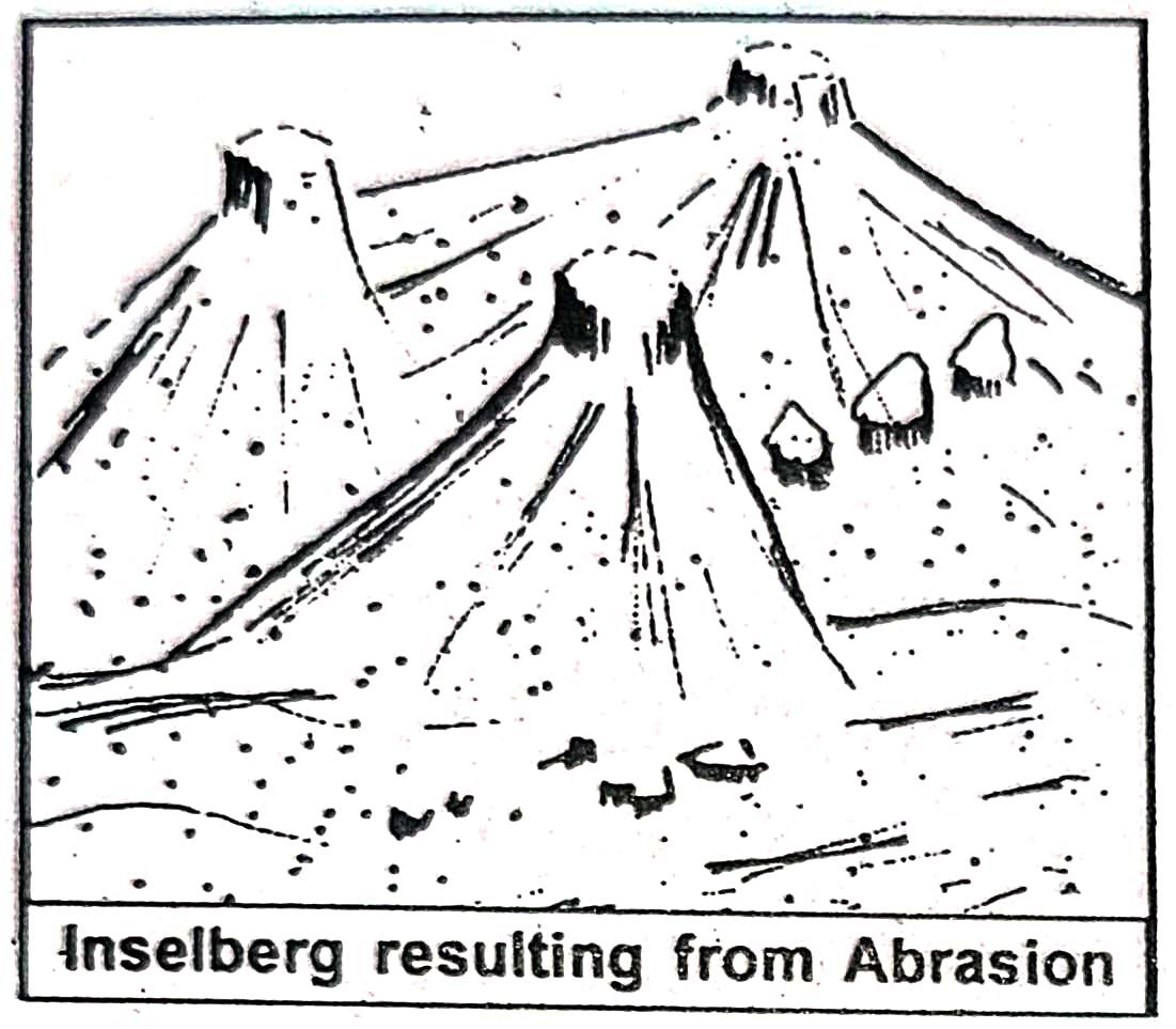
6. What is inselberg? Explain with diagram.
Answer: An inselberg is a noticeable steep-sided small hill or rocky mound that rises suddenly from a flat or gently sloping plain. It is mainly formed due to the abrasive action of strong wind erosion. Inselbergs usually have a dome-like top. The upper portion of an inselberg is steeper because the wind blows more forcefully there compared to the lower part. Such features are commonly found in deserts with strong, high-speed winds.
deserts noted for high velocity Inselberg resulting from Abrasion
7. What is oasis? What is its significance?
Answer: An oasis is a fertile spot found in desert regions, usually containing a small spring and some vegetation. Due to the removal of surface materials by wind, certain areas may sink close to the underground water level, forming depressions known as oases. These are green patches of water and plants in dry, sandy lands. Oases are important as they provide space for human settlement, opportunities for farming, and other economic activities. They also help travelers by offering water, shade, and rest in the harsh desert environment.
8.What are sand dunes? How are they formed?
The process begins when the wind picks up loose, dry sand and transports it through processes like saltation (hopping or bouncing of sand grains) and suspension (carrying fine particles in the air). When the wind meets an obstacle such as a rock, plant, or even a small uneven surface, it slows down, and the sand starts accumulating around that obstacle. Gradually, more and more sand gathers, forming a dune.
Sand dunes can take various shapes depending on the direction and strength of the wind, as well as the amount of sand available. Some common types include crescent-shaped barchans, long seif dunes, and star dunes. These formations are not permanent—they keep shifting their position and shape over time due to the constant movement of wind.
Thus, sand dunes act as significant features of deserts, indicating the active role of wind in shaping the landform of these arid regions.
9. What is abrasion? What are the features formed due to abrasion ?
Answer: Abrasion is a type of erosion caused by the rubbing, scraping, or wearing down of rock surfaces by particles carried by natural agents like wind, water, or ice. In deserts, strong winds carry sand and small rock fragments that hit against exposed rock surfaces, gradually eroding and polishing them. Similarly, in rivers, moving water with sediments grinds and smoothens the riverbed and banks. In glacial regions, ice loaded with rock debris scrapes the valley floor and sides.
The main features formed due to abrasion include:
Inselbergs: Isolated steep-sided hills rising abruptly from flat plains, mainly formed by wind abrasion in deserts.
Mushroom Rocks: Rocks shaped like a mushroom with a narrow base and wider top, created as wind erodes the lower portion more intensely.
Ventifacts: Stones that are polished, grooved, or shaped due to constant sand-blasting action of wind.
Yardangs: Long ridges of rock carved and streamlined by persistent wind abrasion.
Polished Surfaces in Glacial Valleys: Smooth and shiny rock surfaces formed by glacial abrasion.
Thus, abrasion plays a key role in shaping different landforms in deserts, river valleys, and glacial regions over long periods of time.
10. Define attritional
Answer: Attrition is a type of erosion in which rocks and sediments carried by natural agents like rivers, waves, or glaciers collide and rub against each other. Through this continuous collision, the particles break into smaller, smoother, and rounder pieces over time. This process reduces the size of the materials and makes them more polished.
11. What are glaciers? What is the reason for their slow movement?
Answer: Glaciers are massive bodies of ice that move slowly over the land surface, either as large sheets or as streams of ice flowing down mountain valleys under the influence of gravity. Generally, glaciers refer to huge accumulations of snow and ice on mountains that gradually descend along the valleys.
One of the main features of glaciers is their very slow movement, which is primarily due to their enormous size. The movement speed of glaciers is influenced by several factors, such as their thickness, the steepness and shape of the mountain slope, and the surrounding temperature. As a result, large ice masses move very slowly, whereas smaller blocks of ice can move relatively faster.
12. What are the different types of glaciers? Write briefly about each of them.
Answer: Glaciers are massive sheets of ice and snow that move slowly over land or slide down mountain slopes under the force of gravity. Based on their location and characteristics, glaciers are mainly divided into three types:
(i) Continental Glaciers: These are vast ice sheets that cover large parts of the polar regions. Their movement is extremely slow because of their massive size and the gentle slope of the polar surface. Examples include the ice sheets of Greenland, Antarctica, Northern Canada, and Scandinavia.
(ii) Mountain Glaciers: These glaciers form in high mountainous regions and are also known as Alpine or Valley glaciers. They flow down the valleys between mountains and move faster compared to continental glaciers. Such glaciers are found in the Himalayas (Asia), the Alps (Europe), and the Rockies (North America).
(iii) Piedmont Glaciers: These glaciers form when several mountain glaciers come together at the foothill areas of mountains. Since they originate in the piedmont zone, they are called piedmont glaciers. A common example of this type is found in Alaska, North America.
13. Draw a figure to show the shape of a glacier valley.
Answer:
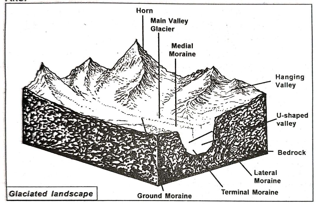
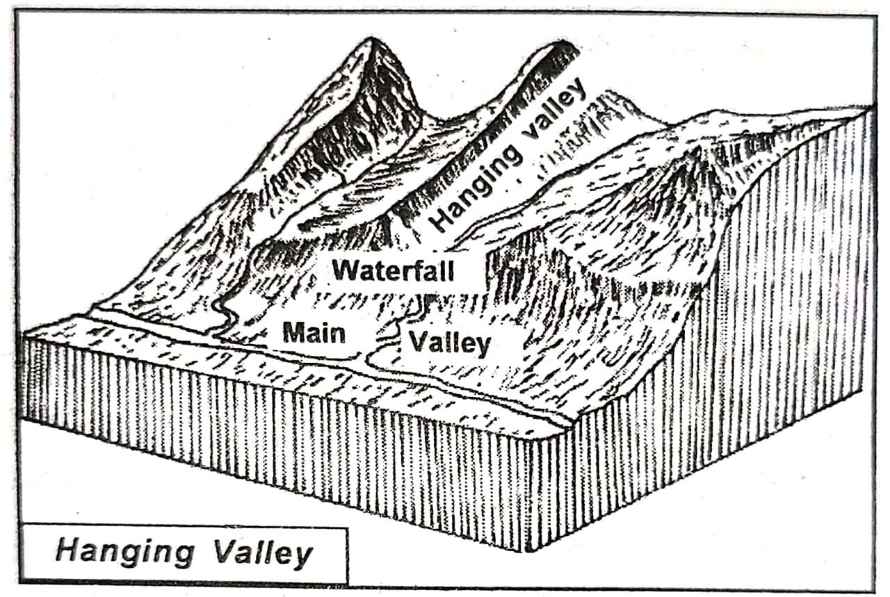
14. Write what is a hanging valley.
Answer: A hanging valley is an erosional landform created by glacial activity. When a large glacier moves through a mountainous region, it carves out a broad, deep valley. In the same region, smaller tributary glaciers also exist, which form narrower and shallower valleys. When these tributary glaciers join the main glacier, their valleys appear to be suspended above the main valley, giving the impression that they are “hanging.” Such valleys are known as hanging valleys. Often, when water flows from these hanging valleys into the main valley, it forms waterfalls.
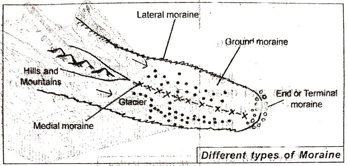
Answer: Moraines are long ridges or accumulations of glacial debris such as rocks, clay, sand, and boulders, transported and deposited by a moving glacier. These are depositional features of glaciers that significantly alter the landscape by leaving behind large amounts of sediment.
Moraines are mainly classified into four types:
(i) Lateral Moraine: These are ridges of glacial debris deposited along the sides of a glacier valley. They form between the ice mass and the steep walls of the valley, running parallel to the glacier’s flow.
(ii) Ground Moraine: Found at the base of the glacier, ground moraines are formed when sediments are deposited unevenly as the glacier moves. These deposits leave behind irregular sheets or tills covering the valley floor.
(iii) Medial Moraine: When two glaciers merge, their lateral moraines also come together and move down the center of the glacier valley. These moraines, running along the middle course of a glacier, are called medial moraines.
(iv) Terminal Moraine: Also known as end moraine, it marks the furthest point reached by a glacier. It forms at the glacier’s snout where the ice melts and deposits its sediment load. These moraines often contain large, angular rocks and boulders.
16. Based on your general knowledge, state how global warming may have its various effects on glaciers.
Answer: Global warming refers to the gradual rise in the Earth’s average atmospheric and oceanic temperatures caused by the excessive emission of greenhouse gases such as carbon dioxide, methane, nitrous oxide, chlorofluorocarbons (CFCs), and water vapor. This warming is primarily driven by the greenhouse effect, which traps heat in the atmosphere.
One of the major negative impacts of global warming is its effect on glaciers in polar regions as well as in high mountain ranges across the world. Rising global temperatures lead to abnormal and accelerated melting of glaciers, which in turn alters the landforms in these regions. Studies have already shown that polar ice is melting rapidly, contributing to the rise in sea levels. This can result in flooding, loss of marine habitats, and serious ecological imbalance.
Similarly, scientists have warned that the Himalayan glaciers may melt faster than anticipated. This would severely impact the Indian subcontinent by reducing the flow of perennial rivers that sustain the northern and north-eastern plains. Such a situation would cause a decline in freshwater availability, affecting agriculture, drinking water supply, and overall human survival. Since glaciers are among the best sources of freshwater, their depletion could significantly threaten life on Earth in the coming decades.
Class 10 Geography Chapter 1 – Physical Geography FAQs
Get Free NCERT PDFs
If you want to download free PDFs of any chapter, click the link below and join our WhatsApp group: