Class 10 Geography Chapter 3 – Concept of Region and Regional Geography of the World All Exercise Solutions | SEBA Assam (English Medium)
Class 10 Geography Chapter 3 – Concept of Region and Regional Geography of the World (SEBA Assam – English Medium)
The third chapter of SEBA Class 10 Geography, Concept of Region and Regional Geography of the World, focuses on the meaning, significance, and classification of regions. It guides students to understand how geographers divide the world into distinct regions based on physical, cultural, political, and economic criteria. It also explains the importance of regional geography in analyzing different parts of the world systematically. This chapter has high value for HSLC exam preparation as it includes theoretical definitions, classification tables, case studies, and map exercises.
✅ What You Will Learn in Chapter 3:
- Definition and concept of region in Geography
- Types of regions – physical, cultural, political, and economic
- The role of regional geography in studying the world
- World regions and their key characteristics
- Importance of studying regions for understanding development and interactions
🎯 Why Choose Ospin Academy Solutions:
- Complete SEBA Assam Class 10 Geography Chapter 3 solutions
- All textual exercises and important HSLC-focused notes solved
- Answers provided in simple and clear English
- Includes MCQs, long-answer questions, and map-based solutions
- Best for quick revision and board exam practice

Class 10 Geography (English Medium) HSLC 2026 Textual Solutions PDF | SEBA Assam Syllabus
Limited Time Offer!
(For HSLC Exam 2026)
Get complete preparation for Class 10 Geography (English Medium) with this all-in-one SEBA textual solution PDF.
Covers chapter-wise solutions, definitions, map work, diagrams and practical geography – fully updated for HSLC 2026 syllabus.
Perfectly designed for revision, practice and boosting exam scores!
Class 10th Geography(E)
Concept of Region and Regional Geography of The World
TEXTUAL QUESTIONS AND ANSWERS
1. What do you mean by a region? Explain the importance of region in geographical study. Answer: Any part of the earth’s surface which is unique and distinct from the surrounding areas is called a region in geography. In other words, a region refers to an area of the earth’s surface characterised by certain noticeable natural or man-made features that make it different from its neighbouring areas.
For example, places that receive high rainfall due to monsoon winds in summer are grouped together as a monsoon region.
Regions can be identified based on:
- Natural characteristics – rainfall, temperature, soil type, natural vegetation, topography, etc.
- Man-made characteristics – population density, economic activities, industrial development, etc.
One major aim of geography is to study the earth’s surface, but as it is vast and diverse, this becomes easier when the earth is divided into regions and studied individually.
Importance of regions in geographical study:
- Makes the study of geography simpler, clearer, and more systematic.
- Helps governments and agencies plan regional development and maintain balanced growth.
- Experiences from one region can guide development in other regions with similar features.
- Enables comparative study between different areas.
- Forms the basis of the regional approach, which is one of the most accepted methods in geography.
Thus, demarcating and studying regions is a key aspect of regional geography.
2. Explain how a region can be identified on the earth’s surface.
Answer: A region in geography refers to a part of the earth’s surface that possesses distinct and recognisable natural or human-made characteristics, making it different from the surrounding areas. In other words, it is any section of the earth that stands out due to its unique features. A region can be classified or identified mainly in two ways:
- Based on Homogeneity
- Based on Functional Interrelationship
1. Based on Homogeneity One of the notable aspects of the earth’s surface is its great diversity. This diversity arises due to several factors such as the earth’s location in the solar system, its shape, internal structure, rotation, revolution, and more. These factors cause variations in climate, rainfall, temperature, soil, and other physical conditions across different places.
Areas that share similar climate, rainfall, temperature, soil conditions, or economic activities are grouped together to form a homogeneous region. For example, the entire Brahmaputra valley in Assam can be treated as one region because it exhibits uniform conditions in terms of climate, rainfall, temperature, and soil. Thus, regions identified on this basis reflect uniformity in physical or human characteristics like soil, vegetation, or occupations.
2. Based on Functional Interrelationship A region can also be identified through the functional connections between its different parts. This type of region is generally centred on a town, city, market, or industrial hub where various activities are interdependent.
For example, the area surrounding Kolkata functions as a region because it supplies essential goods, services, and manpower to the city, while the city, in turn, supports the livelihoods and economic needs of the surrounding population. The elements within such a region may not be physically similar, but they remain closely linked through mutual dependency. Similar examples are found around major industrial centres, tourist destinations, and educational hubs.
3. Bring out the differences between the homogeneous region and the functional region.
Answer: The differences between the homogeneous region and the functional region are:
|
SI No |
Basis of distinction |
Homogeneous Region |
Functional Region |
|
(i) |
Meaning |
A region where selected elements show uniformity. |
A region where socio-economic activities are connected to a central place like a town or market. |
|
(ii) |
Basis |
Identified based on uniformity or similarity of elements. |
Identified based on the functional connections among elements. |
|
(iii) |
Elements |
The selected elements remain similar throughout the region. |
The internal elements of the region are not similar. |
|
(iv) |
Dependency |
Different parts of the region are not mutually dependent. |
The internal elements are not necessarily similar. |
|
(v) |
Examples |
The Brahmaputra Valley, Amazon Basin, Equatorial Region, etc. |
Regions around cities like Guwahati, Kolkata, Delhi, etc. |
4. What do you mean by regional geography of the world? What is the importance of this study?
Answer: The branch of geography that focuses on studying the natural as well as human-made characteristics of a specific area is known as regional geography. In simple terms, it refers to the study aimed at understanding the distinct features of a region to gain a clearer understanding of the geographical diversity of the earth. Regional geography presents a detailed geographical description of any region, country, or even a continent.
The earth, being a massive planet with a total surface area of about 510 million sq. km (149 million sq. km of land and 361 million sq. km of water), cannot be effectively studied as a single unit. Additionally, the planet exhibits wide-ranging variations in its natural and human features. Therefore, based on either the similarities of certain factors or the functional interconnections among them, the earth is divided into separate regions. These regions are then studied individually, making the study of the planet more systematic and easier to comprehend. The process of studying such divisions is termed regional geography.
Some of the key reasons that highlight the importance of regional geography are as follows:
(i) It helps us understand the factors responsible for the underdevelopment of certain regions.
(ii) It assists in planning and implementing proper developmental programmes for different regions of a country.
(iii) Geography becomes easier to interpret when studied from a regional perspective.
(iv) It provides a comprehensive picture of an entire region.
(v) Through this study, detailed information about physical environment, economic activities, settlement patterns, transport, and communication systems of a place can be obtained.
(vi) Regional geography helps to identify the spatial differences within a region.
(vii) It provides insight into the geographical relationships between a particular region and its surrounding areas.
(viii) By analysing regions, one can assess the socio-economic growth and the challenges faced by a country or area.
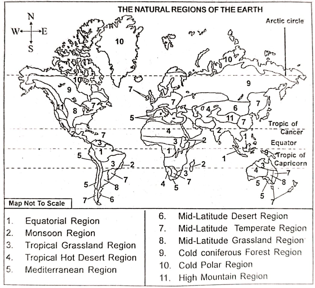
5. What do you mean by ‘natural region’? Into how many natural regions, the whole earth can be divided? Write their names and show in the map.
Answer: A natural region refers to a part of the Earth divided into specific geographical units that share similar natural characteristics such as relief, climate, rainfall, temperature, soil, and natural vegetation. In other words, it is an area where these physical and geographical features show a certain level of uniformity.
The Earth can broadly be classified into the following eleven natural regions:
- Equatorial Region
- Monsoon Region
- Tropical Grassland Region
- Tropical Hot Desert Region
- Mediterranean Region
- Mid-latitude Desert Region
- Mid-latitude Temperate Region
- Mid-latitude Grassland Region
- Cold Coniferous Forest Region
- Cold Polar Region
- High Mountainous Region
6. How can the regional geography of the world be understood through the study of natural regions? Write in brief.
Answer: A natural region is a division of the Earth based on similarities in geographical characteristics like relief, climate, rainfall, temperature, soil, and natural vegetation. The primary basis for dividing the Earth into natural regions is geographical uniformity. Due to these similarities, various places around the world can be grouped under common divisions.
One major advantage of studying natural regions is that it makes understanding regional geography easier and clearer. For example, the Coastal Californian region has a Mediterranean climate, similar to that found around the Mediterranean Sea. Hence, the climate, vegetation, and economic activities of California can be better understood by studying it as part of the Mediterranean natural region.
This approach helps reveal the interrelationship between different regions of the world and simplifies the study of regional geography. Moreover, it is useful in planning developmental projects. Agencies working in a specific region can apply knowledge gained from similar natural regions to make informed decisions, avoid expensive errors, and implement better development strategies.
7. Write about the physical environment of each of the natural regions of the world.
Answer: The physical environment of each of the eleven natural regions of the world is discussed below:
(i) Equatorial region: This region is characterised by a hot and wet climate with heavy rainfall. The region is almost entirely covered by dense evergreen forests. As this region experiences vertical sunrays, the temperature difference between day and night and summer and winter is very low here.
(ii) Monsoon region: This region has warm and wet summers and cold and dry winters. The average annual rainfall is 200 cm and deciduous vegetation is prevalent. The highlands have laterite soil while the low-lying areas and river valleys have fertile alluvial soil.
(iii) Tropical grassland region: This region experiences a short and warm summer season and a long and dry winter season, with high diurnal and seasonal range of temperature. The amount of rainfall is moderate i.e. about 25-100 cm and tropical grasslands are seen in this region.
(iv) Tropical hot desert region: This region has a hot and dry climate throughout the year, with high diurnal range of temperature. Rainfall is almost negligible (20-25 cm annually). Unlike other regions, most part of this region remains covered with sand. Only short grass and thorny shrubs are found over the vast sandy areas.
(v) Mediterranean region: The climate here is a hot and dry summer and cold and wet winter. The average annual temperature is 8°-25°C and annual rainfall is 25-75 cm. The vegetation consists of evergreen short trees and shrubs.
(vi) Mid-latitude desert region: This region is surrounded by high mountains on almost all sides. The rainfall is very low and the seasonal and diurnal range of temperature is very high. A little amount of snowfall also occurs in the winter season.
(vii) Mid-latitude temperate region: The coastal areas of this region have an equitable climate with average summer temperature of 15°C and average winter temperature 5°-10°C. In the mid-latitude temperate region, the intensity of summer and winter is less. The rainfall too is between 75-150 cm annually but decreases with increase in distance from the sea. Winters are dry. Though deciduous vegetation is common, evergreen trees are found in areas of higher rainfall and coniferous trees are found on hill slopes.
(viii) Mid-latitude grassland region: This region receives very low rainfall, only 15-50 cm annually. The seasonal range of temperature is high and winters are severe. Though vegetation is almost absent, grasslands are common. The soil is rich in organic matter and thus fertile.
(ix) Cold-coniferous forest region: The climate here is dry and cold. Summer temperatures reach 15°C and snowfall occurs in winter. The little rainfall is received in summer. Softwood evergreen forests called Taiga, cover the region.
(x) Cold polar region: This region is covered with snow almost throughout the year. The short summers have temperatures from 0°-10°C, while during the long winters temperatures fall to -18°C with heavy snowfall. Almost no vegetation except for some grass, moss, fern, etc. is found here. Rainfall is almost nil in this region..
(xi) High mountainous region: In these high peak areas, temperatures decrease with altitude. While windward sides receive rainfall and have forest growth, the leeward sides are dry and devoid of vegetation. High peaks are always covered with snow.
8. Discuss about the climate and vegetation as found in different natural regions of the world.
Answer: Natural regions are areas with similar climate, rainfall, soil, and vegetation. Each region has its own climatic characteristics and distinct vegetation types.
(i) Equatorial Region
Climate:
- Hot and wet throughout the year.
- Very low temperature variation (avg. 27°C).
- Heavy annual rainfall (~200 cm).
Vegetation:
- Dense evergreen forests with climbers and shrubs.
- Selvas (dense forests) in the Amazon basin.
- Crops: rice, rubber, tea, coffee.
(ii) Monsoon Region
Climate:
- Rainfall mainly in summer (~200 cm annually).
- Warm, wet summers; cold, dry winters.
- Temperature difference: ~15°C.
Vegetation:
- Deciduous forests that shed leaves in dry season.
- Crops: rice, sugarcane, wheat, cotton, jute, oilseeds, tea.
(iii) Tropical Grassland Region
Climate:
- Short warm summers, long dry winters.
- High diurnal and seasonal temperature range.
- Moderate rainfall (25–100 cm).
Vegetation:
- Tall grasses (up to 3 m) called Savannah (Llanos in Venezuela, Campos in Brazil).
- Crops: jowar, cotton, groundnut.
(iv) Tropical Hot Desert Region
Climate:
- Very hot and dry with extreme day–night temperature variation.
- Summer temperature: up to 45°C.
- Very low rainfall (20–25 cm).
Vegetation:
- Sparse thorny bushes and short grass.
- Oasis cultivation: date palm.
(v) Mediterranean Region
Climate:
- Hot, dry summers and cold, wet winters.
- Average temperature: 8°–25°C.
- Rainfall: 25–75 cm, mostly in winter.
Vegetation:
- Evergreen shrubs and short trees.
- Crops: wheat, barley, maize, cotton, tobacco, grapes, apples.
(vi) Mid-Latitude Desert Region
Climate:
- Extreme summer–winter temperature difference.
- Very low rainfall.
- Some snowfall in winter.
Vegetation:
- Sparse shrubs and thorny bushes.
(vii) Mid-Latitude Temperate Region
Climate:
- Mild summers (15°C) and cold winters (5°–10°C).
- Rainfall: 75–150 cm, decreases inland.
- Winters are relatively dry.
Vegetation:
- Mixed: deciduous, evergreen, and coniferous.
- Crops: cotton, barley, tobacco, potato.
(viii) Mid-Latitude Grassland Region
Climate:
- Severely cold with high temperature variation.
- Low annual rainfall (15–50 cm).
Vegetation:
- Sparse; mainly grasslands (Steppes in Asia/Europe, Prairies in North America, Pampas in Argentina, Veld in South Africa, Downs in Australia).
- Dense forests on windward slopes, leeward slopes are dry.
9. Give a description of the lifestyle of the people living in different natural regions of the world.
Ans The economic occupation and the lifestyle of the people living in different natural regions are not same due to variations in climate, soil, topography, location, distance from the sea, altitude, etc. The main economic activities found in different natural regions of the world are:
(i) Equatorial region: The main areas that fall under the equatorial region are the Amazon river basin of South America, Congo basin (now called Zaire basin of Africa). Guinea coast of west Africa, Malaysian peninsula, Indonesian and Philippines islands of south-east Asia. The people of both Amazon and Congo basin make their living through hunting, fishing and gathering food from the forest. Due to dense forest and lack of transport and communication, agriculture and human settlement have not developed greatly. Although, Malaysia and Indonesia also belong to this natural region, yet these regions, have made a lot of progress in agriculture, particularly in plantation agriculture such as coffee, tea and rubber.
(ii) Monsoon region: The areas included under monsoon region are South Asia including India, south-east Asia, north-eastern part of Australia, eastern part of Africa, eastern part of Brazil, Central America, etc. It is one of the most thickly populated regions of the world. Agriculture is the main occupation of the people of the monsoon region. Crops such as rice, jute, tea, oilseeds, cotton, sugar cane, wheat, etc. are extensively cultivated. Many of the countries of this group are rich in natural resources and so a good number of people are also engaged in the extraction, purification and development of the resources leading to economic advancement of this region.
(iii) Tropical grassland region: This area which includes the regions of South America, Africa and Africa that lie between 10°-25° latitudes, mostly consists of grasslands which are generally called Savannah. They are also known by different names in different countries. For example, in Venezuela and Brazil they are called Llanos and Campos respectively. Primitive groups of people live in this region. They are mostly engaged in animal rearing and hunting. Cultivation of crops such as jowar, cotton, groundnut, etc. is done on a small-scale in some parts. The human habitation is quite thin in this region. Due to lack of sufficient transport and communication facilities, this region lags behind in economic and social development.
iv) Tropical hot desert region: The deserts of Arabia, Iran, (Afghanistan, Indian Thar desert of Asia, Sahara and Kalahari deserts of Africa, Atacama desert of South America, Great desert of Australia, etc. fall under tropical hot desert region. Most areas of these desert regions are uninhabited. Some areas are inhabited by pastoral nomads. The Bushmen of Kalahari desert, the aborigines of Great desert of Australia, Bedouins of Sahara and Arabia are the main groups of people who live in this region. Most people of this region earn their livelihood by rearing camel, horse, sheep, goat, etc. The Nile valley region has made some progress in agriculture while the Arabian countries Kuwait, Saudi Arabia, Iran, Iraq, etc. have made economic progress due to the discovery of oil.
(v) Mediterranean region: The Mediterranean region is largely found in the neighbouring areas of the Mediterranean Sea including southern Europe, south-western Asia, northern Africa, coastal California of North America, central Chile of South America, Cape coast of South Africa, south-west coast of Australia, etc. The main occupation of the people of the Mediterranean region is agriculture. The crops cultivated in the region include wheat, barley, maize, cotton, tobacco, etc. These crops are cultivated depending on winter rainfall and irrigation facility. This area is famous for the cultivation of several fruit trees such as grapes, apples, etc. This has helped the development of fruit-based industries on a large-scale, which includes the world famous wine production.
(vi) Mid-latitude desert region: The Tibetan plateau, Gobi desert, basins surrounded by the Rocky mountains of North America, Patagonia plateau of South America, etc. belong to this natural region. Some pastoral nomadic groups of people inhabit the Tibetan and Patagonia plateaus and parts of Gobi desert. They move around in search of food for animals and have no permanent settlements. Agriculture is practised in irrigated areas and exploitation of minerals has led to some industrialisation and resultant economic progress.
(vii) Mid-latitude temperate region: This region includes northern and eastern China, some parts of southern Canada, England, north-western Europe, south-eastern Brazil, Uruguay, southern Chile and eastern coasts of South Africa, Australia and New Zealand. The main occupation of the people of this region is agriculture. Highly developed form of agriculture is practiced here. Crops like cotton, tobacco, barley, potato, wheat, rice and sugar cane are grown extensively. Animal rearing is also practised commercially in many parts of this region. Industrial activities have also developed due to the availability of mineral resources. The whole region is industrially advanced.
(viii) Mid-latitude grassland region: The mid-latitude grasslands are situated in almost all continents. These grasslands are known by different names in these continents. They are known as Steppes in Asia and Europe, Prairies in North America, Pampas in Argentina of South America, Veld in South Africa and Downs in Australia. Most of the people living in these grassland regions are aborigines. Livestock rearing is the main economic activity over here. Nevertheless, large-scale agricultural production is done in the grasslands of the United States, Canada, Argentina, Australia and Russia. Wheat is cultivated in many parts of this region. Animal rearing has also reached high development and so dairy milk industries have come up as a result of the application of modern scientific methods of rearing of cattle, buffalo, cows and sheep. Wool is also exported from these countries.
(ix) Cold coniferous forest region: This region is spread from Scandinavia of Europe to the Pacific coast in the east and from Alaska of north America to the Atlantic coast in the east. This region is not suitable for agriculture and livestock rearing. Most of the people of this region eam their livelihood by animal hunting and wood collection.
The European countries such as Norway, Finland, Sweden, etc. have developed paper industries and wood-based industries. The discovery of several minerals in Canada, Alaska and Siberia has quickened the economic development of this region. A little agriculture and sheep rearing is now practised in the southern part of the Taiga region.
(x) Cold polar region: The areas around the poles including parts of Asia, Europe, North America, Greenland, Siberia and Antarctica fall under the cold polar region. This region is mostly inhabited by aborigines called Eskimos and Lapps. They live in Igloos in winter and in tent houses called Tupik in summer. They live by fishing and hunting. The sledge vehicle pulled by reindeer is the most important means of transport among these people. With the gradual expansion of communication, many people of this region have stared living in permanent homes. Fishing and animal hunting have become more modern. In Siberia, reindeer is reared scientifically on commercial basis. The discovery of petroleum and gold in Alaska, iron in Labrador and nickel in Siberia has brought in a lot of economic progress in the region.
(xi) High mountainous region: This region includes the mountain ranges of the Himalayas, the Alps, the Rockies and the Andes. This region is thinly populated. Livestock rearing and lumbering are the main occupations of the people. Cultivation is done only in the river valleys. The tribal people living in these hilly regions practise shifting cultivation or jhum cultivation. Exploration of minerals is also done where available. Many places of mountainous region have become tourist and health resort centres. This has led to the fast development of the region.
10. How many and what are the continents in the world? Give a brief geographical introduction of each of the continents.
Answer: There are seven continents in the world. Among these seven, the snow-covered continent of Antarctica does not have any permanent human settlement and so this continent remains a continent only in name. The other six continents are Asia, Africa, Europe, North America, South America and Oceania.
(i) Asia: Asia is the largest continent in the world. It has a geographical area of 44.4 million sq. km which constitutes about 30% of the earth’s land surface area. It lies mostly in the northern hemisphere. The continent spreads from 1°N latitude in the south to 78°N latitude in the north and 25°E longitude in the west to 170°W longitude in the east. The continent of Asia is surrounded by the Northern Ocean in the north; the Bering Strait and the Pacific Ocean in the east; Indian Ocean in the south and the Red Sea, the Suez Canal, the Mediterranean Sea, the Caucasus mountains, the Caspian Sea, the Ural river and the Ural mountains in the west. Its length from north to, south is 8,400 km while its width from east to west is 9,600 km. It has a coastline of 58,000 km.
(ii) Africa: Africa is the second largest continent in the world. Its total geographical area is 30 million sq. km. It has 20% of the world’s total land area. The equator passes through the middle of the continent and divides it into two parts. It lies between 37°N latitude in the north to 34°S latitude in the south and 51°E longitude in the east to 17° W longitude in the west. Africa is surrounded by the, Mediterranean Sea in the north; the Southern Ocean in the south; the Indian Ocean in the east and the Atlantic Ocean in the west. It has a coastline of 30,000 km.
(iii) Europe: The continent of Europe is situated completely in the northern hemisphere. It has a geographical area of 10.9 million sq. km which constitutes about 7.3% of the world’s land area. It lies between 36° N latitude in the South to 71°N latitude in the north and 10° W longitude in the west to 65° E longitude in the east. The northern boundary of Europe is the Northern Ocean while the Mediterranean Sea, the Caspian Sea and the Black Sea constitute the southern boundary. The continent of Asia lies in the east and the Atlantic Ocean on the west. The Ural mountain ranges and the Ural river separate the continent of Europe from Asia. Europe has a coastline of 38,000 km.
(iv) North America: North America is the third largest continent in the world. Its total geographical area is 24.3 million sq. km. North America has 16.3% of the world’s total land area. It lies from 7°N latitude in the south to 83°N latitude in the north and 50°W longitude. The north to south distance is 9,600 km while the east to west distance is 4,960 km. This continent is bounded by the Northern Ocean in the north; South America, the Gulf of Mexico and the Pacific Ocean in the south; the Atlantic Ocean in the east and the Bering Sea, the Bering Strait and the Pacific Ocean in the west.
(v) South America: The continent of South America extends from 12°N latitude in the north to 55°S latitude in the south and 35°W longitude in the east to 81°W longitude in the west. It has a reversed triangle shape. In other words, its northern part is very wide and southern part is quite narrow. The total geographical area of South America is 18 million sq. km. which constitutes about 12.2% of the world’s total land area. Its length from north to south is 7,500 km and 5,100 km, from east to west. The continent of South America is bounded by North America, the Caribbean Sea and the Atlantic Ocean in the north; the Southern Ocean on the south; the Pacific Ocean on the west and the Atlantic Ocean in the east.
(vi) Oceania: The continent of Oceania consists of the great island of Australia and other islands such as New Zealand, Tasmania, New Guinea, etc. It lies completely in the southern hemisphere. It spreads from 0º equator in the north to 48°S latitude in the south, and 113°E longitude in the west to 180° longitude in the east. Total land area of Oceania is 9 million sq. km. It is the world’s smallest continent. It is surrounded by the Java-Sumatra-Celebes islands of the South-East Asia and the Pacific Ocean in the north; the Southern Ocean and Antarctica on the South; the Pacific Ocean on the east and the Indian Ocean on the west.
11. Which is the largest continent in the world? Write briefly about the physiographic character of the continent.
Answer: Asia is the largest continent in the world, covering about 44.4 million sq. km, which is nearly 30% of the total land area of the Earth. Most of this continent lies in the northern hemisphere. The main physiographic features of Asia are:
(i) Mountain ranges: The central region of Asia consists of a series of young fold mountains stretching from west to east. These ranges arise mainly from two significant knots – the Pamir Knot and the Armenian Knot. Major mountain systems include the Ural Mountains, Himalayas, Karakoram, Hindu Kush, and the Aravallis. The world’s highest peak, Mt. Everest, is located in the Himalayas, while the second-highest peak, Godwin Austin (K2), lies in the Karakoram range.
(ii) Plateaus: Asia contains many plateaus. The Pamir Plateau, the highest in the world, is located here. Other important plateaus include the Tibetan, Siberian, Mongolian, Deccan, and Iranian plateaus.
(iii) Rivers: Asia is rich in rivers, many of which rise from the central mountains and flow north, south, and east into various seas and oceAnswer: Major rivers include the Indus, Ganga, and Brahmaputra in south-central Asia; Ob, Yenisei, and Lena in northern Asia; Amur, Hwang-ho, Yangtze, Si-Kiang, and Mekong in the east; and Mahanadi, Krishna, Kaveri, Menam, Irrawaddy, and Mekong in the south and southeast.
(iv) Fertile plains and deltas: Numerous fertile plains and deltas have been formed by Asian rivers. Coastal plains are also found along the north-eastern and southern coasts of the continent.
(v) Islands: Asia includes many significant islands such as Japan, Taiwan, Philippines, Java, Sumatra, Borneo, Celebes, Andaman and Nicobar Islands, Sri Lanka, Lakshadweep, Maldives, and Bahrain. The level of development of these islands depends on their topography, climate, and location.
(vi) Deserts: There are three major deserts in Asia – the Gobi, the Thar, and the Arabian deserts. The Thar in India and the Arabian Desert fall in the tropical hot desert zone, while the Gobi Desert is part of the mid-latitude desert zone.
12. Which is the most populous continent in the world? Write in brief about the population and economic characteristic of that continent.
Answer: Asia is the most populous continent in the world. As per the 2007 estimate, its population stands at around 401 crores, which accounts for nearly three-fifths of the global population. The population distribution is highly uneven because of differences in climate, altitude, soil, and distance from the sea. Nearly three-fourths of the population lives in the southern, south-eastern, and eastern parts of Asia. Around 61% of Asia’s total population resides in India and China. China is the most populated country, followed by India. Tokyo, with a population of about 34 million, is the largest city in the world. Other densely populated cities include Beijing, Mumbai, Delhi, Kolkata, Singapore, Seoul, Shanghai, Hong Kong, Bangkok, Kuala Lumpur, and Taipei. Nearly 41% of Asia’s population lives in urban areas.
Asia is abundant in natural resources, which form the basis of its economic activities. Agriculture remains the primary source of livelihood. Major crops include rice, wheat, sugarcane, tobacco, cotton, tea, rubber, and coffee. The continent is also rich in mineral resources: petroleum is found in Saudi Arabia and other parts of southwest Asia, India, Myanmar, Indonesia, China, and Siberia; coal and natural gas occur in India, Myanmar, China, and Siberia; iron ore is found in India, China, Siberia, Indonesia, and the Philippines; and manganese is available in India and Siberia.
13. Mention the geographical characteristics of the continent of Europe.
Answer: The total geographical area of Europe is 10.9 million sq. km which is 7.3% of the world’s total land area. The continent of Europe is located completely in the northern hemisphere. Following are the chief geographical characteristics of Europe:
(i) Physiographic divisions: Geographically, Europe can be divided into two parts:
(a) The northern part and
(b) The southern part.
The northern part extends from coastal France on the west to the Ural mountain ranges in the east. This area is a plain. The southern part extends from Spain to the Black Sea. This area is covered with hills, mountains and plateaus. The northern frontier region and the southern highland region of North America are quite under the influence of glaciers.
(ii) Mountain ranges: Europe has a series of mountain ranges such as the Alps, the Pyrenees, the Carpathian and the Caucasus mountain ranges. Albrus peak (5,633 m) situated in the Caucasus mountain range is the highest peak of Europe while Mount Blanc (4,807 m) is the highest peak of the Alps.
(iii) Rivers and lakes: Europe is blessed with several rivers. The important rivers of this continent are the Elbro of Spain; the Rhone and the Seine of France; the Rhine and the Elbe ‘of Germany; the Oder and the Vistula of Poland; the Danube of Austria, Hungary and Romania; the Dnieper of Balarus and Ukraine; the Po of Italy; the Thames of Great Britain; the Don, the Volga and the Ural of Russia, etc. The Onega, the Ladoga, the Chudskoye, the Vanem, etc. are the important lakes of Europe.
(iv) Islands: Europe has several islands. These include the British Isles, Ireland, Iceland and Shetland of the Atlantic Ocean; Crete, Sicily, Malta, Sardinia, Corsica and Belcaric islands of the Mediterranean Sea and Gotland, Aland, Novaya, Jemlya, Svalbard and Greenland of the Northern Ocean.
14. Write briefly about the topography and mineral resources of the continent of North America.
Answer: North America is the third-largest continent in the world, covering about 24.3 million sq. km, which makes up nearly 16.3% of the Earth’s total land area.
Its major topographical and mineral characteristics are as follows:
[I] Physiographic divisions: North America can be divided into four major regions:
(i) The Rocky Mountainous Region: Found in the western part, this region consists of a chain of high fold mountains stretching from Alaska in the north to Mexico in the south. Key mountain ranges include the Brooks Range, Alaska Range, Mackenzie Range, Coast Range, Cascade, Sierra Nevada, and Sierra Madre. Two main north-south parallel mountain systems dominate here: the Rocky Mountains in the east and the Coastal Mountain ranges in the west.
(ii) The Great Upland Plain Region: Located between the Rocky Mountains and the Appalachian Highlands, this extensive area runs from northern Canada to the Gulf of Mexico. It comprises erosional plateaus and fertile plains, especially in the south, where rivers like the Mississippi, Missouri, and Ohio have created fertile lands.
(iii) The Appalachian Highland Region: Situated in the eastern part of the continent, it extends from Newfoundland in the north to Florida in the south. This area has rugged hills, mountains, fragmented plateaus, and narrow river valleys. The Allegheny and Blue Ridge mountains lie in its southern part. This region is rich in minerals and is highly developed economically.
(iv) The Coastal Plain Region: A narrow strip of plain lies along the Atlantic coast, from Nova Scotia to Panama, rich in resources such as petroleum, natural gas, and salt. On the western coast, only a narrow plain exists in California, while the northern coastal belt from Alaska to Newfoundland is highly irregular.
[II] Rivers: Major rivers include the Missouri, Mississippi, Yukon, Mackenzie, Rio Grande, Red, Colorado, Columbia, Snake, Ohio, Tennessee, Hudson, and St. Lawrence. Major lakes are Superior, Huron, Michigan, Erie, Ontario, Great Bear, Great Slave, Winnipeg, and Great Salt Lake.
[III] Islands: Numerous islands are located in the northern and southeastern parts of the continent.
Mineral resources: North America is rich in minerals, which have contributed to its fast economic development. It has abundant deposits of iron, nickel, cobalt, and mica. Fossil fuels like coal, petroleum, and natural gas are produced in large amounts in Canada, the USA, and Mexico. Canada is also a leading producer of hydroelectric power.
15. Write in brief about the drainage and vegetation of the continent of South America.
Answer: South America is the fourth-largest continent in the world, covering about 18 million sq. km. Its major rivers include the Amazon, Orinoco, Paraná, Uruguay, and Paraguay. The Amazon originates in the Andes Mountains, flows through the equatorial forests of Brazil, and drains into the Atlantic Ocean, with numerous tributaries feeding it. The Paraná and Paraguay rivers start in the Brazilian plateau, flow separately for a distance, and then merge under the name Paraná. Further south, the Uruguay River joins the Paraná, and the combined flow enters the Atlantic Ocean as the Rio de la Plata. These river systems are significant for agriculture and trade, particularly in Uruguay, Paraguay, and Argentina. They have also formed extensive fertile plains that cover much of the continent.
The natural vegetation of South America changes with climate and landform. The Amazon basin, located in the equatorial zone, experiences high temperatures and heavy rainfall, supporting dense evergreen forests known as the Selvas. Moving north and south of the equator, rainfall decreases, leading to the development of vast grasslands. The grasslands of the Orinoco basin are called Llanos, while those in the Paraguay-Paraná-Uruguay basin are known as Campos, Gran Chaco, and Pampas.
16. Mention the major mountain systems and rivers of the world and show them in the map.
Answer: The major mountain systems of the world are:
(i) The Central mountain ranges of Asia.
(ii) The Alps mountain system of Europe.
(iii) The Rocky mountain system of North America.
(iv) The Andes mountain system of South America.
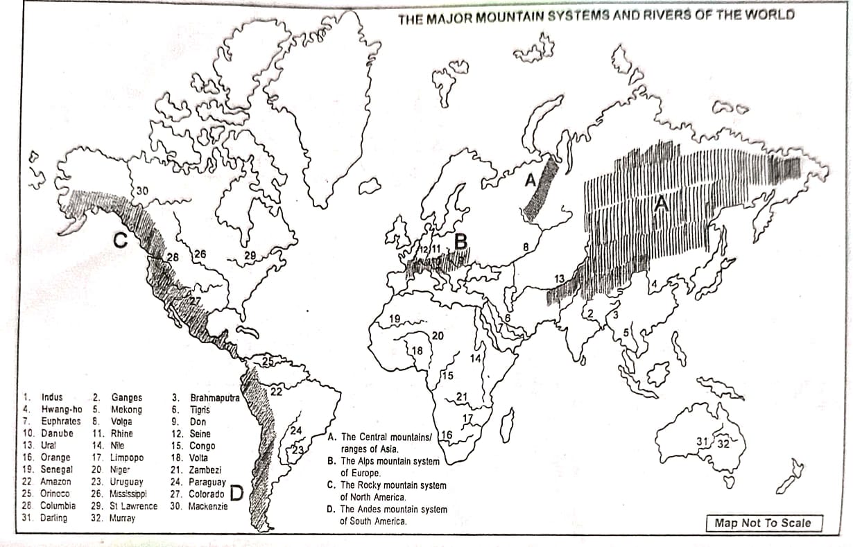
The major rivers of the world are:
(i) Asia: Indus, Ganges, Brahmaputra, Mekong, Hwang-ho, Tigris, Euphrates, etc.
(ii) Europe: Volga, Don, Danube, Rhine, Seine, Ural, etc.
(iii) Africa: Nile, Congo, Orange, Limpopo, Volta, Senegal, Niger, Zambezi, etc.
(iv) South America: Amazon, Orinoco, Uruguay, Paraguay,etc.
(v) North America: Columbia, Colorado, St Lawrence, Mississippi, Mackenzie, etc.
(vi) Oceania: Murray and Darling.
17. Write in brief about the climate and mode of living in the continent of Africa.
Answer: Climate: Africa is the second-largest continent, covering about 30 million sq. km. The equator passes through its middle, placing the northern portion in the northern hemisphere and the southern part in the southern hemisphere. Due to this, the climate varies greatly across regions. Most of the continent experiences a tropical climate, while the northern and southern edges have sub-tropical and temperate conditions. Plains and coastal areas receive heavy rainfall, but deserts such as the Sahara, Kalahari, and Namib get little to no rain, making several regions dry over time.
Mode of living: Africa is rich in water, forest, and mineral resources, but its economy is mainly agriculture-based. About 70% of its population is engaged in farming. Major crops include maize, jowar, bajra, rice, sweet potato, groundnut, cotton, coffee, tea, sugarcane, tobacco, and banana. Minerals like petroleum, natural gas, iron, copper, gold, diamond, and uranium are also found here. The average per capita income is around US $2,550, and nearly 37% of the population lives in urban areas.
18. Which is the smallest continent in the world? Write briefly about the geographical situation of that continent.
Answer: Oceania is the smallest continent, with a total area of about 9 million sq. km. It mainly comprises the large island of Australia along with New Zealand, Tasmania, New Guinea, and numerous smaller islands. The continent lies entirely in the southern hemisphere, stretching from the equator (0°) in the north to 48°S latitude in the south, and from 113°E to 180°E longitude. It is bordered by the Java-Sumatra-Celebes islands of Southeast Asia and the Pacific Ocean to the north, the Southern Ocean and Antarctica to the south, the Pacific Ocean to the east, and the Indian Ocean to the west.
Besides the major islands of Australia, New Zealand, and Tasmania, there are many other islands grouped as:
Micronesia: Includes islands north of Indonesia and Papua New Guinea such as North Mariana, Marshall, Guam, Caroline, and Gilbert Islands.
Melanesia: Includes islands east of Indonesia such as Papua New Guinea, Solomon Islands, New Caledonia, and New Hebrides.
Polynesia: Includes islands like Hawaii, Cook, American Samoa, Society, French Polynesia, Marquesas, and Tokelau.
19. Write short notes:
(a) Major grassland regions of the world.
(b) Equatorial natural region.
(c) Mediterranean natural region.
(d) Monsoon region.
(e) Topography and climate of Asia.
(f) Tundra region.
(g) World population and its distribution.
(h) Tropical grassland region.
(i) Tropical hot desert region.
(j) Cold coniferous forest region.
Answer:
(a) Major grassland regions of the world:
Grasslands are vast areas covered with grasses and few trees. The major grasslands include Prairies (North America), Pampas (South America), Steppes (Eurasia), Velds (South Africa), Downs (Australia), and Savannas (Africa). These regions are suitable for cattle rearing and agriculture.
(b) Equatorial natural region:
This region lies around the equator with high temperature and heavy rainfall throughout the year. Dense evergreen forests, known as rainforests, are found here. The Amazon Basin, Congo Basin, and parts of Southeast Asia belong to this region.
(c) Mediterranean natural region:
Found between 30°–40° latitudes on the western sides of continents, this region has hot, dry summers and mild, wet winters. Vegetation includes olive, citrus fruits, grapes, and shrubs. It is common in Mediterranean countries, California, central Chile, and parts of Australia.
(d) Monsoon region:
Located mainly in South, Southeast, and East Asia, this region has hot, wet summers and cool, dry winters due to monsoon winds. Vegetation ranges from tropical forests to grasslands and agricultural lands. Major crops include rice, tea, and jute.
(e) Topography and climate of Asia:
Asia has varied topography with high mountains (Himalayas), vast plateaus (Tibetan Plateau), fertile plains, deserts (Gobi, Thar), and extensive river systems (Ganga, Yangtze). The climate varies greatly—tropical in the south, temperate in the east, arid in the central regions, and polar in the north.
(f) Tundra region:
Located near the Arctic Circle, this region experiences extremely cold temperatures and long winters. Vegetation is sparse with mosses, lichens, and small shrubs. It is found in northern Canada, Alaska, and Siberia.
(g) World population and its distribution:
The world’s population is unevenly distributed, concentrated mainly in Asia, Europe, and parts of Africa. Sparsely populated regions include deserts, high mountains, and polar areas. Factors like climate, soil, and resources influence population density.
(h) Tropical grassland region:
Found between the equatorial forest and desert regions, these grasslands are known as Savannas in Africa and Campos in South America. They have distinct wet and dry seasons with tall grasses and scattered trees.
(i) Tropical hot desert region:
This region has very low rainfall, extreme temperatures, and scant vegetation like cacti and thorny bushes. Major deserts include the Sahara, Kalahari, Arabian, and Thar deserts.
(j) Cold coniferous forest region:
Also called Taiga, this region is found in Canada, Russia, and Scandinavia. It has long, cold winters and short summers. Vegetation includes coniferous trees such as pine, spruce, and fir, which provide valuable timber.
Class 10 Geography Chapter 3 – Concept of Region and Regional Geography FAQs
Get Free NCERT PDFs
If you want to download free PDFs of any chapter, click the link below and join our WhatsApp group: