
Class 10 Geography Chapter 5 – Regional Geography of Japan All Exercise Solutions | SEBA Assam (English Medium)
Class 10 Geography Chapter 5 – Regional Geography of Japan (SEBA Assam – English Medium)
The fifth chapter of SEBA Class 10 Geography, Regional Geography of Japan, explains how Japan has achieved remarkable progress despite its limited natural resources. The chapter highlights the location, islands, physical features, climate, and cultural strengths of Japan. It goes on to explore Japan’s agriculture, industries, transport networks, and global trade role. Japan is presented as a significant case study for students appearing in the HSLC Board Examination.
✅ What You Will Learn in Chapter 5:
- Location, islands, and physical geography of Japan
- Climate, agriculture, and fishing industry
- Population distribution and urbanization
- Industrial development (shipbuilding, automobiles, electronics)
- Transport system and international trade
- Reasons behind Japan’s global economic success
🎯 Why Choose Ospin Academy Solutions:
- Complete and accurate SEBA Assam Class 10 Geography solutions
- All exercises solved in simple English for easy understanding
- Important notes, short and long questions for HSLC exams
- Extra resources on map-based and case study-based questions
- Useful for assignments, project work, and quick revisions

Class 10 Geography (English Medium) HSLC 2026 Textual Solutions PDF | SEBA Assam Syllabus
Limited Time Offer!
(For HSLC Exam 2026)
Get complete preparation for Class 10 Geography (English Medium) with this all-in-one SEBA textual solution PDF.
Covers chapter-wise solutions, definitions, map work, diagrams and practical geography – fully updated for HSLC 2026 syllabus.
Perfectly designed for revision, practice and boosting exam scores!
Class 10th Geography(E)
Chapter: 5 Ospin Academy
Regional Geography of Japan
TEXTUAL QUESTIONS AND ANSWERS
1. State the geographical location of Japan.
Ans. Japan is located on the eastern coast of Asia, in the Pacific Ocean. It stretches from 24°N latitude in the south to 46°N latitude in the north, and from 123°E longitude in the west to 146°E longitude in the east. To its north lie Sakhalin Island, the Kuril Islands and the Sea of Okhotsk. In the south it is bordered by the East China Sea and near Taiwan. The Pacific Ocean lies to the east, while to the west are the Sea of Japan, the Korea Sea and the waters near Russia.
2. Give a geographical description of Japan.
Ans. Japan lies on the eastern side of Asia, surrounded on all sides by seas of the Pacific Ocean. It is made up of many islands, of which four are the main ones—Hokkaido, Honshu, Shikoku and Kyushu. Honshu is the largest among them. The country lies mostly in the temperate zone of the world. From north to south, Japan stretches about 2,400 km. Its total area is 3,77,765 sq. km, out of which nearly three-fourths is mountainous. A large number of active and dormant volcanoes are also found in these mountains. Japan had an estimated population of 128 million in 2007, making it the tenth most populous country in the world. Its capital is Tokyo.
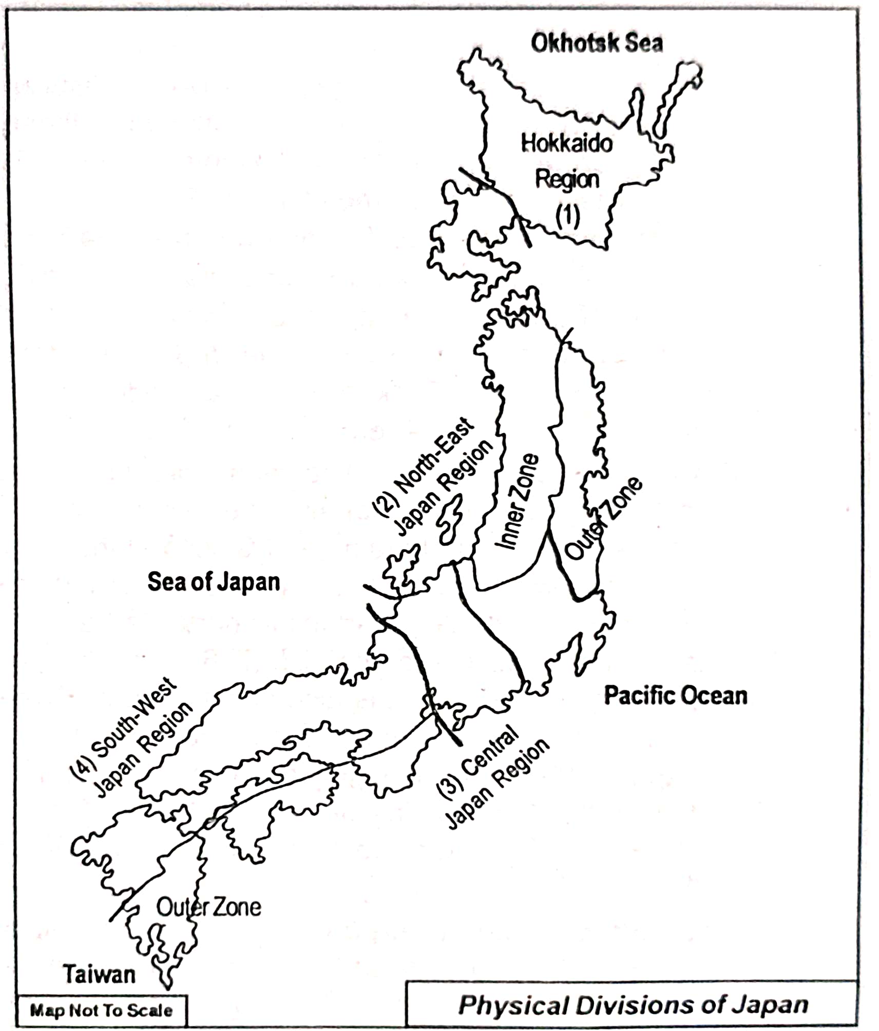
3. What are the major physical divisions of Japan? Briefly describe with map the landform of each division.
Ans. Japan is made up of a chain of islands lying in the north-western Pacific Ocean. The landform of Japan is generally similar throughout, but for convenience it is divided into four physical regions:
(i) Hokkaido region: This part covers Hokkaido Island, situated in the far north of Japan. It is mainly mountainous with the Hokkaido Range in the centre. The highest peak here is Mt. Achahidak (2,290 m). Between the mountain ranges lie wide alluvial plains like Ishikari-Yufutoh, Tsukushi and Konsen. Major towns include Sapporo, Hakodate, Muroran, Kushiro and Asahigawa.
(ii) North-east Japan region: Found in the northern section of Honshu Island, this region has many folds and faults. Two main parallel ranges—Auo and Utsu—rise here, with heights between 1,500–2,000 m. The area has volcanic peaks, lakes and coniferous forests, giving it scenic value for tourists. Plateaus here include the Kitakami Plateau (made of sedimentary rocks) and the Abukuma Plateau (largely volcanic). Important towns are Aomori, Akita, Sendai, Morioka, Koriyama and Yamagata.
(iii) Central Japan region: Located in central Honshu, this region has Japan’s loftiest mountains. Here the Honshu and Shicito-Mariana ranges join to form the country’s highest system, which includes the Hida Mountains. The famous sacred peak, Mount Fuji (3,776 m), also lies here. Fertile plains such as the Kwanto and Nobi plains make this a very productive farming region, especially with rivers like the Tone. Major cities are Tokyo, Yokohama, Nagoya and Toyama.
(iv) South-west Japan region: This division includes south-west Honshu (Chugoku-Hanshu), along with Shikoku and Kyushu islands. Its mountain systems are the longest in Japan, formed mostly of ancient rocks. Plains like Kyoto, Nara and Biwa lie between these ranges, while fertile valleys are also found. The southern part of Kyushu has several volcanoes. Leading towns in this region are Osaka, Kyoto, Kobe, Hiroshima, Nagasaki, Kitakyushu, Kagoshima, Kumamoto, Okayama and Sakai.
4. Give a brief description of the landforms of Japan.
Ans. The landforms of Japan are mostly mountainous, as about three-fourths of its total area is covered by highlands and ranges. The country is a chain of islands stretching north to south, with its terrain marked by mountains, plains, valleys and volcanic peaks. In the north, Hokkaido Island has central mountain ranges with wide alluvial plains in between. Northern Honshu (north-east Japan) has parallel mountain ranges, plateaus and volcanic landscapes. Central Honshu contains the highest mountains, including the Hida range and the famous Mount Fuji, while fertile plains like Kwanto and Nobi support dense population and agriculture. Southwestern Japan, which includes Honshu’s western part along with Shikoku and Kyushu, has long mountain systems, plains like Kyoto and Nara, and many active volcanoes, especially in southern Kyushu. Thus, Japan’s landforms are a combination of high mountains, volcanic regions, fertile plains and valleys.
5. Write briefly about population growth and distribution of Japan.
Ans. The people of Japan mainly belong to the Mongoloid race. Historical records state that the population of Japan was only about 5 million in 610 A.D. This number gradually increased to 38 million in 1880, 72 million in 1945, 127 million in 1999, and around 128 million in 2007. Due to low birth and death rates, Japan’s present annual population growth rate is only about 0.4%. It ranks as the tenth most populous country in the world.
Japan’s population is distributed very unevenly because about 75% of its land is mountainous and unsuitable for habitation, resulting in very few people living there. In contrast, the river valleys, coastal belts and plains are thickly populated. The population density in mountain regions like Hokkaido is below 100 persons per sq. km, whereas the national average is 338 persons per sq. km. Interestingly, Hokkaido covers 25% of the area of Japan but supports only 5% of its total population because of its rugged relief.
In fertile farming regions, population density is between 100–800 persons per sq. km, while in industrial plains the density rises to more than 800 persons per sq. km. About 20% of the people still live in mountainous areas. The most crowded regions are the Tokyo–Yokohama industrial belt of Central Japan and the Kobe–Osaka belt of South-west Japan, each having densities above 10,000 persons per sq. km. Tokyo alone has a population of around 3 crores, making it not only the largest city of Japan but also the most populated city in the world.
Urbanisation in Japan has increased rapidly, with 79% of the population now living in towns and cities. Migration from villages, growth of industries, and decline in agriculture have made urban regions more crowded, creating regional imbalance in population distribution.
6. Mention the factors which affect the density of population of Japan.
Ans. According to the 2007 estimate, Japan has around 128 million people, making it the tenth most populated country in the world. The population density is about 338 persons per sq.km, but it varies greatly between regions. The main reasons for this uneven population distribution are:
(i) Mountainous land: Nearly 75% of Japan is mountainous, which makes living and development difficult, so population density is below 100 persons per sq.km in these areas.
(ii) High industrialisation: Japan is highly industrialised, offering many job opportunities that attract people to urban and industrial areas, increasing population density there.
(iii) Urbanisation: Around 79% of people live in towns and cities due to better economic opportunities, causing cities to have very high population densities while rural and agricultural areas have declined.
(iv) Climate: The northern parts of Japan have very cold climates, leading to low populations, whereas coastal areas have mild climates that support higher population concentrations.
7. Write about the role of agriculture in the economy of Japan.
Ans. Japan is one of the world’s most industrialised countries, ranking second in industrial production. Still, agriculture plays a key role in its economy. About 6% of the population works in farming, and 17% of the land is used for agriculture. Japan’s agriculture is modern and highly productive due to scientific farming methods. Its contributions are:
(i) Employment: Agriculture provides jobs to thousands, reducing rural poverty and supporting the economy.
(ii) Food self-sufficiency: Unlike some industrial countries that depend heavily on imports, Japan produces most of its food, reducing reliance on other countries.
(iii) Supporting industry: Modern farming uses many machines and equipment, boosting demand and growth in industries related to agriculture.
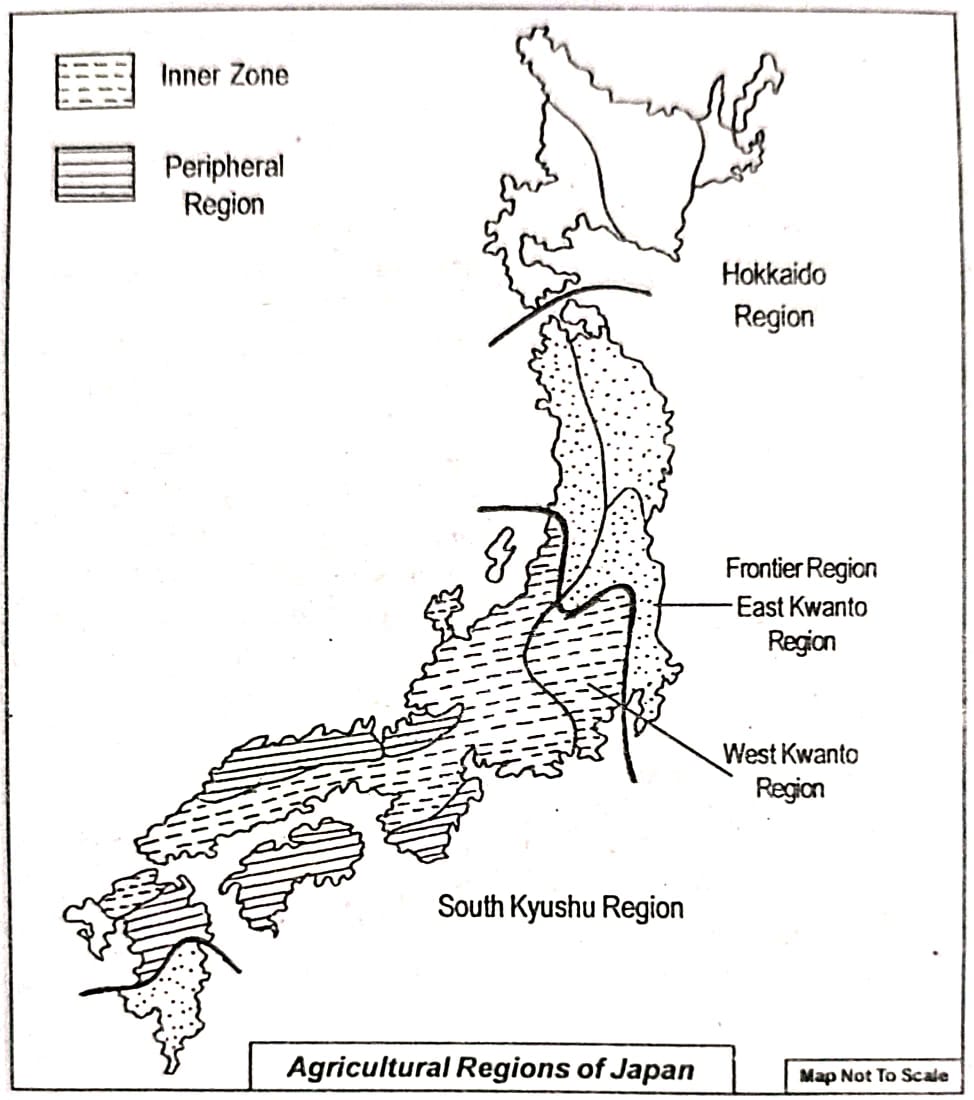
8. Show the main agricultural regions of Japan on a map and describe the main characteristics of each region.
Ans. Although nearly 75% of Japan’s land is mountainous, agriculture is practiced in many areas. About 17% of the country’s total land is under permanent cultivation, and about 6% of the population is engaged in farming. Agriculture in Japan is commercial and highly modernized, using scientific methods.
Some important features of Japanese agriculture are:
(i) Farmlands are small due to hills, mountains, and high population density.
(ii) The farms are scattered and fragmented.
(iii) Because farms are small, intensive agriculture is common, using fertilizers and modern techniques to get high yields.
(iv) Main farming methods include terrace cultivation, mixed farming, interculture farming, and shifting cultivation.
Based on farmland size, crop types and production, Japan’s agriculture is divided into two main regions:
[A] Old Japan Region
[B] Hokkaido Region.
[A] Old Japan Region: This region is further divided into three zones: inner zone, frontier zone, and peripheral zone.
(i) Inner zone: Located in central Japan, this zone has a climate suitable for growing two to three crops annually. Because of dense population, farms are small. The region is known for commercial cultivation of fruits, vegetables, flowers, and cattle rearing. Terrace farming is practiced in foothill areas.
It is subdivided into:
Sitsi-Kinki division: Included in hilly Sugoku region; rice is grown on 40% of plains. Horticulture and cattle farming are common.
North Kyushu division: Farming quality is lower but produces abundant rice in its plains.
Sukio division: Highlands are artificially irrigated for rice cultivation.
Tokai division: Warmer climate; about 45% of farming occurs on highlands. Oranges, tea, vegetables, and animal rearing are important here.
West Kanto division: Characterized by large alluvial plains; two crops are grown yearly. Produces all of Japan’s barley and one-third of its wheat; famous for mulberry trees.
Tosan division: Hilly and forested; little farming done except some rice in narrow valleys.
Hakuriko division: Known as the rice-producing zone, with high yield; 45% of rice here is grown in winter.
(ii) Frontier zone: Includes southern Kyushu and Tohoku. In southern Kyushu, farms are very small, and farming is not very developed but nearly 45% people are engaged in growing fruits and vegetables. Tohoku, in northern Honshu, has an extreme cold climate, limiting cultivation even in summer.
(iii) Peripheral zone: Comprises highlands of southern Chikoku and coastal areas. Shifting cultivation (jhum) is common here. It includes:
Central Kyushu, where rice, fruits, vegetables, and mulberry are grown extensively.
- Sunin coastal area, which is unsuitable for farming.
- Southern Chikoku, with hill slopes mostly used for shifting cultivation.
- Hida, mostly mountainous with very limited farming.
[B] Hokkaido Region: This northern agricultural zone has its main cultivation area in the Ichikari plain. Due to cold climate, only one crop is grown during summer, mostly rice. Farming is less developed because of cold weather, infertile soil, and rugged land. This region is split into Western, Central, and Eastern Hokkaido subdivisions.
9. What are the chief industrial regions of Japan? Show these regions in a map and give a brief description of each region.
Ans. Today, Japan is considered to be one of the highly industrialised nations of the world. It ranks second in industrial production in the world. In the development of science and technology, it holds the fourth position in the world. More than 40% of the national income of Japan comes from the industrial sector. More than 33% of the population of Japan is engaged in industrial activities. The industrial belt of Japan extends from Tokyo to Kyushu island- a length of about 1,000 km. This industrial belt is subdivided into the following four industrial regions:
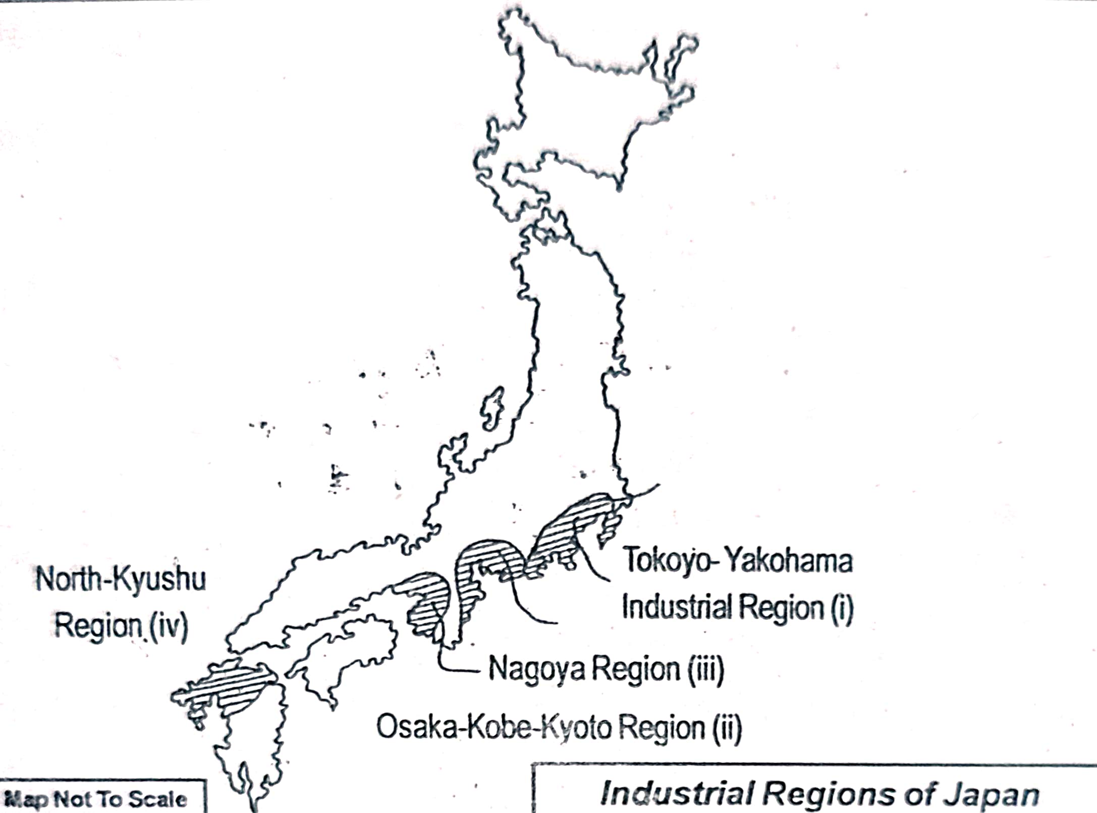
(i) Tokyo-Yakohama region: This region, situated mostly along the Tokyo Bay of the Honshu island, covers the Kanto plain. This region has ideal conditions for the industrial development. Some of the major industries that have developed here are iron and steel, shipbuilding, aircraft, chemical, textile, machinery industries, etc. This region has over 25 big and small towns. The most important among them are Tokyo and Yokohama. More than 30% of the industrial production of Japan comes from this region. Hydroelectricity is also produced here.
(ii) Osaka-Kobe-Kyoto industrial region: This industrial zone is situated in the coastal areas of Osaka Bay. It covers the Kinki plain and so this region is also known as Kinki region. The main factors that have contributed for the development of industries here are excellent water transport facilities, well-developed transport and communication system, availability of various infrastruc-tural facilities, etc. Industries such as iron and steel, petroleum, shipbuilding, aircraft manufacturing, chemical industries, etc. are the main industries that have been developed here. The important industrial towns of this region are Osaka, Kobe and Kyoto. Osaka is noted for the production of cotton and silk.
(iii) Nagoya industrial region: This industrial zone is situated on the east coast of Honshu between Tokyo-Yokohama and Osaka-Kobe-Kyoto industrial region. This region is noted for the presence of cotton, silk and woollen textile industries. This region is also known as the ‘Detroit of Japan’ as this zone has become famous for its car manufacturing industries.
(iv) North Kyushu industrial region: This industrial region mostly lies in the northern part of Kyushu island. The main reason for the development of industries here is the availability of coal and other minerals. The chief industries developed here are iron and steel, shipbuilding, cement, tools, machine manufacturing industries, etc. Yawata, Nagasaki and Shimonosoki are the main industrial centres of this region.
10. Write short Notes on:
(a) Islands of Japan.
(b) Physiography of Hokkaido region.
(c) Industrialisation and economic development of Japan.
(d) Terrace cultivation in Japan.
(e) Tokyo Yokohama industrial region.
(f) Coastal areas of Japan.
(g) Honshu island region of Japan.
(h) Mineral resources of Japan.
Ans.
(a) Islands of Japan:
Japan consists of many large and small islands in the northern Pacific Ocean. The four main islands are Hokkaido, Honshu, Shikoku, and Kyushu, with Honshu being the largest and most important, as it is the centre of industry and international trade. These islands lie mostly in the temperate zone, giving Japan a favourable climate for farming, industry, and settlement. Surrounded by seas, Japan’s fishing, shipbuilding, and trade industries have greatly benefitted.
(b) Physiography of Hokkaido region:
Hokkaido Island, located in northern Japan, is mostly mountainous with hills, valleys, and some plains. Its mountainous terrain has limited industrial and agricultural development. The central Hokkaido mountain range is prominent, with large alluvial plains such as Ishikari-Yufutoh, Tsukushi, and Konsen plains. Key towns include Sapporo, Kushiro, Muroran, Asahigawa, and Hakodate, which are relatively small compared to Honshu’s cities.
(c) Industrialisation and economic development of Japan:
Japan is one of the world’s leading industrial nations despite having few natural resources. It ranks second in industrial production and fourth in science and technology development. About 33% of its people work in industries, which generate over 40% of national income. Japan’s growth stems from its hardworking people, excellent transport and communication networks, export-oriented industrial policies, and expanding foreign trade. The main industrial belt extends from Tokyo to Kyushu, with key industries like iron and steel, textiles, shipbuilding, electrical goods, and paper manufacturing.
(d) Terrace cultivation in Japan:
Since over 75% of Japan is mountainous, terrace cultivation is practiced. This method involves cutting steps on slopes to prevent soil erosion and manage water flow. Rice and tea are the main terrace crops. The Japanese have developed a unique and advanced terrace farming technique, especially for rice on hilly slopes and foothills. Terrace cultivation is also ideal for tea, which is mostly grown on the western and eastern slopes of central and southern Honshu.
(e) Tokyo-Yokohama industrial region:
This region, situated mostly along the Tokyo Bay of the Honshu island, covers the Kanto plain. This region has ideal conditions for the industrial development. Some of the major industries that have developed here are iron and steel, shipbuilding, aircraft, chemical, textile, machinery industries, etc. This region has over 25 big and small towns. The most important among them are Tokyo and Yokohama. More than 30% of the industrial production of Japan comes from this region. Hydroelectricity is also produced here.
(f) Coastal areas of Japan:
Japan’s many islands give it an extensive coastline, crucial for its economy and industries.
(i) The long coastline helps Japan be the world’s leading producer of fish.
(ii) Coastal areas are centres of trade and business; three major industrial belts (Tokyo-Yokohama, Osaka-Kobe-Kyoto, and Nagoya) lie along the coast. These coastal regions developed industries due to easy access to imported resources and export facilities.
(g) Honshu island region of Japan:
Honshu is the largest of Japan’s four main islands and home to most of the population and industries. The western part has many folds and faults with two parallel mountain ranges, Auo and Utsu. Central Honshu contains the Honshu and Shicito Mariana mountain ranges, including the highest peak, Mount Fuji. Important plains like Kwanto and Nobi, along with rivers such as the Tone River, support large-scale agriculture. Major cities like Tokyo, Yokohama, Nagoya, and Sendai are located here.
(h) Mineral resources of Japan:
Japan has limited mineral resources. Coal reserves are low grade and insufficient, and iron ore is scarce. However, copper and sulfur deposits are available. Japan depends heavily on importing essential minerals, especially iron ore and petroleum, for its industries. The country is rich in water resources, with heavy rainfall and mountainous terrain providing excellent conditions for hydroelectric power development.
Class 10 Geography Chapter 5 – Regional Geography of Japan FAQs
Get Free NCERT PDFs
If you want to download free PDFs of any chapter, click the link below and join our WhatsApp group: