Class 10 Geography Chapter 6 – Regional Geography of India All Exercise Solutions | SEBA Assam (English Medium)
Class 10 Geography Chapter 6 – Regional Geography of India (SEBA Assam – English Medium)
The sixth chapter of SEBA Class 10 Geography, Regional Geography of India, focuses on India’s diverse geographical features and their impact on the people and economy. Being our own country, this chapter is one of the most significant portions of the HSLC Geography syllabus. It explains India’s vast physical features, varied climate, rich agriculture, mineral and industrial resources, and transport systems. This chapter also discusses population distribution and development issues that prepare students for real-world understanding as well as board exams.
✅ What You Will Learn in Chapter 6:
- India’s location, boundaries, and physical divisions
- Major rivers, mountains, and plateaus
- Climate and natural vegetation
- Agriculture – food crops, cash crops, and green revolution
- Industries – iron and steel, textile, IT, and automobile
- Mineral resources – coal, iron ore, petroleum
- Transport systems (railways, roadways, airways, waterways)
- Population and urbanization patterns
🎯 Why Choose Ospin Academy Solutions:
- Complete Class 10 Geography India chapter solutions in English
- Designed as per SEBA Assam Geography syllabus
- Textual question-answers, maps, MCQs, and HSLC important notes
- Simple explanations with exam-oriented approach
- Helpful for both assignments and HSLC exam preparation

Class 10 Geography (English Medium) HSLC 2026 Textual Solutions PDF | SEBA Assam Syllabus
Limited Time Offer!
(For HSLC Exam 2026)
Get complete preparation for Class 10 Geography (English Medium) with this all-in-one SEBA textual solution PDF.
Covers chapter-wise solutions, definitions, map work, diagrams and practical geography – fully updated for HSLC 2026 syllabus.
Perfectly designed for revision, practice and boosting exam scores!
Class 10th Geography(E)
Chapter: 6 Ospin Academy
Regional Geography of India
TEXTUAL QUESTIONS AND ANSWERS
1. Give a brief introduction to India.
Ans. India is one of the major countries in Asia, located in the northern hemisphere. It is one of the largest democracies in the world. India is known for its great diversity in physical features, races, culture, languages, religions, social customs, clothing, and food habits. The country has the snow-covered Himalayan mountains in the north and the vast sandy deserts of Rajasthan in the west. Floods happen often in many areas, while other parts face severe drought. Northern India lies mostly in the temperate climate zone, whereas the southern part is in the tropical zone. The land includes high mountains and peaks, wide plains, and extensive plateaus.
India is also diverse in races, including Austro-Asiatic, Mongoloid, Aryan, and Dravidian groups. Several religions like Hinduism, Islam, Christianity, Buddhism, Sikhism, and Jainism flourish here. Despite these differences, India shows a strong sense of national unity. This unity comes from shared physical features, the monsoon climate, an effective transport and communication system, trade and commerce, the freedom struggle, and a united administration that has grown in recent years.
2. Discuss the characteristics relating to India’s location and size.
Ans. India is located in the southern part of Asia. It is bordered by the Himalayas and China to the north, the Indian Ocean and Sri Lanka to the south, the Bay of Bengal and Myanmar to the east, and the Arabian Sea and Pakistan to the west. India stretches from Kashmir in the north to Kanniyakumari in the south, and from Arunachal Pradesh in the east to Saurashtra in the west.
The country lies between 8°4′28″N and 37°17′53″N latitudes, and between 68°7′33″E and 97°24′47″E longitudes. The Tropic of Cancer passes through India, dividing it roughly into a northern temperate zone and a southern tropical zone. The north-south length of India is about 3,214 km, while the east-west width is approximately 2,933 km. India has a coastline of around 6,100 km and a land boundary measuring over 15,200 km.
India shares land borders with six countries: Pakistan, China, Nepal, Bhutan, Myanmar, and Bangladesh. With a total area of 3,287,263 sq. km, India is the 7th largest country in the world. It accounts for 2.2% of the total land area on Earth. Currently, India is divided into 28 states and 7 union territories
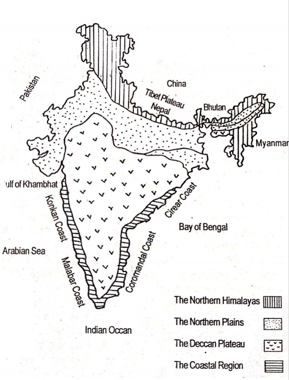
3. Into how many physiographic divisions India can be divided? Discuss with diagrams.
Ans. India has a great variety of physiographic features such as mountains, hills, valleys, plains and plateaus. Out of the total land area, about 10.7% is covered by mountains, 18.6% by hills and hillocks, 27.7% by plateaus, and 43.3% by plains. On the basis of physical characteristics, India can be divided into the following four major physiographic divisions:
(i) The Northern Himalayas:
The Himalayan region lies in the northern part of India from Nanga Parbat in Kashmir to Arunachal Pradesh in the east, stretching over 2,500 km. Its width varies between 240–500 km, covering an area of about 5,00,000 sq. km. Most peaks rise above 8,000 metres. The Himalayas, formed during the Tertiary period, are divided into three parallel ranges — the Greater Himalayas (average height 6,000 m), the Lesser Himalayas (average height 4,000 m with a width of 60–80 km), and the Outer Himalayas (average height about 1,000 m).
(ii) The Northern Plains:
Bound by the Himalayas in the north and the Deccan Plateau in the south, the northern plain extends for about 2,400 km, with a width between 240–320 km. This vast Indo-Ganga-Brahmaputra plain is further sub-divided into five parts – Western Plain, Punjab-Haryana Plain, Ganga Plain, North Bengal Plain and Brahmaputra Plain. The rivers Indus, Ganga and Brahmaputra with their many tributaries like Yamuna, Ghagra, Gandak, Kosi, Subansiri, Manas, Kapili, Sutlej, Beas and Ravi have built this fertile landmass. The Thar Desert also lies towards its western side. Known for its rich soil, this plain is one of the most populated and agriculturally productive regions of India.
(iii) The Deccan Plateau:
To the south of the northern plains lies the Deccan Plateau, formed mostly of ancient hard rocks. The Vindhya, Satpura, Mahadeo and Mahakal ranges divide it into northern and southern portions. The northern part consists mainly of Malwa and Chotanagpur plateaus, while the southern part stretches from the Vindhya-Satpura ranges to Cape Comorin (Kanyakumari). Sloping eastwards, most rivers such as the Mahanadi, Godavari, Krishna, Pennar and Kaveri drain into the Bay of Bengal, whereas the Narmada and Tapti flow west into the Gulf of Khambhat.
(iv) The Coastal Regions:
India also has coastal strips on both the eastern and western sides. The Western Coastal Plain lies between the Western Ghats and the Arabian Sea, divided into the Konkan Coast in the north and the Malabar Coast in the south. On the other hand, the Eastern Coastal Plain lies between the Eastern Ghats and the Bay of Bengal, divided into the Northern Circars in the north and the Coromandel Coast in the south. Rivers like the Godavari, Mahanadi, Krishna and Kaveri form fertile deltas on the eastern coast, whereas the western coastal strip remains narrower but more fertile.
Thus, India’s four physiographic divisions — the Himalayas, the Northern Plains, the Deccan Plateau and the Coastal Regions — together form the varied surface features of the country.
4. Describe the physiographic divisions of India.
Ans. On the basis of physical features, India can be divided into four major physiographic divisions:
The Himalayan region of India lies in the extreme north and extends from Nanga Parbat in Kashmir to Arunachal Pradesh in the east, covering about 2,500 km in length and a width ranging between 240 km and 500 km. The total area of the Himalayas is nearly 5,00,000 sq. km. On average, its peaks rise above 8,000 metres from sea level. The formation of the Himalayas began during the Tertiary period, around 7 million years ago, as a result of mountain-building activity. The Himalayas are divided into three parallel ranges running from east to west— the Great Himalayas (average height 6,000 m), the Lesser Himalayas (average height 4,000 m and 60–80 km wide), and the Outer Himalayas (average height about 1,000 m).
(ii) The Northern Plains:
Situated between the Himalayas to the north and the Deccan Plateau to the south, the northern plains stretch from Assam in the east to the Indo-Pak border in the west, extending for 2,400 km, with a width between 240–320 km. This vast plain, formed by the Indus, the Ganga, the Brahmaputra and their many tributaries, is called the Indo-Ganga-Brahmaputra plain.
The plain can be further divided into:
(a) Western Plain,
(b) Punjab-Haryana Plain,
(c) Ganga Plain,
(d) North Bengal Plain,
(e) Brahmaputra Plain.
The Ganga, originating from the Gangotri glacier, is the most important river, while the Brahmaputra starts from the Chema-yu-Dung glacier in Tibet. Their tributaries like Yamuna, Ghagra, Gandak, Kosi, Subansiri, Manas, Kapili, etc., enrich the plain. The Indus system includes Sutlej, Beas and Ravi. A small part of this division also has the Thar Desert in the west. Being very fertile, these plains are the most populated and agriculturally important region of India.
(iii) The Deccan Plateau:
Lying to the south of the northern plains, the Deccan Plateau is mainly made up of old hard rocks. The Vindhya, Satpura, Mahadeo and Mahakal ranges divide it into northern and southern sections. The northern section includes smaller plateaus like Malwa and Chotanagpur, while the southern section is larger, stretching from the Vindhya-Satpura ranges to Cape Comorin (Kanyakumari). The plateau slopes eastward, causing most rivers like Mahanadi, Godavari, Krishna, Pennar and Kaveri to flow into the Bay of Bengal. However, Narmada and Tapti rivers flow westwards and empty into the Gulf of Khambhat.
(iv) The Coastal Regions:
India has two coastal strips— one on the west and another on the east. The Western Coastal Plain lies between the Western Ghats and the Arabian Sea. Its northern part is called the Konkan Coast and the southern part is known as the Malabar Coast. On the other side, the Eastern Coastal Plain lies between the Eastern Ghats and the Bay of Bengal. Its southern part is called the Coromandel Coast, and the northern part is known as the Northern Circars. Rivers such as Mahanadi, Godavari, Krishna and Kaveri drain into the eastern coast, forming fertile deltas, though in general this region is less fertile compared to the western coastal plain.
5. Describe briefly the climatic characteristics of India.
Ans. The climate of any place is affected by several natural factors such as its size, distance from the equator, height above sea level, distance from the sea, vegetation, and winds. Similarly, the climate of India is determined by all these elements. Broadly, the climate of India is marked by the following characteristics:
(i) Varied climate:
India is a large country with different landforms like mountains, plateaus, rivers, plains and coastal areas. As a result, the country experiences a variety of climates — from snow-covered cold Himalayan regions to hot desert areas, and from rainfall-deficient zones to places with very heavy rainfall.
(ii) North-South difference:
The Tropic of Cancer divides India almost into two equal halves. The northern half lies in the temperate zone, while the southern part falls in the tropical zone. Because of this, the southern part of India generally remains warmer compared to the northern part.
(iii) Effect of altitude:
Altitude, or height from sea level, plays an important role in shaping climate. Places at higher altitudes are cooler than those at low altitudes, even if they are on the same latitude. For example, Agra and Darjeeling lie on roughly the same latitude, but due to difference in elevation, their climates are totally different.
(iv) Role of monsoon:
The monsoon is the most significant factor in India’s climate. The southwest monsoon blowing from the Arabian Sea during summer brings heavy rainfall to most parts of the country. On the other hand, in winter, the northeast monsoon causes some amount of rainfall in certain regions, especially along the eastern coast.
(v) Influence of the Himalayas:
The Himalayas have a major role in India’s climate. They act as a barrier that blocks the icy winds from Central Asia, preventing severe winters in most parts of India. Moreover, the Himalayan ranges intercept the moisture-laden winds from the Bay of Bengal and cause heavy rainfall in northern and northeastern India.
6. Explain how the monsoons affect the climate of India.
Ans. A special feature of India’s climate is the strong influence of the monsoons. In fact, monsoons are regarded as the most important element that controls the climatic conditions of our country.
During summer, the south-west monsoon winds blow from the Arabian Sea towards India. Since these winds travel over the sea, they are moisture-laden. On reaching the Western Ghats, they are forced to rise, cool down and cause heavy rainfall on the west-facing slopes. As a result, the Konkan and Malabar coasts receive very high rainfall, often exceeding 300 cm annually. After crossing the Western Ghats, these winds move over the Bay of Bengal towards Assam and the North-East. On striking the Meghalaya Plateau, they again rise and cause intense rainfall. This is why Cherrapunji in Meghalaya receives the highest rainfall in the world, around 1250 cm annually. From here, the winds spread into the plains of Assam and nearby states before being obstructed by the foothills of the Himalayas, causing further heavy rainfall in this region.
In winter, the north-east monsoon winds come from Central Asia through the passes of the Himalayas. As these winds are cold and dry, they do not bring rain to north or north-east India. But while moving towards the southern part of India, they pass over the Bay of Bengal, collect some moisture, and cause rainfall along the Coromandel Coast of Tamil Nadu.
Thus, both the summer south-west monsoon and the winter north-east monsoon play a vital role in shaping India’s climate.
7. What are the major soil types found in India? Give short description of each type of soil.
Ans. Soil is one of the most important elements of the physical environment. It influences agriculture, human settlements, vegetation, and even economic activities. India, due to its varied physiography and climate, has different types of soils. Broadly, six main categories of soil are found in India:
(i) Mountain Soils:
These soils occur in hilly and mountainous regions. Glaciers deposit sediments at the foothills, forming glacial soils. Coniferous forests often grow in such areas, and due to the decomposition of leaves mixing with the soil, it becomes acidic, known as podzol soil. Mountain soils are generally less fertile, and in foothill regions they are mostly rocky, allowing little vegetation.
(ii) Soils of the Indo-Ganga-Brahmaputra Plains:
This region is covered with alluvial soils, formed by the deposition of silt by rivers. Alluvial soils are of two types— new alluvial (khadar) and old alluvial (bangar). The new alluvial soil found in floodplains and riverbanks is fertile and rich in humus. It occurs widely in Punjab, Haryana, Uttar Pradesh, Bihar, Odisha, West Bengal and Assam. The old alluvial soil, however, is harder, poorer in fertility due to chemical changes, and often requires manures and fertilizers to regain productivity.
(iii) Desert Soils:
These soils are mainly found in the Thar Desert of Rajasthan, Saurashtra and the Rann of Kutch. Desert soils are sandy, formed through weathering processes, with high nitrogen content but very little organic matter. Hence, they usually lack fertility. However, in regions where these soils contain less salt, irrigation makes agriculture possible, and crops like wheat and barley can be grown.
(iv) Lava Soils:
Soils formed out of lava deposits are called lava soils or black soils. They cover large areas of Maharashtra, western Madhya Pradesh, Gujarat and parts of Andhra Pradesh. These soils have the capacity to retain moisture, making them well-suited for farming. Since they are particularly good for growing cotton, they are also known as “cotton soils.”
(v) Soils of the Deccan Plateau:
These soils originate from the weathering of ancient Archaean and Cambrian rocks of the plateau. They generally cannot hold water and are not naturally fertile, but with the use of fertilizers they can be improved for agriculture. Laterite soils, another type found here, are hard, reddish, and rich in iron and aluminium. Laterite soils occur in the Malabar coast, Chotanagpur plateau, Nilgiri Hills and the Western Ghats, and are well-suited for cultivating tea and coffee.
(vi) Coastal Soils:
In the coastal regions, riverine and marine processes deposit sandy and clayey materials, forming coastal soils. These soils are generally sandy and not highly fertile. However, in areas like Kerala and Karnataka, alluvial and red laterite soils are also found, which support cultivation to some extent.
8. What are the different vegetation types found in India? Mention them on a map.
Ans. The different vegetation types found in India are:
(i) Evergreen vegetation
(ii) Monsoonal vegetation
(iii) Dry thorny vegetation
(iv) Grassland vegetation
(v) Mangrove vegetation
(vi) Mountain vegetation
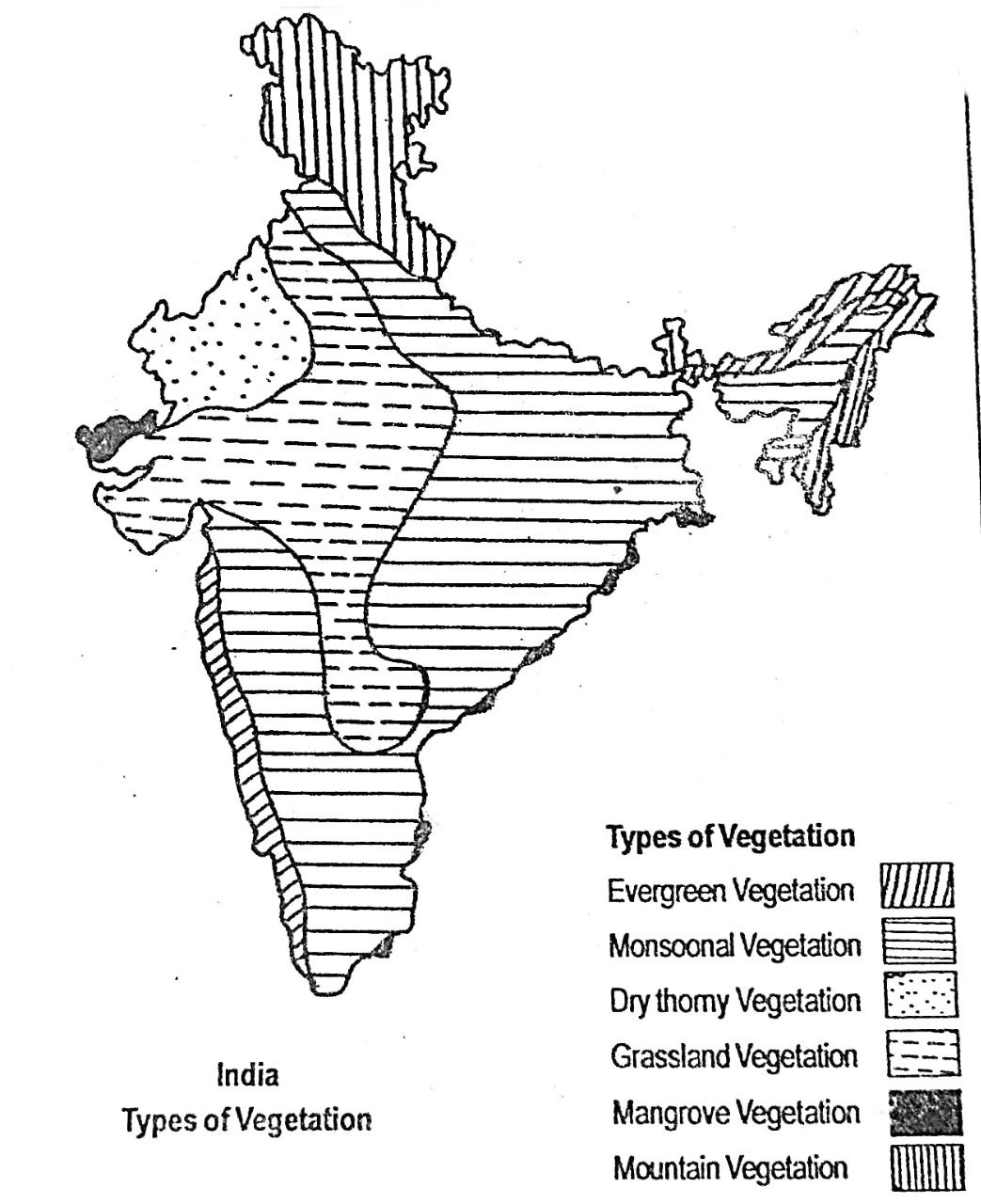
9. Describe the types of vegetation of India.
Ans. India is known for its diversity not only in landforms and climate but also in natural vegetation. Differences in soil, temperature, rainfall and relief give rise to different types of plant life in different regions. Broadly, six kinds of natural vegetation can be identified in India:
(i) Evergreen Vegetation:
These forests grow in areas with more than 200 cm rainfall annually and temperatures ranging from 25°C to 27°C. Trees are very tall, and plants such as cane, bamboo, ferns and creepers are common. Valuable trees include sisum, sandalwood and rubber. Evergreen forests are found on the western slopes of the Western Ghats, in Arunachal Pradesh, Upper Assam, the hills of Manipur and Mizoram, and the Andaman Islands.
(ii) Monsoonal Vegetation:
This is the most widespread vegetation of India. Found in regions with rainfall between 100–200 cm and average temperature around 27°C, trees of these forests shed their leaves during the dry season. Sal, teak, siris, sisu, simul and bamboo are common trees. These forests occur in Assam, Bengal, Bihar, Uttar Pradesh, Himachal Pradesh, parts of Haryana, Madhya Pradesh, Tamil Nadu, the Ghats, eastern Deccan plateau and the Andaman & Nicobar Islands.
(iii) Dry Thorny Vegetation:
This type grows where rainfall is less than 50 cm and temperatures are generally high. The sandy soil and low water content give rise to thorny plants that reduce water loss. Major species include acacia, cactus varieties and date palms. Such vegetation is mainly found in western Rajasthan (Thar Desert) and the dry parts of Punjab.
(iv) Grassland Vegetation:
India does not have extensive grasslands like the Prairies (USA) or Savannas (Africa), but smaller grasslands exist in places receiving 50–100 cm rainfall. They are found in Punjab, east Rajasthan, Uttar Pradesh plains, central Andhra Pradesh, Karnataka and parts of Maharashtra. In the Terai region of the Himalayan foothills, tall grasses like thatch, cane and reed grow in waterlogged areas, along with trees such as khoir and simul.
(v) Mangrove Vegetation:
Mangroves thrive in coastal delta regions where rivers meet the sea. They are common in the Sundarbans (delta of Ganga-Brahmaputra), the deltas of Mahanadi, Godavari, Krishna and Kaveri, as well as in the Gulf of Kutch. Trees like sundari, coconut, date palm and various bushy plants grow in these swampy, saline areas.
(vi) Mountain Vegetation:
Vegetation changes with altitude in the mountains. Up to about 1,000 m, thick monsoonal forests with abundant bamboo are found. Between 1,000–2,000 m, coniferous trees grow, especially in Kashmir, Himachal and Uttarakhand. At 1,600–3,000 m, varieties of conifers thrive, while higher up, Alpine vegetation with grasses and shrubs appears. The north-eastern hills also show rich patches of coniferous forests.
10. Write a short note on the growth of population in India.
Ans. India is the second most populated country in the world. According to the 2001 Census, the population of India was 102.7 crores. While India has about 16% of the world’s total population, it occupies only 2.2% of the world’s land area. One of the striking features of India’s population is its rapid growth, especially during the 20th century.
In 1901, the population of India was only 23.84 crores, but it rose to 102.7 crores by 2001. The decade 1991–2001 recorded the highest growth, with the population increasing from 84.63 crores in 1991 to 102.7 crores in 2001—an increase of 18.07 crores in just ten years.
Interestingly, the decade 1911–1921 showed a unique downward trend in population. The population declined slightly from 25.21 crores in 1911 to 25.13 crores in 1921. This period is often called the “year of the great divide.” Since 1921, however, the population of India has been rising continuously at a very high rate.
At present, the annual growth rate of population in India is more than 1.7%, which is higher than the world’s average of 1.2%. The main reasons behind such rapid population growth are the high birth rate, decline in death rate due to improvement in medical services, early marriage of girls, and inflow of migrants from neighbouring countries.
Population Growth in India (1901–2001):
1901 → 23.84 crores
1911 → 25.21 crores
1921 → 25.13 crores
1941 → 31.86 crores
1951 → 36.11 crores
1961 → 43.92 crores
1971 → 54.82 crores
1981 → 68.33 crores
1991 → 84.63 crores
2001 → 102.70 crores
11. “Population distribution is not uniform in all places of India”. Explain.
Ans. India is the second most populated country in the world, with 102.7 crores of people as per the 2001 Census. The country’s average population density is 324 persons per sq. km., but this figure varies widely across regions. For example, Delhi has a density of about 6,352 persons per sq. km. (2001 Census), whereas in Arunachal Pradesh it is only 13 persons per sq. km. Similarly, Uttar Pradesh has a population of more than 16.6 crores, while the Union Territory of Lakshadweep has only around 60,000 people. This clearly shows that population is distributed unevenly across India. The main factors behind this uneven distribution are as follows:
(i) Relief conditions: Plains with fertile alluvial soil and flat land (like river valleys) support dense population due to better scope for farming, settlement and transport facilities. In contrast, rugged hilly areas cannot support much agriculture or connectivity, leading to sparse settlement.
(ii) Climatic conditions: Favourable climate encourages settlement, whereas extreme heat, cold or lack of rainfall discourages it. For example, Rajasthan’s desert is sparsely populated, while the fertile and well-watered Ganga plain supports very high density.
(iii) Soil fertility: Fertile soils attract people as they are good for farming. The alluvial soils in river valleys and black soils in the Deccan plateau support crops like rice and wheat, leading to high population density. But mountain soils are less fertile, which is why upland areas remain thinly populated.
(iv) Rivers and water supply: River valleys have always attracted human settlement because water is essential for drinking, irrigation, industry and transport. This is why most early civilizations developed in river valleys.
(v) Mineral resources: Areas rich in minerals support industries and create employment opportunities. As a result, industrial belts of India are thickly populated.
(vi) Religious influence: Many people prefer to live near important religious centres such as Varanasi, Puri, Mathura and Haridwar, resulting in high population concentration in these areas.
(vii) Transport and communication: Regions with modern transport and communication facilities attract more people. This explains why towns and cities have much higher density than rural areas.
12. Discuss how population density varies in India.
Ans. A special characteristic of India’s population is its uneven density. While some regions are very thickly populated, others are sparsely populated. On the whole, the average population density of India is 324 persons per sq. km, meaning that on average 324 people live in every sq. km of land area. But this figure is only an average and it differs widely from region to region.
For instance, Delhi has a very high density of around 6,352 persons per sq. km (2001 Census), whereas Arunachal Pradesh has only 13 persons per sq. km. Similarly, Uttar Pradesh is the most populous state with more than 16.6 crore people, while the Union Territory of Lakshadweep has barely around 60,000 people. Some other densely populated areas include West Bengal, Delhi, Kerala, Chandigarh, Daman & Diu, and Puducherry. In contrast, states and union territories like Himachal Pradesh, Jammu & Kashmir, Meghalaya, Nagaland, Manipur, Sikkim, Arunachal Pradesh, Mizoram and the Andaman & Nicobar Islands have low density of population.
The main reasons for this variation in population density are:
(i) Relief features of the land,
(ii) Climatic conditions,
(iii) Soil fertility,
(iv) Availability of transport and communication facilities,
(v) Level of economic and industrial development.
Thus, the density of India’s population shows wide regional differences due to both physical and human factors.
13.Give a description of urban population of India and also present data on urban population growth in some major cities of the country.”
Ans. The population density in India’s towns and cities is very high. Factors like better transport facilities, industrial growth, modern urban services and greater job opportunities attract people from villages to settle in towns and cities. As a result, a considerable percentage of the Indian population now lives in urban areas.
According to the 1991 Census, 25.7% of India’s total population lived in urban centres, while the remaining 74.3% lived in rural areas. Along with the overall growth of population, the number of urban dwellers has also been increasing steadily. In 1981, India had about 3,245 towns and cities, and this number rose to 3,768 in 1991. Presently, India has several large metropolitan cities, and as per the 1991 Census, 13 cities had a population of over one million. Among them, Mumbai, Kolkata, Delhi and Chennai were the leading cities. Mumbai had the largest population (12.571 million), followed by Kolkata (10.916 million).
This growing trend of urban population is observed in almost all Indian states, linked mainly to industrialisation and rapid economic progress. For instance, in Assam the number of towns increased from 62 in 1981 to 87 in 1991. Guwahati is the largest city of Assam, and according to the 1991 Census, it had a population of 5.84 lakhs. Nearly 23.5% of the total urban population of Assam lived in Guwahati alone.
Population of the first ten cities of India (1991 Census):
Mumbai – 12.571 million
Kolkata – 10.916 million
Delhi – 8.375 million
Chennai – 5.361 million
Hyderabad – 4.280 million
Bangalore – 4.086 million
Ahmedabad – 3.297 million
Pune – 2.485 million
Kanpur – 2.111 million
Nagpur – 1.661 million
the fast expansion of towns and cities shows how urban population in India has been increasing rapidly due to industrialisation and economic development
14. Describe the characteristics of the major agricultural bw, regions of India.
Ans. Agriculture is the backbone of India’s economy. More than two-thirds of the people depend on it for their livelihood. It not only provides food for over one billion people but also earns foreign exchange and supports various agro-based industries. On the basis of cultivation patterns, India can be divided into the following major agricultural regions:
(i) Fruits and Vegetables Region:
This belt extends from Kashmir to the north-east of India. Rainfall ranges from about 60 cm in the north-west to around 200 cm in the east. The climate is favourable for growing fruits like apples, peaches, cherries, plums, apricots and oranges. Vegetables such as potatoes and chillies are also widely grown here.
(ii) Rice-Jute-Tea Region:
India ranks among the leading rice producers of the world. The main rice-growing areas include Assam, Arunachal Pradesh, Tripura, Meghalaya, West Bengal, Odisha, northern and eastern Bihar and the Terai region of Uttar Pradesh. Fertile river valleys here are best suited for rice. Tea is grown mainly in the upper Brahmaputra valley of Assam, Tripura and north Bengal, while jute is cultivated in Assam, the Ganga plain, the delta region and the eastern coast. Other crops include mustard, pulses, coconut, mango, pineapple, jackfruit and oranges.
(iii) Wheat and Sugarcane Region:
This region covers northern Bihar, Uttar Pradesh, Punjab, Haryana, western Madhya Pradesh and northern Rajasthan. Rainfall is moderate but irrigation supports farming. Wheat and sugarcane are the dominant crops, especially in Uttar Pradesh, Bihar plains and the Ganga-Yamuna Doab. Punjab, Haryana and northern Rajasthan are also major wheat-producing areas. Besides these, maize and pulses are also cultivated.
(iv) Millets and Oilseeds Region:
This zone includes the Karnataka plateau, parts of Tamil Nadu, southern Andhra Pradesh and eastern Kerala. With annual rainfall of 75–125 cm, it is suitable for growing millets like bajra, ragi and jowar, as well as oilseeds like groundnut and mustard. Mangoes and bananas are also widely produced here.
(v) Maize and Coarse Crops Region:
This region covers western Rajasthan, semi-arid Gujarat and the desert areas of western India. Rainfall here is only about 50 cm. The eastern parts with alluvial soils support crops like wheat and ragi, while maize is grown widely in the drier western part. Cotton, sugarcane, rice and bajra are also cultivated in some parts on a smaller scale.
(vi) Cotton Region:
The Deccan plateau is ideal for cotton cultivation because of its black soil. It mainly covers Gujarat and Maharashtra. The region lies in the rainshadow of the Western Ghats, so rainfall is limited, but black soil retains moisture. Cotton is the main crop, though sugarcane, wheat, jowar, bajra and gram are also grown.
(vii) Spices and Plantation Crops Region:
This region extends over most parts of the coastal plains (east and west), Andaman & Nicobar Islands, and Lakshadweep. With more than 250 cm of rainfall, it is well suited for plantation crops. Major items are coffee, tea, rubber, tapioca, pepper and cardamom, while rice is also grown in some areas.
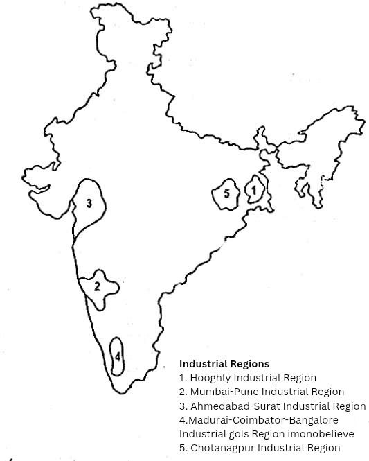
15. Locate the major industrial regions of India on a map and describe each of them briefly.
Ans. India today is among the rapidly industrialising nations of the world. Much of the economic progress of the country has been achieved through industrialisation in the last few decades. On the basis of industrial growth, India can be divided into the following major industrial regions:
(i) Hooghly Industrial Region:
Located around Hooghly and Kolkata in West Bengal, this region was once the centre of jute and engineering industries. Major industrial centres here include Naihati, Jagatdal, Shamnagar, Tribeni, Belur, Liluah and Andul. However, after partition, shortage of raw materials badly affected the industries. Today, labour unrest, shortage of power supply and lack of capital are some of the obstacles in further growth.
(ii) Mumbai–Pune Industrial Region:
This region is India’s most important centre for cotton textile industries. It includes industrial centres like Mumbai, Vile Parle, Thane, Bhandup and Pune. In recent decades, the discovery of oil at Bombay High has encouraged new industries like petrochemicals, oil refineries and synthetic fibres. Today, Pune has grown as a hub for chemical, automobile and engineering industries. Good capital investment and availability of skilled labour have helped this region diversify rapidly.
(iii) Ahmedabad–Surat Industrial Region:
Situated in Gujarat, this belt around Ahmedabad and Surat has developed industries such as petrochemicals, fertilizers, synthetic fibres, diamonds, and chemicals. Although the region started mainly with cotton textile industries, it has now shifted more towards chemical-based industries due to the discovery of natural oil and gas in the state.
(iv) Madurai–Coimbatore–Bangalore Industrial Region:
This is the most important industrial belt of South India, known especially for cotton textile industries. In addition, several government-controlled industries such as Indian Telephone Industry, machine tools industry and aeronautics have been established here. Bangalore has further grown in importance as a centre of electronics and information technology.
(v) Chotanagpur Industrial Region:
This region has developed mainly due to the rich reserves of coal and iron ore found here. It is the major centre of iron and steel industries in India. Cities like Jamshedpur, Bokaro and Durgapur are famous for steel plants. Apart from iron and steel, other industries like engineering, cement and chemicals have also developed considerably in this region.
16. Write short notes on the on the following:
(a) The north Indian pain region.
(b) Importance of agriculture in Indian economy.
(c) Monsoon vegetations.
(d) Monsoons, and rainfall in India.
(e) Causes of population growth in India.
(f) Causes, responsible for uneven distribution population in India.
(g) Lava soils.
(h) Hooghly industrial region.
(i) Characteristics of the north Indian rivers.
(j) Characteristics of the south Indian rivers.
(k) Indian islands.
(l) The Himalayan mountain region.
Answer:
(a) The North Indian Plain Region The North Indian Plain is a vast and fertile stretch of land lying between the Himalayan mountains in the north and the Peninsular Plateau in the south. It extends across several states like Punjab, Haryana, Uttar Pradesh, Bihar, and West Bengal. Formed by the deposition of alluvium brought down by rivers like the Ganga, Yamuna, Brahmaputra, and their tributaries, this region is one of the most agriculturally productive in India. The plains are flat and low-lying, making them ideal for transportation and irrigation. The climate, fertile soil, and availability of water make it a densely populated region.
(b) Importance of Agriculture in Indian Economy Agriculture is the backbone of the Indian economy. It employs over 50% of the population and contributes significantly to the country’s GDP. Agriculture supports industries by providing raw materials like cotton, jute, and sugarcane. It is also vital for food security and contributes to exports, helping in earning foreign exchange. The agricultural sector also influences rural livelihoods and plays a central role in socio-economic development. Programmes like the Green Revolution and various government schemes aim to improve productivity and farmer income.
(c) Monsoon Vegetations
Monsoon vegetation refers to the natural plant life that grows in regions influenced by the seasonal monsoon climate. In India, this type of vegetation is found in areas receiving high rainfall, typically during the southwest monsoon. These include tropical deciduous forests, which are also known as monsoon forests. Common trees include sal, teak, bamboo, neem, and mahua. In dry months, these trees shed their leaves to conserve water. Monsoon vegetation supports a wide range of wildlife and contributes to biodiversity and the environment.
(d) Monsoons and Rainfall in India Monsoons are seasonal winds that bring significant rainfall to India, especially during June to September. The southwest monsoon, originating from the Indian Ocean, causes heavy rainfall on the western coast, northeast, and northern plains. The retreating or northeast monsoon affects the southeastern coast, particularly Tamil Nadu. Rainfall in India is highly uneven and varies from region to region. While areas like Meghalaya receive over 11,000 mm of rain annually, regions like Rajasthan remain arid. Monsoons influence agriculture, water supply, and the economy.
(e) Causes of Population Growth in India India’s rapid population growth is due to several reasons:
1. Decline in death rate due to improved medical facilities and sanitation.
2. High birth rate, especially in rural areas, due to lack of awareness and social factors.
3. Early marriage and large family norm among many communities.
4. Lack of family planning education and access to contraceptives.
5. Improved living conditions, which have increased life expectancy. This population growth puts pressure on resources, leading to problems like unemployment, poverty, and environmental degradation.
(f) Causes Responsible for Uneven Distribution of Population in India Population in India is unevenly distributed due to:
1. Geographical factors: Fertile plains (like the Ganga basin) are densely populated, while deserts and mountains have sparse population.
2. Climate: Regions with moderate climate attract more people, unlike extremely hot, cold, or arid areas.
3. Soil fertility: Agricultural regions have more population.
4.Water availability: Areas near rivers and lakes are more densely populated.
5. Industrial development: Regions with industries and job opportunities, like Mumbai or Bangalore, have dense populations.
6. Transport and infrastructure: Well-connected areas have higher population density.
(g) Lava Soils (Black Soils) Lava soils, also known as black soils or regur soils, are formed from volcanic lava rocks. They are mostly found in the Deccan Plateau covering Maharashtra, Madhya Pradesh, Gujarat, and Andhra Pradesh. These soils are dark in color, rich in minerals like iron, magnesium, and lime. They have excellent moisture retention capacity, making them ideal for cotton cultivation. Black soils crack in dry seasons but swell when wet, which helps in natural irrigation. They are also suitable for crops like soybean, pulses, and oilseeds.
(h) Hooghly Industrial Region The Hooghly Industrial Region is one of the oldest industrial belts in India, located along the banks of the Hooghly River in West Bengal. It includes cities like Kolkata, Howrah, and Haldia. This region developed due to factors like proximity to the Kolkata port, availability of cheap labor, good transport facilities, and British investment during colonial rule. Major industries include jute, textiles, chemicals, engineering, and shipbuilding. The region also has oil refineries and paper mills. However, some industries here face challenges due to outdated technology and competition.
(i) Characteristics of the North Indian Rivers 1. Originate from the Himalayas and are mostly perennial (flow throughout the year).
2. Fed by both rainwater and melting glaciers.
3. Flow over long distances, forming large plains and depositing alluvial soil.
4. Create fertile floodplains, supporting agriculture.
5. Form meanders, ox-bow lakes, and deltas.
6. Examples include the Ganga, Yamuna, Brahmaputra, and their tributaries. These rivers are crucial for irrigation, drinking water, transport, and religious significance.
(j) Characteristics of the South Indian Rivers 1. Originate from the Western Ghats or central highlands.
2. Mostly rain-fed, hence seasonal and may dry up in summer.
3. Flow through plateau regions with higher gradients and shorter courses.
4. Create waterfalls and are used for hydroelectricity (e.g., Jog Falls).
5. Do not form large deltas like northern rivers, though some like Godavari and Krishna do.
6. Important rivers include Godavari, Krishna, Kaveri, and Mahanadi. They are important for irrigation, water supply, and hydro-power generation.
(k) Indian Islands India has two main island groups:
1. Andaman and Nicobar Islands in the Bay of Bengal.
2. Lakshadweep Islands in the Arabian Sea.
Andaman and Nicobar Islands are volcanic in origin, forested, and have strategic importance. They are rich in biodiversity and attract tourists. Port Blair is the capital.
Lakshadweep Islands are coral islands, flat and sandy, known for coconut cultivation and marine resources. Kavaratti is the capital.
These islands help in extending India’s maritime boundary and play a key role in defense and oceanic studies.
(l) The Himalayan Mountain Region The Himalayas are the highest mountain range in the world, stretching across the northern boundary of India. They are divided into three parallel ranges: the Greater Himalayas (Himadri), the Lesser Himalayas (Himachal), and the Shivalik Hills. The Himalayas act as a natural barrier protecting India from cold Central Asian winds. They are the source of many perennial rivers like the Ganga and Yamuna. The region is rich in biodiversity and forest resources. It also plays a significant role in influencing India’s climate and monsoon pattern and holds great religious and cultural significance.
Class 10 Geography Chapter 6 – Regional Geography of India FAQs
Get Free NCERT PDFs
If you want to download free PDFs of any chapter, click the link below and join our WhatsApp group: