Class 10 Social Science Chapter 12 – Lifelines of National Economy Solutions | NCERT | CBSE Board (English Medium)
Class 10 Social Science Chapter 7 – Lifelines of National Economy (NCERT Solutions for CBSE Board – English Medium)
This chapter from Contemporary India – II (Geography) highlights the importance of transport, communication, and trade in the economic development of India. It explains how roadways, railways, waterways, airways, and pipelines connect different regions of the country. It also discusses modern communication systems and India’s role in international trade and globalization.
✅ What You Will Learn:
- Importance of transport and communication for economic growth
- Different means of transport – road, rail, water, air, and pipelines
- Role of communication systems – postal services, telecommunication, internet, radio, TV
- International trade and globalization impacts on India’s economy
- Map-based understanding of major ports, airports, and trade routes
🎯 Ospin Academy Advantages:
- Complete NCERT Solutions for Geography Chapter 7 with diagrams and maps
- Prepared strictly as per CBSE Class 10 Board Exam 2025 pattern
- Short, long, and map-based answers for exam preparation
- Important previous year board questions added
- Simple, exam-focused explanations with real-life examples
Class 10 Social Science (CBSE 2025) | English Medium Chapter-wise Solutions PDF
Board Exam Special!
(For CBSE Class 10, 2025)
Master Class 10 Social Science (English Medium) with this chapter‑wise solutions PDF.
Covers History, Geography, Civics & Economics as per latest NCERT syllabus.
Perfect for self-study, revision, and CBSE 2025 exam preparation.
Chapter 7
Lifelines of National Economy
Exercises
Q.1A Which two of the following extreme locations are connected by the east-west corridor?
A. Mumbai and Nagpur
B. Silcher and Porbandar
C. Mumbai and Kolkata
D. Nagpur and Siligudi
Ans.: The East- West corridor starts at sirampur in Porbandar to the West and connects Silchar in the East.
Q.1B Which mode of transportation reduces trans-shipment losses and delays?
A. Railways
B. Roadways
C. Pipeline
D. Waterways
Ans.: The pipeline mode is used for transporting liquids and gases. It effectively reduces the costs and the deklays.
Q.1C Which one of the following states is not connected with the H.V.J. pipeline?
A. Madhya Pradesh
B. Maharashtra
C. Gujarat
D. Uttar Pradesh
Ans.: HVJ is an abbreviation for Hazira- Vijaypur- Jagdishpur. It is connected in the states of Gujrat, Madhya Pradesh, Rajasthan, Haryana and NCT.
Q.1D Which one of the following ports is the deepest land-locked and well protected port along the east coast?
A. Chennai
B. Paradip
C. Tuticorin
D. Vishakhapatnam
Ans.: Vishakhapatnam is the only major port in Andhra Pradesh and India’s second largest by volume of cargo handeled.
Q.1E Which one of the following is the most important mode of transportation in India?
A. Pipeline
B. Railways
C. Roadways
D. Airways
Ans.: Roadways is the cheapest and most popular mode of transport in India.
Q.1 F Which one of the following terms is used to describe trade between two or more countries?
A. Internal trade
B. International trade
C. External trade
D. Local trade
Ans.: Internal trade refers to trade within the Nation. External trade refers to trade between foreign countries and local trade refers to trade with small areas of a nation. While International trade constitutes the trade between one nation and the other.
Q.2A Answer the following questions in about 30 words. State any three merits of roadways.
Ans.: Three merits of roadways are:
(a) Constructing roadways is cheaper.
(b) Roadways connects door to door thus minimal cost of loading and unloading.
(c) Provides facility to reach other modes of transport like railway stations, ports etc.
Q.2B Answer the following questions in about 30 words.
Where and why is rail transport the most convenient means of transportation?
Ans.: Rail transport constitutes the most convenient mode of transport in the Northern plains because of the vast level and high population density. These conditions promote railways.
Q.2C Answer the following questions in about 30 words.
What is the significance of the border roads?
Ans.: The significance of border roads:
(a) Border roads have improve the accessibility in areas of difficult terrain mainly the Northern and North Eastern border areas of India.
(b) These roads serve in the economic development of these areas.
Q.2D Answer the following questions in about 30 words.
What is meant by trade? What is the difference between international and local trade?
Ans.: Trade refers to the exchange of goods among people, states and countries.
International trade refers to Trade between two or more. Trade that occurs-in-a region within the same country is called local trade.
Q.3A Answer the following questions in about 120 words.
Why are the means of transportation and communication called the lifelines of a nation and its economy?
Ans.: A country’s progress completely relies on the transportation and communication. Goods which are produced in one part of the nation needs to be transported from one part of the country to the other. Therefore transport plays an important role in the progress of country’s economy. Transportation is the pre requisite for delivering the raw materials to the site of production, and for the delivery to finished goods to the consumer. Hence, for the production as well as distribution good transportation system is necessary.
Trade in India is working efficiently because of it’s appreciable connectivity. India is well-linked with the rest of the world via railways,
airways, waterways, newspapers, radio, television, cinema and internet, etc. They have been contributing to its socio economic progress in many ways. International and local trade both have contributed to the development of the country. Hence, we can say that means of transportation and communication are the lifelines of a nation and its economy.
Q.3B Answer the following questions in about 120 words.
Write a note on the changing nature of the international trade in the last fifteen years.
Ans.: International trade is defined as the exchange of goods and services between two or more nations. International trade has experienced a huge change in the past 15 years. Along with the exchange of goods and services exchange of knowledge has superseded our nation. India has emerged as a software giant at the international level and it is earning huge foreign exchange through the export of information technology. Economic prosperity of a country is evaluated on the basis of the advancement of international trade of the nation. It is, therefore, considered the economic barometer for a country. Income from International trade constitutes a huge share in the economic development.
Major Exports
● agricultural and allied products-2.53%
● ores and minerals-9.12%
● gems and jewellery-26.75
● chemical and allied products-24.45%
● engineering goods-35.63%
● petroleum products-86.12%
Major Imports
● petroleum and petroleum products-41.87%
● pearls and precious stones-29.26%
● inorganic chemicals-29.39%
● coal, coke and briquettes-94.17%
● machinery- 12.56%
● Bulk imports include fertilisers-67%, cereals-25.23%, edible oils 7.94% and newsprint-5.51. India has trade relations with all the major trading blocks and all geographical regions of the world.
Quiz Drive
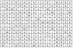
Q.1 Northern terminal of the North-south corridor.
Ans.: SRINAGAR: is the Nothern terminal for the North- South corridor and Kanyakumari is the Southern terminal.
Q.2 The name of National Highway No. 1.
Ans.: SHER SHAH SURI MARG: is known as the NH- 1. It runs from Delhi to Amritsar.
Q.3 The headquarter of the southern railway zone.
Ans.: CHENNAI: is the headquarter of the southern railway zone
Q.4 The rail gauge with a track width of 1.676 m.
Ans.: BROAD GAUGE: is the rail gauge with a track width of 1.676 m.
Q.5 The southern terminal of the National Highway No. 7.
Ans.: KANYAKUMARI: is the sothern terminal of the North- South corridor i.e. NH- 1
Q.6 A Riverine Port.
Ans.: KOLKATA: is an example of a riverine port
Q.7 Busiest railway junction in Northern India.
Ans.: MUGHALSARAI: is the busiest railway junction in Northern India.
Activity:
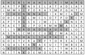
Q.1 Start your search vertically, horizontally or diagonally and reach various destinations across the countries!

Ans.:

1. SRINAGAR is the Nothern terminal for the North- South corridor and Kanyakumari is the Southern terminal.
2. SHER SHAH SURI MARG is known as the NH- 1. It runs from Delhi to Amritsar.
3. CHENNAI is the headquarter of the southern railway zone 4. BROAD GAUGE is the rail gauge with a track width of 1.676 m.
5. KANYAKUMARI is the sothern terminal of the North- South corridor i.e. NH- 1
6. KOLKATA is an example of a riverine port
7. MUGHALSARAI is the busiest railway junction in Northern India.
Class 10 Social Science Chapter 12 – Frequently Asked Questions
Get Free NCERT PDFs
If you want to download free PDFs of any chapter, click the link below and join our WhatsApp group:

