
Class 8 Social Science Chapter 7 – Rivers of Assam – All Textual Solutions | ASSEB Assam (English Medium)
Class 8 Social Science Chapter 7 – Rivers of Assam Complete Textual Questions and Answers Solutions (ASSEB / SEBA Assam – English Medium)
Chapter 7 ‘Rivers of Assam’ from the Geography section of the Class 8 Social Science curriculum is a crucial lesson for students. Based on the new ASSEB (Assam State School Education Board) curriculum and the latest guidelines of the National Education Policy (NEP), comprehensive textual question answers for this chapter have been prepared. This special collection includes Very Short Answer (VSA) questions, Short Answer questions, Long Answer questions, and detailed textbook solutions. At Ospin Academy, these solutions are presented in a simple, accurate, and fully exam-oriented format.
The lesson ‘Rivers of Assam’ provides a detailed geographical study of the extensive river systems shaping the state, primarily focusing on the mighty Brahmaputra and the Barak rivers along with their numerous north-bank and south-bank tributaries. Understanding the core themes, origin points, drainage basins, and significance of these rivers is highly essential for school examinations. Our textual solutions cover not only the textbook exercise questions but also extra important questions and answers that may appear in the exams, ensuring students can prepare thoroughly.
What you will learn and get from these textual solutions:
- Detailed insights into the Brahmaputra river system, its origin (Chemayungdung glacier), course, major tributaries (like Subansiri, Manas, Kameng, Dhansiri), and island formations including Majuli.
- Flawless answers for 1-mark Very Short Answer (VSA objective type) questions and 2-3 mark short questions suitable for exams.
- Standard and easy-to-understand solutions for 4-5 mark long answer questions explaining the Barak river system and its economic importance.
- Clear explanations of the impact of these rivers on Assam’s agriculture, transport, economy, as well as the annual challenges of floods and bank erosion.
- Important chapter-end questions along with solutions for the latest pattern Multiple Choice Questions (MCQs) according to the new syllabus structure.
Key features of Ospin Academy’s questions and answers:
- Complete textual solutions prepared strictly according to the latest ASSEB new syllabus.
- 100% accurate, high-quality notes written in simple English language making it easy for students to memorize and understand (Class 8 Social Science Notes).
- Concise and straightforward answers specially curated for quick revision before examinations.
- A special compilation of extra important exam-oriented questions from the Rivers of Assam chapter.
Keeping in mind the academic enhancement of students, Ospin Academy provides these premium textual solutions. Start your preparation today and head towards scoring maximum marks in your Social Science subject.

Class 8 Social Science (English Medium) PDF Solutions 2026-27 | SCERT Assam
Download Class 8 Social Science (English Medium) PDF with chapter-wise MCQs, textbook answers, and extra questions for SCERT Assam 2025-26.
Class 8 Social Science
Chapter – 7 (Ospin Academy)
Rivers of Assam
|
Exercise |
|---|
1. Write answers.
(a) Name the glacier which is the source of the Brahmaputra river.
Ans: The glacier that is the source of the Brahmaputra River is the Angsi Glacier, located on the northern side of the Himalayas in Tibet.
(b) What is the total length of Brahmaputra river?
Ans: 2,900 km.
(c) In which country is the source of the Brahmaputra river.
Ans: The river originates from the Kailash ranges of Himalayas at an elevation of 5300 M.
(d) What is the shape of a river in the upper course?
Ans: The upper course of the river helps to create V-shaped valleys, waterfalls, rapids and gorges.
(e) Name the countries through which the Brahmaputra flows.
Ans: Tibet(China), India, and Bangladesh.
2. Write the correct answer.
(a) Canyons are geographical features found in the Sower /mouth course of a river.
Ans: Middle
(b) Braided rivers are generally seen in mountains/ plains/plates.
Ans: Mountains.
(c) Flood plains are formed due to river erosion/ transportation /deposition.
Ans: Deposition.
(d) The river Barak flows through 2/3/4 districts of Assam.
Ans: 4.
3. Match.
|
Arunachal |
Zig- zag path |
|---|---|
|
Tsangpo |
Majuli |
|
Meandering |
Sing |
|
Kollong |
Tibet |
|
River island |
Suit (branch) |
Ans:
|
Arunachal |
Zig- zag path |
|---|---|
|
Tsangpo |
Sing |
|
Meandering |
Tibet |
|
kollong |
Suit (branch) |
|
River island |
Majuli |
4. Write short notes.
(a) Work of a river in the upper course.
Ans: Erosion Rivers in the upper course primarily erode their channels through three main processes: hydraulic action (force of water against the river banks), abrasion (where rocks and sediment wear down the riverbed), and attrition (where rocks and sediment collide and wear each other down).
(b) Work of a river in the middle course.
Ans: In the middle course of a river, the main work includes erosion, transportation, and deposition. The river erodes its banks and bed, carrying sediment downstream. It forms meanders and occasionally oxbow lakes.
(c) Work of a river in the lower course.
Ans: In the lower course, the river’s work primarily involves deposition. The river slows down, depositing sediment it has carried from the upper course. It forms floodplains, deltas, and distributaries as it approaches the sea.
(d) Course of Barak river.
Ans: The Barak River originates in the Manipur Hills of India and flows through the states of Manipur, Nagaland, Mizoram, and Assam. It eventually enters Bangladesh, where it is known as the Surma River. In Bangladesh, it joins with the Kushiyara River and continues as the Meghna River, which empties into the Bay of Bengal. The Barak River system is significant for its role in the drainage and agriculture of northeastern India and Bangladesh.
5. Why most of the courses of Brahmaputra Zig-zag?
Ans: The Brahmaputra River tends to have a zig-zag course due to the nature of its flow through the Himalayan terrain. It encounters various geological formations and resistant rock structures, which deflect its flow and create meanders.
6. By what names is the Brahmaputra known from its source to mouth.
Ans: The river originates from the Kailash ranges of Himalayas at an elevation of 5300 M. After flowing through Tibet it enters India through Arunachal Pradesh and flows through Assam and Bangladesh before it joins Bay of Bengal. The catchments area of Brahmaputra in Tibet is 2, 93,000 Sq.
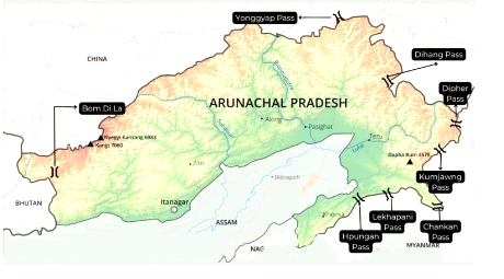
7. Draw a sketch of North-east India and with the help of an atlas, insert the following:
1. Arunachal Himalaya.
Ans:
2. Barail Mountain.
Ans:Do yourself.
3. Karbi plateau.
Ans: Do yourself.
4. Khasi Jaintia Hills.
Ans: Do yourself.
5. Naga Hills.
Ans: Do yourself.
6. Manipur.
Ans: Do yourself.
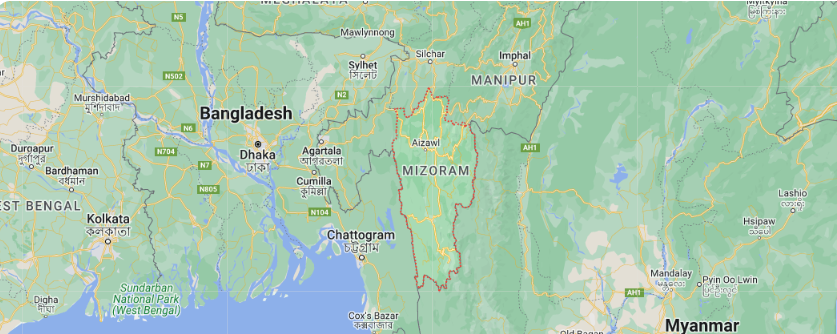
7. Mizoram.
Ans: Do yourself.
8. Garo Hills.
Ans:
9. Brahmaputra.
Ans: Do yourself.
10. Subansiri.
Ans: Do yourself.
11. Dibang.
Ans: Do yourself.
12. Lohit.
Ans: Do yourself.
13. Pagladia.
Ans: Do yourself.
14. Manas.
Ans: Do yourself.
15. Dikhow.
Ans: Do yourself.
16. Dhansiri.
Ans: Do yourself.
17. Barak.
Ans: Do yourself.
18. Jatinga Tributary.
Ans: Do yourself.
19. Dhaleswari.
Ans: Do yourself.
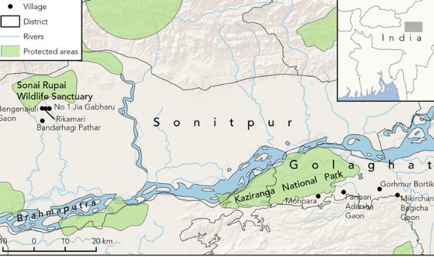
20. Sonai.
Ans:
8. Write about the tributary. relationship between river and people living river or a bank of a Assam
Ans: The relationship between rivers and the people living along their banks in Assam, like in many other regions, is deeply intertwined and multifaceted.
Here are some key aspects of this relationship:
(i) Water Source and Livelihood: Rivers in Assam, such as the Brahmaputra, Barak, and their tributaries, are crucial water sources. They support agriculture through irrigation, fishing, transportation, and domestic use. Many communities depend directly on river water for their daily needs and economic activities.
(ii) Fertile Soil and Agriculture: Riverbanks in Assam are typically fertile due to regular deposition of silt during floods. This makes them ideal for agriculture, particularly for growing rice and other crops. Farmers rely on the river’s natural cycles of flooding and receding waters to rejuvenate their fields.
9. Collect pictures an album of flood and erosion published in newspapers, magadines, etc. and make.
Ans: Do yourself.
10. Write the names of the tributaries on the north bank of the Bharmaputra from Guwahati to Dibrugarh. If needed, take help from your teacher or an atlas.
Ans: The names of the tributaries on the north bank of the brahmaputra from Guwahati to Dibrugarh are mentioned below:
(i) Subansiri River: It joins the Brahmaputra near North Lakhimpur.
(ii) Dikhow River: Enters the Brahmaputra near Dibrugarh.
(iii) Disang River: Joins the Brahmaputra near Moran.
(iii) Dhansiri River: Enters the Brahmaputra near Tezpur.
(iv) Jia Bharali River: Joins the Brahmaputra near Tezpur.
(v) Puthimari River: Enters the Brahmaputra near Guwahati.
