Class 10 Social Science Chapter 8 – Geography of the World Complete Question Answer | ASSEB / SEBA
Class 10 Social Science (Geography) Chapter 8 – Geography of the World Complete Question Answers and Exam Solutions (ASSEB / SEBA Assam – English Medium)
The eighth chapter of the Class 10 Social Science syllabus, ‘Geography of the World’ (World Geography), is a vast and fascinating chapter that broadens a student’s global perspective. For the upcoming HSLC 2027 board examinations, we have systematically compiled a complete set of question answers (Class 10 Social Science Chapter 8 Question Answer) perfectly aligned with the New ASSEB (Assam State School Education Board) Syllabus 2026-27 and the latest exam blueprint. This comprehensive Question Bank includes in-text Very Short Answers (VSA), Short Questions, Long Answers, and detailed solutions to Previous Years’ Board Exam Questions (PYQ). Ospin Academy delivers these materials with absolute precision to elevate your exam preparation.
This chapter provides a detailed geographical overview of the Earth, including the distribution of continents and oceans. It delves into the specific physical features, climate, natural vegetation, and countries of major continents like Asia, Europe, Africa, North America, South America, Oceania, and Antarctica. Memorizing continental boundaries, major mountain ranges, and rivers is highly crucial for board examinees. Our Question Bank ensures that you not only master the textbook exercises but also tackle the Extra Board Questions and Answers that frequently appear in the HSLC exams.
What you will learn and get from this chapter:
- A clear understanding of the Earth’s lithosphere and hydrosphere, and the general distribution of land and water.
- Detailed physical geography, including major rivers, mountains, and deserts of all seven continents.
- Perfectly structured answers for 1-mark objective questions (VSA/MCQ) related to geographical facts and locations.
- Point-wise, easy-to-memorize solutions for 2-3 marks short notes and 4-5 marks long descriptive questions.
- A thorough map-pointing guide and conceptual clarity for both regional and physical world geography.
Special benefits from Ospin Academy for the HSLC 2027 Exam:
- A fully updated Chapter 8 Question Bank perfectly mapped to the new ASSEB blueprint for HSLC 2027.
- Verified and detailed solutions for Previous 10 Years’ Questions (PYQ) along with Pre-Board papers from multiple districts of Assam.
- 100% accurate, high-quality study materials (Class 10 Geography Notes) written in simple English to facilitate rapid learning.
- Easily downloadable PDF format (PDF Download) optimized for smart, last-minute revision before the board exam.
- An expertly curated list of 100% Common Board Suggestion questions to maximize your scoring potential.
Broaden your geographical knowledge and secure the Highest Marks in Social Science by starting your HSLC 2027 exam preparation with Ospin Academy today.
Class 10 Social Science Question Bank ASSEB HSLC 2027 | English Medium Chapter-wise Solutions PDF

Class 10: Social Science
Geography of the World
HSLC English PYQs (2024–2026): Important MCQs with Answers
1. Match the following and choose the correct option : {2026}
(i) Pacific Ocean
(ii) Asia
(iii) Atlantic Ocean
(iv) North America
(A) Colorado – desert like area
(B) Labrador Sea
(C) Alaska Sea
(D) Mongolian Plateau
(A) (i) – (B), (ii) – (C), (iii) – (D), (iv) – (A)
(B) (i) – (C), (ii) – (D), (iii) – (B), (iv) – (A)
(C) (i) – (D), (ii) – (A), (iii) – (C), (iv) – (B)
(D) (i) – (C), (ii) – (A), (iii) – (B), (iv) – (D)
Answer: B
2. Choose the correct option to fill in the blanks in the following table : {2026}
Continent Country Capital
(i) Asia Iraq ?
(ii) ? Denmark Copenhagen
(iii) Africa ? Antananarivo
(iv) Oceania Australia ?
(A) (i) Baghdad (ii) Europe (iii) Madagascar (iv) Canberra
(B) (i) Canberra (ii) Europe (iii) Baghdad (iv) Madagascar
(C) (i) Madagascar (ii) Europe (iii) Canberra (iv) Baghdad
(D) (i) Europe (ii) Baghdad (iii) Canberra (iv) Madagascar
Answer: A
3. Which of the following option is correct regarding the Indian Ocean ? {2026}
(i) It is located to the south of the continent of Asia, east of the continent of Africa, and west of the continent of Oceania.
(ii) Its areal extent is slightly less than half of the area of the Pacific ocean.
(iii) The shape of this ocean like that of English letter ‘G’
(A) Only (i) and (iii)
(B) Only (iii)
(C) Only (ii)
(D) Only (i) and (ii)
Answer: D
4. Angaraland is the – {2026}
(A) Northern part of Pangaea
(B) Southern part of Pangaea
(C) Northern part of Panthalasa
(D) Southern part of Panthalasa
Answer: A
5. Which of the following set of rivers is correct for South America ? {2026}
(A) Orinico, Parana, Paraguay
(B) Uruguay, Arkansas, Colorado
(C) Amazon, Orinico, Missouri
(D) Parana, Paraguay, Orange
Answer: A
6. Which among the following statements are correct about the northern hemisphere? {2025}
(i) 67% land is confined in this region.
(ii) 90% of the world’s population lives in this region.
(iii) 57% land is confined in this region.
(iv) 40% of the world’s population lives in this region.
(A) (i), (ii)
(B) (i), (iv)
(C) (ii), (iii)
(D) (iii), (iv)
Answer: A
7. Two statements are given below, one is labelled as Assertion (A) and the other is labelled as Reason (R). Consider these statements and choose the most appropriate answer.{2025}
Assertion (A): Except the narrow coastal plains, the major part of the African continent is a large plateau, no high mountain range is there in the continent.
Reason (R): The Kilimanjaro peak located on the east is the highest place of the African con-tinent.
(A) Both (A) and (R) are true, and (R) is the correct explanation of (A).
(B) (A) is true, (R) is false.
(C) (A) is false, (R) is true.
(D) Both (A) and (R) are true; but (R) is not a correct explanation of (A).
Answer: D
8. Identify the ocean from the characteristics men-tioned below: {2025}
(i) This ocean covers about one-third of the earth’s surface area.
(ii) The average depth of this ocean is about 5000 meters.
(iii) The oceanic trenches like the deepest Mariana trench, Aleutian, Kurile, Philippine, Tonga, Peru-Chile, etc., are important.
(A) Indian Ocean
(B) Pacific Ocean
(C) Atlantic Ocean
(D) Arctic Ocean
Answer: B
9. Which of the following pairs is correctly matched? {2025}
(A) South America : Sahara Desert.
(B) Atlantic Ocean : Mariana Trench
(C) Asia : Bering Strait
(D) North America : Death Valley
Answer: D
10. Which is the largest country in the world in terms of land area?) {2024}
(A) Australia
(B) Canada
(C) Russia
(D) China
Answer: C
11. Which sea has separated the continents of Asia and Africa? {2024}
(A) Mediterranean Sea
(B) Red Sea
(C) Caspian Sea
(D) Arabian Sea
Answer: B
12. ‘Cairo’ is the capital of which country? {2024}
(A) Israel
(B) Egypt
(C) Japan
(D) Ukraine
Answer: B
Assam’s Various District Pre‑Board (2025–26) MCQs With Answers
1. Select the correct option where the oceans are arranged is descending order according to their average depth. {Bajali}
(A) Pacific ocean, Atlantic ocean, Indian ocean, Southern ocean, Northern ocean.
(B) Pacific ocean, Southern ocean, Indian ocean, Atlantic ocean, Northern ocean.
(C) Pacific ocean, Indian ocean, Northern ocean, Atlantic ocean, Southern ocean.
(D) Indian ocean, Pacific ocean, Northern ocean, Atlantic ocean, Southern ocean.
Answer: C
2. The world’s highest lake ‘Titicaca’ is located in – {Bajali}
(A) The Himalayas
(B) North America
(C) Africa
(D) South America
Answer: D
3. Choose the correct pairs from the options given below: {Bajali}
(A) South America: Vetican city
(B) Europe: Andes
(C) North America: Death Valley
(D) Africa: Killimanjaro
(A) ‘A’ and ‘B’ are correct
(B) ‘B’ and ‘C’ are correct
(C) ‘A’ and ‘D’ are correct
(D) ‘C’ and ‘D’ are correct
Answer: D
4. The total surface area of the Earth is- {Baksa}
(A) 510 sq.km
(B) 410 sq.km
(C) 549 sq.km
(D) 449 sq. km.
Answer: A
5. Which sea has separated the continent of Asia and Africa? {Baksa}
(A) Mediterranean Sea
(B) Red sea
(C) Caspian Sea
(D) Arabian Sea
Answer: B
6. Match ‘Part-A’ with Part-B and choose the correct option: {Baksa}
Part-A
(A) Atlantic Ocean
(B) The Pacific Ocean
(C) North Ocean
(D) Indian Ocean
Part-B
(i) Average depth 4000 meters
(ii) remains covered with thick ice in most part of the year
(iii) Falkland
(iv) Mariana trench
(A) (A)-(ii), (B)-(i), (C)-(iv);(D)-(iii)
(B) (A)-(iii);(B)-(iv),(C)-(ii);(D)-(i)
(C) (A)-(iii);(B)-(i);(C)-(iv);(D)-(ii)
(D) (A)-(iv);(B)-(iii);(C)-(ii);(D)-(i)
Answer: B
7. If a man wants to travel from Europe to Africa by waterways, which sea must he cross?’ {Barpeta}
(A) The Red Sea
(B) The Arabian Sea
(C) The Caspian Sea
(D) The Mediterranean Sea
Answer: D
8. Which of the following seas in NOT linked with the other oceans of the world? {Barpeta}
(A) The Red Sea
(B) The Aral Sea
(C) The East China Sea
(D) The Black Sea
Answer: B
9. Which one of the following pairs is correctly matched? {Barpeta}
(A) Lebanan: Manila
(B) Morocco: Beirute
(C) Australia: Melbourne
(D) Israil: Jerusalem
Answer: D
10. Which of the following statements are correct about the Atlantic Ocean? {Barpeta}
(i) It is the second largest ocean in the world
(ii) It covers about a quarter of the Earth’s land area and about the half the Pacific Ocean
(iii) The Atlantic Ocean is shaped like the English letter ‘S’
(iv) It is located between the continents of North America, South America, Africa and Europe
(A) i, ii, iii
(B) ii, iii, iv
(C) i, iii, iv
(D) i, ii, iv
Answer: C
11. Which of the following countries are located on the shores of the Arbian Sea ? {Barpeta}
(i) Iran
(ii) Oman
(iii) Pakistan
(iv) Israil
(v) Somalia
(A) i, ii, iii, iv
(B) ii, iii, iv, v
(C) i, ii, iii, v
(D) i, ii, iii, iv, v
Answer: C
12. Match the following ‘A’ with ‘B’ {Biswanath}
(a) Europe and Africa
(b) Asia and Africa
(c) Europe and Asia
(d) North America and South America
(i) Panama
(ii) Ural Mountain range
(iii) Mediterranean sea
(iv) Red sea
(A) a (iv), b (ii), c (i), d (iii)
(B) a (iii), b (iv), c (ii), d (i)
(C) a (ii), b (iv), c (iii), d (i)
(D) a (i), b (iv), c (i), d (iii)
Answer: B
13. Two statements are given in the question below as Assertion (A) and Reason (R) Read the statement and choose the correct option- {Biswanath}
Assertion (A) : The second highest peak Godwin Austin is located in the Continent of Asia.
Reason (R) : It is belonging to the Himalayan mountain system.
(A) (A) is correct (R) is false
(B) (A) is false and (R) is true
(C) Both (A) and (R) true
(D) Both (A) and (R) false
Answer: A
14. Match the ‘continents’ with their ‘rivers’ {Biswanath}
Continents
(a) Africa
(b) Europe
(c) North America
(d) South America
Rivers
(i) Missouri, Missisipi
(ii) Amazan, Parana
(iii) Nile, Orange
(iv) Elbro, Rhone
(A) a (i) b (iii) c (iv) d (ii)
(B) a (iii) b (ii) c (iv) d (i)
(C) a (iii) b (iv) c (i) d (ii)
(D) a (iii) b (i) c (ii) d (iv)
Answer: C
15. The following Oceans are decorated from small to large and choose the correct options- {Bongaigaon}
(A) Atlantic Ocean → Indian Ocean → Pecific Ocean → Southern Ocean → Arctic Ocean.
(B) Southern Ocean → Indian Ocean → Atlantic Ocean → Pecific Ocean → Arctic Ocean.
(C) Indian Ocean → Southern Ocean → Atlantic Ocean → Arctic Ocean → Pecific Ocean.
(D) Arctic Ocean → Southern Ocean → Indian Ocean→ Atlantic Ocean → Pecific Ocean.
Answer: D
16. The characteristics of the desert are – {Bongaigaon}
(i) The environment is wet.
(ii) Low rainfall.
(iii) Fewer trees.
(iv) Low evaporation.
(A) (i) and (ii) are true
(B) (ii) and (iii) are true
(C) (iii) and (iv) are true
(D) (i) and (iv) are true
Answer: B
17. Physically the continent of Europe is separated from Asia by the {Bongaigaon}
(A) Karakoram Mountain Range and the Black Sea.
(B) Himalayan Mountain Range and the Amur River.
(C) Ural Mountain Range and the Ural River.
(D) Rocky Mountain Range and the Lena River.
Answer: C
18. Continental territory on the North and South of the Tethys sea is – {Bongaigaon}
(i) Pangaea
(ii) Angaraland
(iii) Gondowana Land
(iv) Panthalassa
(A) (i), (ii)
(B) (ii), (iii)
(C) (ii), (iv)
(D) (iii), (iv)
Answer: B
19. In which continent is Ecuador located? {Bongaigaon}
(A) North America
(B) South America
(C) Africa
(D) Asia
Answer: B
20. Europe and Africa : Mediterranean Sea : North America and South America : ______ {Cachar}
(A) Panama Canal
(B) Bering strait
(C) Baltic Sea
(D) Ural Mountain Range
Answer: A
21. It is the mainland of Ocenia. It is also an ancient plateau. Its highland region in the east is compared to the Alps of Europe. What is being described here? {Cachar}
(A) Sumatra
(B) Java
(C) Australia
(D) Celebes
Answer: C
22. Read the Statements and answer accordingly. {Cachar}
Statement 1: The Pacific ocean is surrounded by the continents of Asia and Europe.
Statement 2: The highest place on earth is in Ecuador, South America where Lake Titicaca is situated.
(A) Statement 1 and 2 are both true
(B) Statement 1 and 2 are both false
(C) Statement 1 is true but Statement 2 is false
(D) Statement 1 is false but Statement 2 is true
Answer: B
23. Match the following: {Dhubri}
(a) Brazil
(b) Japan
(c) United State of America
(d) New Zealand
(i) Asia
(ii) Oceania
(iii) North America
(iv) South America
(A) (a-iv) (b-ii) (c-iii) (d-i)
(B) (a-iii) (b-i) (c-iv) (d-ii)
(C) (a-ii) (b-i) (c-iii) (d-iv)
(D) (a-iv) (b-i) (c-iii) (d-ii)
Answer: D
24. The name of the ocean that surrounds the countinent of Antarctica is- {Dhubri}
(A) Pacific Ocean
(B) Atlantic Ocean
(C) Indian Ocean
(D) Southern Ocean
Answer: D
25. The equator passes almost through middle of the countinent is – {Dhubri}
(A) Asia
(B) Africa
(C) Europe
(D) Oceania
Answer: B
26. Choose the correct option from the following: {Goalpara}
(A) India – Dhaka
(B) Japan – Kabul
(C) Bhutan – Thimphu
(D) Iraq – Tehran
Answer: C
27. Choose the correct option by considering the following characteristics of continent: {Goalpara}
(i) It is the second largest continent in the world.
(ii) The equator which passes almost through middle of continent divides it into two parts.
(iii) This continent has total 53 nos. countries.
(A) The continent of Asia
(B) The continent of Europe
(C) The continent of Africa
(D) The continent of North America
Answer: C
28. According to the estimates of 2015, the total population of the world is – {Goalpara}
(A) 530 crores
(B) 630 crores
(C) 730 crores
(D) 830 crores
Answer: C
29. Identify the continent based on the following characteristics: {Hailakandi}
1.It is the second-largest continent by land area.
30. It is the only continent through which the Equator, the Tropic of Cancer, and the Tropic of Capricorn all pass.
31. It contains the world’s largest hot desert, the Sahara.
(A) Asia
(B) Africa
(C) South America
(D) Australia
Answer: B
32. Match the Ocean with its defining physical geography: {Hailakandi}
Ocean
1. Atlantic Ocean
2. Indian Ocean
3. Arctic Ocean
4. Southern Ocean
Feature
A) Smallest ocean, centered around the North Pole
B) ‘S’ shaped, separating Europe/Africa from Americas
C) Triangular shaped, positioned entirely in the Southern Hemisphere
D) located mostly in the Northern Hemisphere
(A) 1-B, 2-D, 3-А, 4-C
(B) 1-A, 2-B, 3-C, 4-D
(C) 1-D, 2-C, 3-А, 4-B
(D) 1-C, 2-A, 3-D, 4-B
Answer: A
33. Match the countries with their respective capitals: {Hailakandi}
Country
Capital
1.Japan
2.Bhutan
3. Thailand
4. Vietnam
a) Thimphu
b) Tokyo
c) Hanoi
d) Bangkok
(A) 1-A, 2-B, 3-C, 4-D
(B)1-B, 2-A, 3-D, 4-C
(C) 1-B, 2-A, 3-C, 4-D
(D)1-D, 2-C, 3-B, 4-1
Answer: B
34. Which statements correctly describe the break-up of Pangaea? {Jorhat}
i) Pangaea first split into Laurasia and Gondwanaland.
ii) Laurasia included South America, Africa and India.
iii) Gondwanaland included Africa, South America and Australia.
iv) India was once part of Gondwanaland.
(A) i, ii, iii
(B) i, iii, iv
(C) ii, iii, iv
(D) ii, iv
Answer: B
35. Arrange the following ocean floor features from coasted area to deep ocean in the correct sequence. {Jorhat}
i) Oceanic Canyon
ii) Continental slop
iii) Deep Sea Trench
iv) Continental shelf
(A) i- iii- iv- ii
(B) ii-iv-iii-i
(C) iv-ii-i-iii
(D) iv-iii-ii-i
Answer: C
36. Based on the below chart, identify the correct statement. {Jorhat}
|
Features |
Atlantic Ocean |
Pacific ocean |
|
Ridge Shape Tectonic Activity |
Mid Atlantic Ridge S-Shaped Moderate |
East Pacific Rise Broad and triangle High |
a) The East Pacific Rise is located in the Atlantic Ocean.
b) The Pacific Ocean experiences higher tectonic activity than the atlantic.
c) The Atlantic Ocean has the Mid-Atlantic Ridge.
d) The Pacific Ocean has a narrow S-shaped basin.
(A) c, d
(B) b,c
(C) а, с
(D) a, b, d
Answer: B
37. Assertion (A): The Sahara Desert is the largest hot desert in the world. {Jorhat}
Reason (R): It receives very little rainfall and has extreme temperature.
(A) Both (A) and (R) are true, and R is the correct explanation of A.
(B) Both (A) and (R) are true, But R is not the correct explanation of (A).
(C) (A) is true but (R) is false.
(D) (A) is false but (R) is true.
Answer: A
38. Which of the following is the largest river system in Australia which formed a vast plain region. {Jorhat}
(A) Murry-Darling
(B) Victoria
(C) Beliando
(D) Amazon
Answer: A
39. Identify the question marked continent in the following picture. {Kamrup M}
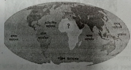
(A) Asia
(B) South America
(C) Africa
(D) Europe
Answer: C
40. Depth of Mariana Trench is- {Kamrup M}
(A) 11,012 meters
(B) 11,011 meters
(C) 11,022 meters
(D) 11,021 meters
Answer: C
41. Identify the dark shaded coastal region marked as A & B in the following picture. {Kamrup M}
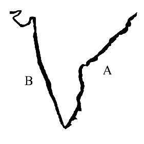
(A) Coromandel coast and Malabar coast
(B) Cape Comorin and Andaman and Nicobar
(C) Bay of Bengal and Lakshadweep.
(D) Malabar and bay of Bengal.
Answer: A
42. The major Islands under the pacific Ocean {Kamrup M}
(A) Canary, Folkland, Iceland
(B) Japan, Taiwan, New Zealand
(C) Maldives, Mauritius, Madagascar
(D) British isles, Sri Lanka, Sicily
Answer: B
43. Match the following countries with their appropriate populations. {Kamrup M}
Country
(1) Vatican City
(2) India
(3) China
(4) Bhutan
Population
(i) 131,40,97,616
(ii) 7,57,000
(iii) 800
(iv) 137,19,20,000
(A) 1-(iii), 2-(i), 3-(iv), 4-(ii)
(B) 1-(i), 2-(iv), 3-(ii), 4-(iii)
(C) 1-(iv), 2-(i), 3-(ii), 4-(iii)
(D) 1-(iii), 2-(iv), 3-(i), 4-(ii)
Answer: A
44. Match the following and choose the correct answer. {Kamrup R}
Continent
I) Asia–Africa
II) Asia–Europe
III) Europe–Africa
IV) North America–South America
Boundary
a) Mediterranean Sea
b) Red Sea
c) Panama Canal
d) Ural Mountain Range
(A) I-b, II-c, III-d, IV-a
(B) I-d, II-c, III-b, IV-a
(C) I-a, II-b, III-c, IV-d
(D) I-b, II-d, III-a, IV-c
Answer: D
45. Which statement best explains why the Pacific ocean is considered the largest? {Kamrup R}
(A) It contains the deepest trench.
(B) It covers the largest surface area of any ocean.
(C) It has the most Islands
(D) It connects the most continents
Answer: B
46. Identify the continent from the characterestics mentioned below. {Kamrup R}
i) This continent covers about 20% of the world’s total land area.
ii) The equator divides the continent into two parts.
iii) The world’s longest river Nile passes through this continent
(A) Asia
(B) Europe
(C) Africa
(D) Oceania
Answer: C
47. The capital of Canada is — {Kamrup R}
(A) Havana
(B) Ottawa
(C) Nasao
(D) Rasu
Answer: B
48. India has a land area about- {Kokrajhar}
(A) 32,87,263 Sq.Km.
(B) 34,87,263 Sq.Km.
(C) 32,67,263 Sq.Km.
(D) 42,87,263 Sq.Km.
Answer: A
49. Indonesia is in the – {Kokrajhar}
(A) Artic Ocean
(B) Indian Ocean
(C) Pacific Ocean
(D) Atlantic Ocean
Answer: c
50. The Tibetian Plateau is in- {Kokrajhar}
(A) The continent of Asia
(B) The continent of South America
(C) The continent of Africa
(D) The continent of Europe
Answer: A
51. In which ocean Falkland island is located?- {Kokrajhar}
(A) Atlantic ocean
(B) Arctic ocean
(C) Pacific ocean
(D) Indian ocean
Answer: A
52. What is the capital of Brazil? {Kokrajhar}
(A) Rio de Janeiro
(B) Sao Paulo
(C) Brasilia
(D) Lima
Answer: C
53. Which is the lowest populated continent in the world as per 2014 estimates? {Kokrajhar}
(A) Oceania
(B) South America
(C) Africa
(D) North America
Answer: A
54. Equator is located on which continent? {Kokrajhar}
(A) North America
(B) South America
(C) Africa
(D) Asia
Answer: B/C/D
55. Arrange the ranks of the highest peaks in the world in order- {Lakhimpur}
a) Mount Everest
b) Lhotse
c) Godwin Austen
d) Kanchenjunga
(i) First
(ii) Second
(iii) Third
(iv) Fourth
Options:
(A) a-i, b-ii, c-iii, d-iv
(B) a-iv, b-iii, c-ii, d-i
(C) a-i, b-iv, c-ii, d-iii
(D) a-iii, b-ii, c-i, d-iv
Answer: C
56. Name the Capital of Australia – {Lakhimpur}
(A) Beiging
(B) Tokyo
(C) Paris
(D) Canberra
Answer: D
57. The boundary between the continents of Europe and Africa is marked by- {Lakhimpur}
(A) Mediterranean Sea
(B) The Red Sea
(C) The Ural mountain range
(D) Panama Canal
Answer: A
58. Which continent is smaller than Asia and greater than North America? {Nagaon}
(A) South America
(B) Africa
(C) Europe
(D) Oceania
Answer: B
59. The continental land blocks on the north and south of the Tethys sea were – {Nagaon}
i) Pangea
ii) Angawra Land
iii) Gondowana Land
iv) Panthalassa
(A) (i) (ii)
(B) (ii) (iv)
(C) (ii) (iii)
(D) (iii) (v)
Answer: C
60. What is the name of the highest peak of the Andes located in South American continent? {Nagaon}
(A) Aconcagua
(B) Kanchanjangha
(C) Galan
(D) Cerro Bonete
Answer: A
61. In which continent is Ecuador located? {Nagaon}
(A) North America
(B) South America
(C) Africa
(D) Asia
Answer: B
62. What is the name of the largest lake located at the highest point of the world? {Nagaon}
(A) Titicacao
(B) Albert
(C) Edward
(D) Victoria
Answer: A
63. What percentage of world population lives in the Southern hemisphere? {Nalbari}
(A) 10%
(B) 70%
(C) 90%
(D) 50%
Answer: A
64. Match the following countries with their capitals and choose the correct option. {Nalbari}
Country
(a) Germany
(b) Japan
(c) Norway
(d) Newzeland
Capital
(i) Oslo
(ii) Berlin
(iii) Wellington
(iv) Tokyo
(A) a → ii, b → iv, c → i, d → iii
(B) a → i, b → iii, c → ii, d → iv
(C) a → iv, b → ii, c → i, d → ii
(D) a → iii, b → i, c → iv, d → ii
Answer: A
65. The correct descending order of the continents according to their land area is – {Nalbari}
(A) Asia → Africa → Europe → Oceania
(B) Africa → Asia → Europe → Oceania
(C) Asia → Europe → Africa → Oceania
(D) Oceania → Europe → Africa → Asia
Answer: A
66. Consider the following statements (I) and (II) about the Pacific Ocean and choose the correct option – {Nalbari}
Statement-I : Among the oceanic trenches, Mariana Trench in the pacific ocean floor in the deepest
Statement-II: The average depth of the pacific ocean is about 4000 meter.
(A) I is true, II is false
(B) I is false, II is true
(C) Both are true
(D) Both are false
Answer: A
67. Which of the following statements correctly describe the continental Drift theory? {Nalbari}
(i) The Earth’s lithosphere was together as a single landmass which was surrounded by hydrosphere.
(ii) The hydrosphere surrounding the lithosphere is known as Panthalasa.
(iii) Tethys sea divided the pangea into two parts in east-west direction.
(iv) Greenland and North America were formed after division of the Gondowanaland.
(A) i, ii
(B) i, iii
(C) ii, iv
(D) i, iii, iv
Answer: A
68. On the basis of the information given in (a) and (r), choose the right option – {Nalbari}
Assertion (a) : The large portion of the hydrosphere is confined to the Southern Hemisphere.
Reason (r) : The Southern Hemisphere has relatively more oceanic area and less land as compared to the Northern Hemisphere.
(A) (a) is correct, (r) is incorrect
(B) (a) is incorrect, (r) is correct
(C) Both (a) and (r) are correct and (r) is the correct explanation of (a)
(D) Both (a) and (r) are correct, but (r) is not the correct explanation of (a)
Answer: C
69. Match the following: {Sibsagar}
(a) Africa
(b) Europe
(c) Asia
(d) North America
(i) Baikal
(ii) Superior
(iii) Victoriya
(iv) Unega
(A) a – i, b – ii, c – iii, d – iv
(B) a – ii, b – i, c – iv, d – iii
(C) a – iii, b – iv, c – i, d – ii
(D) a – iv, b – iii, c – ii, d – i
Answer: C
70. Arranged in the correct order according to the depth of the ocean. {Sibsagar}
(A) Atlantic – Pecific – Indian Ocean – Arctic Ocean
(B) Pecific – Atlantic – Indian Ocean – Arctic Ocean
(C) Indian Ocean – Arctic Ocean – Pecific – Atlantic
(D) Arctic Ocean – Pecific – Atlantic – Indian Ocean
Answer: B
71. Find the correct answer: {Sibsagar}
A: Asia is the most populous continent in the world.
B: Europe has a higher population growth rate than Africa.
(A) A is true, B is false
(B) A is false, B is true
(C) A and B both are true
(D) A and B both are false
Answer: A
72. The following table Study the data table below and answer the question : {Sibsagar}
|
Coutinent |
Area million sq. km |
Population in billions |
|
Asia |
44.5 |
4.7 |
|
Africa |
30.3 |
1.4 |
|
Europe |
10.2 |
0.7 |
|
South America |
17.8 |
0.4 |
Which continent has the highest population dansity.
(A) Africa
(B) Asia
(C) Europe
(D) South America
Answer: B
73. Which of the following countries belong to the South America continent. {Sibsagar}
(a) Costarica
(b) Dominica
(c) Colombia
(d) Vanezualla
(A) a and b
(B) c and d
(C) a and d
(D) d, b and c
Answer: B
74. Which sea separates Asia and Africa ? {Sonitpur}
(A) Mediterranean sea
(B) Red sea
(C) Caspian sea
(D) Arabian sea
Answer: B
75. What is the depth of the deepest trench of pacific ocean known as mariana ? {Sonitpur}
(A) 11,000 meter
(B) 11,002 meter
(C) 11,022 meter
(D) 11,032 meter
Answer: C
76. The Mediterranean Sea lies between which two continents? {Sribhumi}
(A) Asia and America
(B) Europe and Africa
(C) Africa and Australia
(D) Asia and Europe
Answer: B
77. Which continent lies to the East of Europe? {Sribhumi}
(A) Asia
(B) North America
(C) Africa
(D) Antarctica
Answer: A
78. The world’s second largest Ocean – {Sribhumi}
(A) Pacific Ocean
(B) Indian Ocean
(C) Arctic Ocean
(D) Atlantic Ocean
Answer: D
79. The capital of Russia is – {Sribhumi}
(A) Muscat
(B) Moscow
(C) Beirut
(D) Bangkok
Answer: B
80. Which of the following pairs are correctly matched? {Salmara}
(A) Asia: 53
(B) Africa: 51
(C) North America: 23
(D) South America: 14
Answer: C
81. Which of the following oceans is in the correct order from largest to smallest? {Salmara}
(A) Atlantic Ocean → Indian Ocean → Southern Ocean → Northern Ocean
(B) Northern Ocean → Southern Ocean → Indian Ocean → Atlantic Ocean
(C) Atlantic Ocean → Southern Ocean → Indian Ocean → Northern Ocean
(D) Indian Ocean → Atlantic Ocean → Southern Ocean → Northern Ocean
Answer: A
82. Which Sea has separated the Continents of Asia and Africa? {Salmara}
(A) Mediterranean sea
(B) Red sea
(C) Caspian sea
(D) Ural mountain range
Answer: B
83. Match the following and choose the correct answer. {Salmara}
Country
i. Indonesia
ii. Afghanistan
iii. China
iv. Bhutan
Capital
a. Kabul
b. Thimphu
c. Jakarta
d. Beijing
(A) i-c, ii-a, iii-b, iv-d
(B) i-c, ii-b, iii-d, iv-a
(C) i-c, ii-d, iii-a, iv-b
(D) i-c, ii-a, iii-d, iv-b
Answer: D
84. Identify the continent from the characteristics mention below: {Salmara}
i. The land area of this continent is about 8 million km²
ii. The continent is the sixth largest country in the world.
iii. As per data 2014, the continent has a total population of about 38 million.
(A) Europe
(B) South America
(C) Oceania
(D) North America
Answer: C
85. Identify the countries in Section (A) with their respective capital in Section (B): {Udalguri}
Section A:
(i) Bangladesh
(ii) Bhutan
(iii) China
(iv) Sri Lanka
Section B:
(a) Beijing
(b) Dhaka
(c) Colombo
(d) Thimphu
Options:
(A) i-b, ii-d, iii-a, iv-c
(B) i-c, ii-a, iii-a, iv-c
(C) i-d, ii-c, iii-b, iv-a
(D) i-d, ii-a, iii-c, iv-b
Answer: A
86. Among the Ocean Trenches, Mariana or Challenger is the deepest trench on earth. Which ocean does this trench belong to? {Udalguri}
(A) Atlantic Ocean
(B) Pacific Ocean
(C) Indian Ocean
(D) Southern Ocean
Answer: B
87. “Kalahari Desert” belongs to which continent? {Udalguri}
(A) Asia
(B) Africa
(C) Europe
(D) Oceania
Answer: B
88. Consider the Statement (i) and (ii) regarding the distribution of continents and oceans and choose the correct answer from the options shown below: {Udalguri}
(i) During the Permian period of the Paleozoic era, the Earth’s lithosphere was united and surrounded by the hydrosphere.
(ii) According to the Mesozoic era – Oceans were formed approximately 250 million years ago due to crystal ruling and continental drift.
(A) Both (i) and (ii) are true
(B) (i) is true, (ii) is false
(C) (i) is false, (ii) is true
(D) Both (i) and (ii) are false
Answer: A
Probable Multiple Choice Questions with Answers for HSLC 2027
1. What is the total surface area of the Earth?
(A) 310 million square kilometers
(B) 410 million square kilometers
(C) 510 million square kilometers
(D) 610 million square kilometers
Answer: C
2. According to Alfred Wegener’s Continental Drift Theory, what was the vast supercontinent called where all the present continents were joined together in ancient times?
(A) Laurasia
(B) Gondwanaland
(C) Panthalassa
(D) Pangaea
Answer: D
3. The deepest oceanic trench on Earth, the ‘Mariana Trench’, is located in which ocean?
(A) Pacific Ocean
(B) Atlantic Ocean
(C) Indian Ocean
(D) Arctic Ocean
Answer: A
4. What naturally separates the continents of Asia and Europe?
(A) The Himalayan Mountains and the Ganga River
(B) The Alps and the Rhine River
(C) The Ural Mountains and the Ural River
(D) The Andes Mountains and the Amazon River
Answer: C
5. Which is the second largest continent on Earth in terms of land area?
(A) Asia
(B) North America
(C) Europe
(D) Africa
Answer: D
6. In which continent is the longest mountain range on Earth, the ‘Andes’, located?
(A) Asia
(B) North America
(C) South America
(D) Europe
Answer: C
7. What is the name of the ocean that is shaped like the English letter ‘S’?
(A) Pacific Ocean
(B) Atlantic Ocean
(C) Indian Ocean
(D) Southern Ocean
Answer: B
8. The world’s largest desert, the ‘Sahara’, is located in which continent?
(A) Africa
(B) Asia
(C) Australia
(D) South America
Answer: A
9. Which canal connects the continents of North America and South America?
(A) Suez Canal
(B) Panama Canal
(C) Kiel Canal
(D) Grand Canal
Answer: B
10. What is the name of the highest mountain peak in the continent of Africa?
(A) Mount Everest
(B) Mount McKinley
(C) Mount Kilimanjaro
(D) Mount Elbrus
Answer: C
11. In which continent is the world’s largest river island, ‘Majuli’, located?
(A) Africa
(B) Asia
(C) Europe
(D) Oceania
Answer: B
12. Which of the following seas is NOT located to the east of the continent of Asia?
(A) Bering Sea
(B) Arabian Sea
(C) Sea of Japan
(D) Sea of Okhotsk
Answer: B
13. In which continent is the extensive grassland region named ‘Downs’ found?
(A) North America
(B) South America
(C) Oceania (Australia)
(D) Europe
Answer: C
14. Approximately what percentage of the Earth’s total water volume is contained in the Pacific Ocean?
(A) 25.5%
(B) 35.5%
(C) 45.5%
(D) 55.5%
Answer: C
15. Which of the following is a major river in the continent of Europe?
(A) Hwang Ho
(B) Mississippi
(C) Volga
(D) Amazon
Answer: C
16. In which continent is ‘Death Valley’ located?
(A) North America
(B) Africa
(C) Asia
(D) Antarctica
Answer: A
17. What is the name of the smallest ocean on Earth?
(A) Indian Ocean
(B) Arctic Ocean
(C) Southern Ocean
(D) Atlantic Ocean
Answer: B
18. New Zealand belongs to which continent?
(A) Asia
(B) Africa
(C) Oceania
(D) Europe
Answer: C
19. Which of the following countries extends across both Asia and Europe?
(A) India
(B) Russia
(C) China
(D) Germany
Answer: B
20. What is the name of the largest country in South America?
(A) Argentina
(B) Colombia
(C) Chile
(D) Brazil
Answer: D
21. Where is the ‘Rub’ al Khali’ desert located?
(A) Arabian Peninsula
(B) Australia
(C) Africa
(D) China
Answer: A
22. In which direction of the Indian Ocean is the country of Sri Lanka located?
(A) Northern part
(B) Southern part
(C) Eastern part
(D) Western part
Answer: A
23. The Earth’s second-highest mountain peak ‘K2’ or Godwin Austen is located in which mountain range?
(A) Himalayas
(B) Karakoram
(C) Alps
(D) Andes
Answer: B
24. What does the shape of the continent of Antarctica look like when considered without its ice cover?
(A) Circular
(B) Triangular
(C) Like a duck’s foot or a butterfly
(D) Quadrilateral
Answer: C
25. What is the name of the longest river in the continent of Asia?
(A) Ganga
(B) Hwang Ho
(C) Yangtze
(D) Mekong
Answer: C
26. Match Column A with Column B and select the correct option:
Column A (Mountain Range)
(a) Alps
(b) Rocky
(c) Himalayas
Column B (Continent)
(i) North America
(ii) Asia
(iii) Europe
(A) (a)-ii, (b)-iii, (c)-i
(B) (a)-i, (b)-ii, (c)-iii
(C) (a)-iii, (b)-i, (c)-ii
(D) (a)-iii, (b)-ii, (c)-i
Answer: C
27. Consider the following statements and choose the correct answer:
(i) Approximately 97% of the total water on Earth is found in the oceans.
(ii) Ocean water is fit for human drinking.
(iii) Most of the Earth’s landmass is located in the Southern Hemisphere.
(A) Only (i) is correct
(B) Only (ii) and (iii) are correct
(C) Only (i) and (iii) are correct
(D) All are correct
Answer: A
28. Match Column A with Column B:
Column A (River)
(a) Amazon
(b) Nile
(c) Murray-Darling
Column B (Continent)
(i) Africa
(ii) Oceania
(iii) South America
(A) (a)-ii, (b)-i, (c)-iii
(B) (a)-iii, (b)-i, (c)-ii
(C) (a)-i, (b)-ii, (c)-iii
(D) (a)-iii, (b)-ii, (c)-i
Answer: B
29. Which of the following statements about the Northern Hemisphere are correct?
(i) About 67% of the Earth’s total landmass is located in this hemisphere.
(ii) About 90% of the world’s total population lives in this hemisphere.
(iii) This hemisphere is called the ‘Water Hemisphere’.
(A) Only (i) and (ii)
(B) Only (ii) and (iii)
(C) Only (i) and (iii)
(D) All (i), (ii), and (iii) are correct
Answer: A
30. According to the Continental Drift Theory, what was the northern part of ‘Pangaea’ called, which comprised present-day North America, Europe, and Asia?
(A) Gondwanaland
(B) Laurasia (Angaraland)
(C) Tethys
(D) Eurasia
Answer: B
31. Match Column A with Column B:
Column A (Desert)
(a) Kalahari
(b) Gobi
(c) Atacama
Column B (Continent)
(i) Asia
(ii) South America
(iii) Africa
(A) (a)-iii, (b)-ii, (c)-i
(B) (a)-i, (b)-iii, (c)-ii
(C) (a)-iii, (b)-i, (c)-ii
(D) (a)-ii, (b)-i, (c)-iii
Answer: C
32. Which of the following Country – Capital pairs is incorrect?
(A) Japan – Tokyo
(B) China – Beijing
(C) Iran – Baghdad
(D) Sri Lanka – Colombo
Answer: C
33. Which of the following statements regarding the physiographic features of the Atlantic Ocean is incorrect?
(A) The ‘Mid-Atlantic Ridge’ is situated from north to south in the middle of this ocean.
(B) Its depth is greater than that of the Pacific Ocean.
(C) The shape of this ocean is similar to the English letter ‘S’.
(D) The Puerto Rico Trench is the deepest trench in this ocean.
Answer: B
34. Arrange the Earth’s oceans in descending order of their total area (largest to smallest):
(i) Indian Ocean
(ii) Pacific Ocean
(iii) Atlantic Ocean
(iv) Arctic Ocean
(A) (ii) → (iii) → (i) → (iv)
(B) (ii) → (i) → (iii) → (iv)
(C) (iii) → (ii) → (i) → (iv)
(D) (ii) → (iii) → (iv) → (i)
Answer: A
35. Which two seas separate the continent of Africa from Europe and Asia?
(A) Arabian Sea and Red Sea
(B) Mediterranean Sea and Red Sea
(C) Caspian Sea and Black Sea
(D) Mediterranean Sea and Caspian Sea
Answer: B
36. Which of the following lakes is NOT a part of the ‘Great Lakes’ of North America?
(A) Superior
(B) Michigan
(C) Baikal
(D) Huron
Answer: C
37. Match Column A with Column B:
Column A (Country)
(a) Egypt
(b) Brazil
(c) Canada
Column B (Capital)
(i) Ottawa
(ii) Cairo
(iii) Brasilia
(A) (a)-ii, (b)-iii, (c)-i
(B) (a)-iii, (b)-ii, (c)-i
(C) (a)-i, (b)-iii, (c)-ii
(D) (a)-ii, (b)-i, (c)-iii
Answer: A
38. Where did Alfred Wegener mention the ‘Tethys Sea’ was located?
(A) Between Laurasia and Gondwanaland
(B) Between North America and South America
(C) All around Pangaea
(D) Between Africa and Australia
Answer: A
39. Which of the following countries is NOT a part of the continent of Asia?
(A) Indonesia
(B) Malaysia
(C) Nigeria
(D) Maldives
Answer: C
40. What are the names of the two oceans located at the Earth’s polar regions?
(A) Pacific and Atlantic Oceans
(B) Arctic Ocean and Southern Ocean
(C) Indian and Arctic Oceans
(D) Pacific and Southern Oceans
Answer: B
41. Assertion (A): The Southern Hemisphere is called the ‘Water Hemisphere’.
Reason (R): Approximately 81 percent of the total area of the Southern Hemisphere is covered by water, and the proportion of landmass is very low.
(A) Both (A) and (R) are true, and (R) is the correct explanation of (A).
(B) Both (A) and (R) are true, but (R) is not the correct explanation of (A).
(C) (A) is true, but (R) is false.
(D) (A) is false, but (R) is true.
Answer: A
42. Assertion (A): There is no permanent human settlement in the continent of Antarctica.
Reason (R): Being located at the Earth’s South Pole, this continent remains covered with thick ice throughout the year and its climate is extremely cold.
(A) Both (A) and (R) are true, and (R) is the correct explanation of (A).
(B) Both (A) and (R) are true, but (R) is not the correct explanation of (A).
(C) (A) is true, but (R) is false.
(D) (A) is false, but (R) is true.
Answer: A
43. Assertion (A): The Pacific Ocean is known as the most active earthquake and volcanic zone on Earth.
Reason (R): There is a continuous chain of active volcanoes all around this ocean, which is called the ‘Pacific Ring of Fire’.
(A) Both (A) and (R) are true, and (R) is the correct explanation of (A).
(B) Both (A) and (R) are true, but (R) is not the correct explanation of (A).
(C) (A) is true, but (R) is false.
(D) (A) is false, but (R) is true.
Answer: A
44. Assertion (A): Alfred Wegener proved in his ‘Continental Drift Theory’ that continents are always static and never move.
Reason (R): All the landmasses of the Earth’s surface were once a single giant supercontinent called ‘Pangaea’, which later broke apart to form the present-day continents.
(A) Both (A) and (R) are true, and (R) is the correct explanation of (A).
(B) Both (A) and (R) are true, but (R) is not the correct explanation of (A).
(C) (A) is true, but (R) is false.
(D) (A) is false, but (R) is true.
Answer: D
45. Assertion (A): The population density of the European continent is comparatively higher than that of other continents.
Reason (R): Europe has a favorable climate, advanced transportation systems, and it is industrially one of the most advanced continents in the world.
(A) Both (A) and (R) are true, and (R) is the correct explanation of (A).
(B) Both (A) and (R) are true, but (R) is not the correct explanation of (A).
(C) (A) is true, but (R) is false.
(D) (A) is false, but (R) is true.
Answer: A
46. Assertion (A): The coastline of the Atlantic Ocean is highly indented and irregular.
Reason (R): Because of this highly indented coastline, many advanced and natural ports have been developed along the shores of the Atlantic Ocean.
(A) Both (A) and (R) are true, and (R) is the correct explanation of (A).
(B) Both (A) and (R) are true, but (R) is not the correct explanation of (A).
(C) (A) is true, but (R) is false.
(D) (A) is false, but (R) is true.
Answer: B
47. Assertion (A): The continent of Oceania is called the ‘Island Continent’.
Reason (R): This continent consists primarily of Australia, New Zealand, Tasmania, and numerous large and small islands scattered across the Pacific Ocean.
(A) Both (A) and (R) are true, and (R) is the correct explanation of (A).
(B) Both (A) and (R) are true, but (R) is not the correct explanation of (A).
(C) (A) is true, but (R) is false.
(D) (A) is false, but (R) is true.
Answer: A
48. Assertion (A): The continent of Africa is also referred to as the ‘Dark Continent’.
Reason (R): Only dark-skinned people live everywhere in Africa and the sun’s rays never reach there.
(A) Both (A) and (R) are true, and (R) is the correct explanation of (A).
(B) Both (A) and (R) are true, but (R) is not the correct explanation of (A).
(C) (A) is true, but (R) is false.
(D) (A) is false, but (R) is true.
Answer: C
49. Assertion (A): The northern part of the Indian Ocean is not open like other oceans.
Reason (R): The northern direction of the Indian Ocean is landlocked by the massive landmass of the Asian continent.
(A) Both (A) and (R) are true, and (R) is the correct explanation of (A).
(B) Both (A) and (R) are true, but (R) is not the correct explanation of (A).
(C) (A) is true, but (R) is false.
(D) (A) is false, but (R) is true.
Answer: A
50. Assertion (A): The region that receives the highest rainfall in the world is located in the continent of Asia.
Reason (R): Mawsynram, located in the state of Meghalaya in India, receives the highest average annual rainfall in the world.
(A) Both (A) and (R) are true, and (R) is the correct explanation of (A).
(B) Both (A) and (R) are true, but (R) is not the correct explanation of (A).
(C) (A) is true, but (R) is false.
(D) (A) is false, but (R) is true.
Answer: A
HSLC PYQs (2016–2026): Important 2/3 Marks Short Questions
HSLC PYQs (2016–2026): Important 2‑ and 3‑Mark Short Questions
1. Write the name of two countries of Europe located in the Mediterranean region. {2020}
2. What is the name of the major mountain range of North America? In which part of the continent is it located? {2019}
3. Name the continental land block on the north and south of the Tethys Sea. {2022}
4. Which is the world’s largest and where is it located? {2018}
5. Write the names of two countries of Europe located in the Mediterranean Region. {2018}
6. Which is the largest Ocean in the world? Mention the area of the Ocean. {2017}
7. Discuss the factors responsible for the variations of climates in Asia. {2017}
8. Write the names of the countries and their capitals of the continent of Europe. {2017}
9. How many countries are there in the world? In terms of land area, name the largest and smallest country in the world. {2017}
19. Name two mountain ranges extending towards west from Pamir Knot.{2016}
HSLC PYQs (2016–2026): Important 4/5 Marks Long Questions
HSLC PYQs (2016–2026): Important 2‑ and 3‑Mark Short Questions
1. Discuss the geographical features of the Indian Ocean. {2026}
2. Based on the features given in the following table, compare the Pacific Ocean and the Atlantic Ocean. Draw the table and write your responses in it: {2025}
|
Sl No. |
Features |
Pacific Ocean |
Atlantic Ocean |
|
(i) |
Location |
||
|
(ii) |
Land Area |
||
|
(iii) |
Average Depth |
||
|
(iv) |
Major islands (any two) |
||
|
(v) |
Major Seas in the Ocean (any two) |
3. Describe how the condition of the earth was in the early days according to the Continental Drift Theory. {2024}
4. Discuss the physical characteristics of the continent of Asia. {2024}
5. Briefly describe the Earth’s lithosphere and hydrosphere. {2023}
6. Name the smallest ocean in the world. {2023}
7. Write briefly about the distribution of oceans continents in the world.{2022}
8. Briefly describe the Continental Drift Theory. {2022}
9. Discuss the physical characteristics of Asia. {2020}
10. Describe the distribution and characteristics of the oceAnswer: {2020}
11. Briefly discuss the physical characteristics of the continent of North America. {2019}
12. Write in short about the landforms present on the Earth’s land surface. {2019}
13. Describe briefly the continental drift theory. {2018}
14. Discuss the factors responsible for the variations of climates in Asia. {2016}

District Pre Board (2025–26): Important 2 Marks Short Questions
1. Is the water surface and the bottom of the oceans similar? {Cachar}
2. Match the names of the continents in column (A) with the natural boundary elements in column (B). {Darrang}
Column A (Name of continents):
(a) North America – South America
(b) Europe and Africa
(c) Asia and Africa
(d) Europe and Asia
Column B:
(i) Panama Canal
(ii) Red Sea
(iii) Ural Mountains
(iv) Mediterranean Sea
3. Write two differences between the continent of Oceania and Antarctica. {Kamrup R}
4. Write the name of two rivers in Asia continent which flow in the north. {Lakhimpur}
5. Why is Antractica the only continent without permanent human settlement? {Nalbari}
District Pre Board (2025–26): Important 3 Marks Long Questions
6. Asia is a continent of varied physical features. Explain. {Cachar}
7. Rank the following continents from the largest to the smallest by area: Africa, Asia, Europe, Antarctica. Identify the continent that lies completely in the southern hemisphere and why it has no permanent human settlement. {Hailakandi}
8. Based on the features given in the following table, compare the Africa continent and European continent. Draw the table and write any three responses in it: {Hailakandi}
|
Sl. No. |
Features |
Pacific Ocean |
Atlantic Ocean. |
|
i) |
Location |
||
|
ii) |
Land area |
||
|
iii) |
Average depth |
||
|
iv) |
Major islands |
||
|
v) |
Major seas in the ocean |
9. Why are the man’s way of living are different in different places on the earth? {Kokrajhar}
10. How many countries are there in the world today? Write two largest and smallest countries in the world by land area. {Lakhimpur}
11. Asia is the largest and most populous continent in terms of size with a population of about 4.3 billion. It has geographical diversity like mountains, plateaus, river valleys, islands, deserts, coastal plains etc. but all regions of Asia are not equally developed. Explain the above based on your own point of view. {Morigaon}
12. Briefly describe how Pangea helped in forming present continents by its divisions? {Nalbari}
13. Write in brief about the Earth’s lithosphere and hydrosphere? {Sribhumi}
District Pre Board (2025–26): Important 4 Marks Long Questions
14. Discuss the three physical characteristics of the continent of Asia. Why doesn’t human settlement on the continent of Antarctica? {Bongaigaon}
15. Write short note on – Continental Drift Theory {Cachar}
16. “Asia is the largest continent in the world” – Give two evidences with facts to support the above statement by comparing it with other continents. {Darrang}
17. Write the differences between: {Jorhat}
a) Continental Shelf and Continental Slope.
b) The Continent of Oceania and the Continent of Antarctica.
18. Compare the difference between the continent of Europe and Africa based on the data given below: {Kokrajhar}
|
SI. No. |
Name of Continent |
Land area (million km.) |
Proportion to total land area to the Lithosphere in % |
|
1. |
Asia |
44.6 |
29.9 |
|
2. |
Europe |
10.9 |
7.3 |
|
3. |
Africa |
30.1 |
20.2 |
|
4. |
North America |
24.3 |
16.3 |
|
5. |
South America |
17 .8 |
11.9 |
\
District Pre Board (2025–26): Important 5 Marks Long Questions
19. How was the earth in the early days according to the ‘Continental Drift Theory’? {Bajali}
20. Briefly descibe the physical characteristics of Europe. {Bajali}
21. Describe the natural characteristics of Asia continent. {Baksa}
22. Describe breifly about lithosphere and hydrosphere of the earth. {Baksa}
23. Based on the features given in the following table compare the Asia Continent and Ocenia Continent. Draw the table and write your response in it. {Barpeta}
|
Features |
Asia continent |
Oceania Continent |
|
Location |
||
|
Land Area |
||
|
Population |
||
|
Desert |
||
|
River |
24. Complete the following table. {Biswanath}
|
Country Name |
Capital |
|
1. China |
…………. |
|
Thimphu |
|
|
3. India |
…………. |
|
…………. |
Tokyo |
|
…………. |
Islamabad |
25. Complete the following table about Indian Ocean. {Biswanath}
Indian Ocean
Area
The average depth
Oceanic trenches
Important sea
Oceanic island
26. Briefly discuss the physiographic characteristics of the continent of Asia. {Dhubri}
27. Briefly describe why the physiographic structure of the North American continent is said to be diverse. {Majuli}
28. Describe what the state of the earth was originally like according to the Continental Drift Theory. {Majuli}
29. The list includes some information from Asia and Europe, Answer the following questions from the list. {Sibsagar}
|
Mountain ranges |
The Urals , Aravalli, The Alps, The Caucasus |
|
The Plateau |
Siberian, Mongolia |
|
River |
Amur,Chikiang, Ron,Oder |
|
Lake |
Sambar, Pulicat, The Venarn, Onega |
(i) Name a mountain range of Europe.
(ii) The Mongolian Plateau is located on which continent?
(iii) Name a lake in Asia.
(iv) Name two rivers of Europe.
30. Discuss, what the earth was like in the beginning as per continental drift theory? {Sonitpur}
31. Discuss briefly the physical features of Asian continent. {Sonitpur}
32. How was the earth in the early days according to the Continental Drift theory? {Salmara}
33. Briefly discuss the physical characteristics of Asia. {Salmara}
34. Provide a comparative explanation of the Atlantic and Indian Oceans covering land area, boundaries, oceanic trenches (two), seas (two) and islands (two). {Tamulpur}
Some Important Most Probable 2 Marks Questions for HSLC 2027
1. According to Alfred Wegener, what was ‘Panthalassa’?
2. Name any two major rivers of the North American continent.
3. Write the names of the two natural boundaries that separate the continent of Europe from Asia.
4. What is the percentage distribution of landmass and water bodies on Earth?
5. Briefly mention the geographical boundaries of the Indian Ocean.
6. Name two significant deserts located in the African continent.
7. Write the names of the present-day continents that were originally part of the ‘Laurasia’ landmass.
8. Name two major lakes found in the South American continent.
9. Name the two Indian research stations established in the continent of Antarctica.
10. Name the second and the third largest oceans in the world.
Some Important Most Probable 3 Mark Questions for HSLC 2027
11. Briefly explain the core concept of Alfred Wegener’s ‘Continental Drift Theory’.
12. Mention three major characteristics of the Atlantic Ocean.
13. Write a short note on the lakes of the North American continent (especially focusing on the ‘Great Lakes’).
14. Why is the Northern Hemisphere called the ‘Land Hemisphere’? Give reasons.
15. Give a brief overview of the physiographic characteristics of the continent of Europe.
16. Name any three countries located in the continent of Asia along with their respective capitals.
17. Briefly write about the major river systems of the South American continent.
18. Give a brief description of the deep oceanic trenches found in the Pacific Ocean.
19. Mention the geographical location of the continent of Oceania and name its major regional divisions.
20. Name the present-day continents that were formed following the fragmentation of the Gondwanaland supercontinent and briefly explain the process.
Some Important Most Probable 4 Mark Questions for HSLC 2027
21. Discuss in detail the physiographic divisions and geographical characteristics of the Asian continent.
22. Describe the boundaries, total surface area, and major submarine physiographic features of the Pacific Ocean.
23. Why is the physiography of the North American continent considered highly diverse? Describe its major mountain ranges and plains.
24. Write extensively about the geographical location, major rivers, and vast deserts of the African continent.
25. According to the Continental Drift Theory, provide a chronological account of how the present-day continents and oceans evolved from their primitive states.
26. What does the bottom topography of the Earth’s oceans look like? Discuss the mid-oceanic ridges, ocean basins, and deep-sea trenches.
27. Present a descriptive picture of the physiography of South America. Pay special attention to the Andes mountain range and the Amazon basin in your answer.
28. Discuss the river systems and plateau regions of Europe. What is the significance of these rivers in the economic development of Europe?
29. Prepare a comprehensive essay on the geographical environment, harsh climate, and scientific significance of the continent of Antarctica.
30. Discuss the geographical location of the Indian Ocean and describe its submarine physiographic features (such as oceanic ridges and islands).