Class 9 Geography Chapter 1 – Weather and Climate Complete Solutions | Assam Board (ASSEB) | Latest Syllabus | English Medium
Class 9 Geography Chapter 1 – Weather and Climate Complete Solutions (Assam Board – ASSEB – English Medium)
This chapter introduces the fundamental concepts of weather and climate, explaining how atmospheric conditions vary and affect human life. Students will learn about the elements of weather, different climatic zones, and various factors that influence climate. The chapter includes well-explained solutions and practice exercises to make understanding easier.
✅ What you will learn:
- Basic concepts of weather and climate
- Elements of weather – temperature, pressure, humidity, wind, etc.
- Factors influencing climate
- Major climatic zones across the globe
- Difference between weather and climate
🎯 Why choose Ospin Academy?
- Complete solutions for all questions from the latest Assam Board (ASSEB) syllabus
- English medium explanations with easy-to-understand language
- Designed to help students prepare effectively for exams
- Practice questions and answers for better concept clarity
- Dedicated resources aligned with the latest syllabus for Class 9 Geography

Class 9 Geography Elective English Medium | Latest Syllabus Chapter-wise Solutions PDF
Limited Time Offer!
(For Class 9 Geography Elective, English Medium)
Prepare thoroughly for Class 9 Geography Elective with this chapter-wise solutions PDF.
Includes complete, clear, and exam-focused textual solutions as per the latest syllabus.
Ideal for self-study, homework help, and last-minute revision.
Chapter-1
Weather and Climate
1. What do you mean ‘weather’ and ‘climate’? Distinguish between weather and climate.
Answer: Weather refers to the state of the atmosphere at a particular location over a brief duration or short span of time. Conversely, climate is defined as the mean or typical atmospheric conditions experienced in a region, calculated by averaging meteorological data over an extended period, typically a minimum of 30 years.
The differences between weather and climate are:
SI No. | Basis of difference | Weather | Climate |
|---|---|---|---|
(i) | Period | Considered over a short period of time such as a day, a week, etc. | Considered over a long period of time (at least 30 years). |
(ii) | Area | Indicates the atmospheric conditions over a small area. | Refers to the atmospheric conditions over a large area. |
2. Mention the elements of weather and climate.
Answer: The main elements of weather and climate are:
(i) Temperature
(ii) Pressure of air
(iii) Humidity
(iv) Wind
(v) Precipitation
3. State the elements of weather and climate.
Answer: The chief components that constitute weather and climate are temperature, atmospheric pressure, humidity, wind, and precipitation.
(a) Temperature: The influence of temperature on weather and climate includes:
(i) The Earth absorbs energy from the Sun’s light and heat. Upon reaching the Earth’s surface, the incoming solar radiation is reflected back, and this latent heat warms the lowest atmospheric layer—the troposphere. As the air in this layer warms, it rises, causing cooler air from adjacent regions to flow in. This process results in the formation of centres of low and high atmospheric pressure.
(ii) Temperature changes vertically within the atmosphere. As altitude increases, the temperature decreases at a steady lapse rate of 6.5C° per kilometre within the troposphere.
(iii) Horizontal temperature variation is also observed, primarily due to differences in the angle of insolation (sun’s rays). Temperature generally diminishes when moving away from the equator and proceeding toward the poles.
(b) Pressure of air or atmospheric pressure: The force exerted by air per unit area influences weather and climate in the following ways:
(i) The air near the Earth’s surface is significantly compressed, leading to an increase in its density. An increase in density results in a corresponding rise in atmospheric pressure. Conversely, as we ascend, the density of air diminishes, causing the atmospheric pressure to drop.
(ii) Atmospheric pressure also undergoes horizontal variations. Air density tends to be lower around the equator but higher in the polar regions. Consequently, atmospheric pressure is notably high at the poles and low near the equator.
(c) Humidity:
Humidity, which is the amount of water vapour present in the air, significantly affects a location’s weather and climate. Temperature is the primary factor determining the capacity of air to retain water, and thus, air holds different quantities of water vapour depending on the place and time. Warm air is capable of holding a greater volume of water vapour, whereas cold air can hold a comparatively smaller amount.
(d) Wind:
Wind is the horizontal movement of air from an area of high pressure towards an area of low pressure. Winds are generated by the spatial and temporal differences in pressure, which themselves are created by variations in temperature across different locations. Wind has the ability to either moderate or intensify the temperature of a region, thereby affecting its overall climatic conditions.
(e) Precipitation:
When the water vapour present in the air is cooled, it condenses and subsequently returns to the Earth’s surface in various forms; this process is termed precipitation. The diverse forms of precipitation include dew, fog, mist, sleet, snowfall, rainfall, and drizzle, among others. Of these, both rainfall and snowfall exert a considerable influence on the weather and climatic state of a place.
4. Explain the relationships among temperature, pressure and humidity.
Answer: A close interdependence exists among temperature, pressure, and humidity.
(i) The relationship between temperature and pressure is inverse: as temperature rises, the atmospheric pressure decreases, and conversely, a decrease in temperature leads to an increase in pressure.
(ii) A distinct connection exists between humidity and temperature. Warm air has a higher capacity to hold water vapour, while cold air holds less. When the temperature is high, the air is less dense and lighter, allowing it to accommodate more water vapour. In essence, high temperature generally correlates with high humidity, and the reverse is also true.
(iii) The relationship between humidity and pressure is also inverse: air with high humidity typically registers a low pressure reading. Stated differently, an increase in humidity is associated with a decrease in air pressure, and vice versa.
5. How are the variations in atmospheric pressure caused?
Answer: Atmospheric pressure is the measure of the force exerted by the air column on a unit area. Its magnitude changes based on the following factors:
(i) Air temperature: The distribution of temperature is not uniform across the Earth’s surface due to the varying inclination (angle) of the sun’s rays. These temperature discrepancies cause some regions to be hot, others cold, and still others to have moderate temperatures. High temperatures are associated with low pressure, while low temperatures are associated with high pressure. Consequently, the equatorial region, which receives high temperatures, experiences low pressure, while the polar regions, which are very cold, experience high pressure.
(ii) Surface elevation or height: Atmospheric pressure systematically decreases as the surface elevation or altitude increases. The pressure diminishes at an approximate rate of 34 millibars (\text{mb}) for every 900 feet of ascent within the troposphere.
6. Why does wind blow?
Answer: The existence of varying temperature conditions causes different places to have different atmospheric pressures. In areas characterised by elevated temperatures, the air becomes heated, rises, and in doing so, generates a low-pressure zone. This low-pressure area then draws in air from the surrounding regions that are experiencing high pressure. This influx and movement of air is the fundamental reason for the blowing of wind.
7. What is precipitation? Name the different types of precipitation.
Answer: Precipitation is the process where the water vapour contained in the atmosphere undergoes condensation, causing the resulting water droplets or ice crystals to increase in size. These then fall towards the Earth’s surface in various forms due to the force of gravity.
The various forms of precipitation include:
(i) Dew
(ii) Fog
(iii) Mist
(iv) Sleet
(v) Snowfall
(vi) Rainfall
(vii) Drizzle
8. Mention the factors affecting weather and climate.
Answer: The key factors that influence both weather and climate are:
(i) Latitude
(ii) Elevation (Altitude)
(iii) Proximity to the sea
(iv) Ocean currents
(v) Disposition of hills and mountains
(vi) Wind
(vii) Characteristics of the land surface
(viii) Slope of the land
(ix) Vegetation
9. Explain with examples the factors of weather and climate.
Answer: The principal elements that modulate weather and climate are:
(i) Latitude: The latitude of a location indicates its angular distance from the equator. For instance, the equatorial belt receives the sun’s rays at a near-perpendicular angle, making it the hottest region on Earth. The temperature progressively decreases poleward because the sun’s rays strike the surface obliquely there. These slanted rays traverse a greater distance through the atmosphere, resulting in a lower heat intensity and consequently, low temperatures in the polar regions.
(ii) Elevation: Temperature exhibits a variation with changes in height (altitude). For every kilometre increase in elevation, the temperature drops at a rate of 6.5^{\circ}\text{C}. As a result, places situated at the same latitude can experience different climatic conditions.
Example: Shillong and Allahabad lie on approximately the same latitude, yet they have different climates because of their distinct elevations. Shillong’s higher altitude makes its climate noticeably colder than that of Allahabad, which is closer to sea level.
(iii) Nearness to sea: A location situated close to the sea typically enjoys mild summers and mild winters (a moderate or maritime climate), whereas a place far from the sea experiences highly contrasting conditions: very hot summers and very cold winters (a continental climate).
Example: The moderate climate prevalent in Great Britain is largely attributed to its proximity to the ocean.
(iv) Ocean currents: Warm ocean currents flowing adjacent to coastal areas tend to raise the temperature of those locations, while cold ocean currents flowing nearby can significantly lower the temperature.
Example: The warm Gulf Stream current contributes to making the coast of north-west Europe less severe in its coldness.
(v) Location of hills and mountains: A significant mountain range within a country can act as a barrier, preventing extremely hot or cold winds from entering the region.
Example: The Himalayan mountain range stops the frigid winds from Central Asia from penetrating the Indian subcontinent. Furthermore, these ranges block moisture-laden winds, causing them to precipitate on the windward side of the mountains. The Ganga-Brahmaputra valley, which lies at the foot of the Himalayas, consequently receives substantial rainfall during the monsoon season.
(vi) Wind: The direction of the wind exerts a major influence on whether a region receives rainfall. Wind also impacts local temperature: hot winds cause the land to warm up, and cold winds cause it to cool.
Example: In India, moisture-bearing winds arrive from the Bay of Bengal and the Arabian Sea during the summer, leading to significant rainfall across the southern region and the Ganga-Brahmaputra valley.
(vii) Characteristics of the land: Land composed of alluvial soil with abundant vegetation does not become excessively hot during the day or summer, nor does it become excessively cold at night or in winter. In contrast, sandy soils that lack vegetation heat up and cool down very rapidly. The presence of dense plant cover also contributes to a good amount of rainfall.
Example: The deserts of Rajasthan become extremely hot during the daylight hours but cool down quickly once night falls.
(viii) Slope of the land: Land surfaces that face the sun receive direct or vertical solar rays, which leads to higher temperatures, while slopes facing away from the sun receive less solar energy.
Example: The south-facing slopes of mountain systems like the Himalayas and the Alps experience higher temperatures than their north-facing slopes. Additionally, the windward side of a mountain range generally receives more precipitation than the leeward side.
(ix) Vegetation: Areas covered with dense forests tend to receive copious rainfall. Conversely, regions with sparse vegetation experience lower rainfall totals.
Example: Many parts of Northern India are currently facing conditions of drought, which can be partially linked to the extensive deforestation that has occurred in the region.
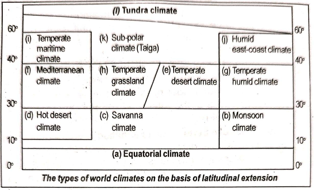
10. What are the types of climate?
Answer: The numerous types of climate include:
(i) Equatorial climate
(ii) Monsoon climate
(iii) Savanna or Sudan-type climate
(iv) Hot desert climate
(v) Temperate desert climate
(vi) Mediterranean climate
(vii) Temperate humid or Chinese climate
(viii) Temperate grassland climate
(ix) Temperate maritime climate
(x) Humid east-coast climate
(xi) Sub-polar (Taiga) climate
(xii) Tundra climate
(xiii) Mountain or Highland climate
11. State the various types of climate with suitable diagram.
Answer: The various types of climate on the basis of latitudinal extension is shown below:
12. Write short notes on the following:
(a) Relative humidity
(b) Atmospheric pressure
(c) Pressure belts
(d) Types of rainfall
(e) Effect of latitudes on climate
(f) Effect of vegetation on climate
(g) Monsoon climate
(h) Taiga type of climate
(i) Mediterranean climate
(j) Savanna climate
(k) Tundra climate
(L) Mountain climate
Answer:
(a) Relative humidity: Relative humidity is the ratio of the weight of water vapour present in a definite volume of air at definite temperature and the weight of water vapour necessary for saturation of the same volume of air at the same temperature. Generally, it is expressed in percentage.
 With the change of air temperature, the capacity to retain moisture increases and this also affects relative humidity. It is greater on the ocean and least over the continents. It is also very little over the desert areas.
(b) Atmospheric pressure: Atmospheric pressure means the force exerted by air on per unit area. The average atmospheric pressure at sea level at 15°C is 1013.2 mb (milibar). It is measured with the help of an instrument named barometer. Pressure differences are caused by variations in temperature and elevation. High temperature brings about low pressure and vice versa. Pressure decreases at the rate of 34 mb per 900 feet of height of atmosphere.
(c) Pressure belts: Due to variation in temperature, different places have different atmospheric pressure. On the basis of pressure variations on the surface of the earth, the following permanent pressure belts have been identified in the northern and southern hemisphere:
(i) Equatorial low pressure belt
(ii) Sub-tropical high pressure belt
(iii) Sub-polar low pressure belt
(iv) Polar high pressure belt
(d) Types of rainfall: Rainfall is one of the main forms of precipitation. It has a great influence on climate. Rainfall is of five types:
(i) Convectional rainfall: The air over the earth’s surface gets heated due to intense solar radiation and this heated air moves upward in the atmosphere. The water vapour contained in such air gets condensed and falls down as rain called convectional rainfall.
(ii) Oragraphic rainfall: Sometimes rain occurs due to the blocking of the moisture-laden winds by the hills and mountains forcing them to go up, get condensed and fall down as rain known as oragraphic rainfall or relief rain.
(iii) Cyclonic rainfall: The rainfall which occurs along with the cyclonic wind is known as cyclonic rainfall.
(iv) Latitudinal rainfall: The rainfall which occurs in some regions due to their latitudinal position is known as latitudinal rainfall. Generally such rains are caused by planetary or permanent winds blowing over certain latitudes.
(v) Forest rainfall: The air around forest has more moisture due to the respiration of the plants. When such air goes up, it gets condensed and falls down as rain, called forest rain.
(e) Effect of latitudes on climate: Latitude is the single most important factor determining the climate of a place. It controls the angle of incidence of the sun’s rays and the duration of daylight. Regions near the equator (low latitudes) receive direct, vertical sun rays throughout the year, resulting in high temperatures and a Tropical Climate. As latitude increases towards the poles (high latitudes), the sun’s rays become more oblique and spread over a larger area, leading to less intense heating, lower temperatures, and the formation of Temperate and Polar Climates.
(f) Effect of vegetation on climate: Vegetation, particularly dense forests, exerts a significant influence on the local and regional climate. Plants release moisture into the air through evapotranspiration, which increases humidity and promotes higher rainfall totals. Forest cover also moderates ground temperatures by reducing the amount of insolation that reaches the soil and by providing shade. Areas with dense vegetation tend to have cooler days and milder nights compared to barren regions, resulting in a more moderate climate. Extensive deforestation can thus lead to decreased rainfall and greater temperature extremes.
(g) Monsoon climate: The monsoon climate is experienced in the eastern parts of the countries in the northern hemisphere lying between 10°N and 40° N latitudes. This region experiences summer temperature between 27° C and 32°C. The average annual rainfall is between 100 and 200cm. The regions that receive annual rainfall between 100 and 200cm have deciduous type of forests while regions that get more than 200cm of rainfall have evergreen forests. The main areas that have this type of climate are India, Bangladesh, South-east Asia, Southern China, Southern Japan, North-east Africa, Mexico, Florida, Northern parts of Australia and Malagasy.
(h) Taiga type of climate: The sub-polar (Taiga) climate is experienced in the sub-polar region lying between 50° and 65° N and S lines of latitude. The average summer temperature ranges from 10°C to 30°C while average winter temperature goes down to 2.5°C. This climatic region experiences heavy snowfall and very little rainfall. The main vegetation found in this region is the coniferous forests. These coniferous forests are called Taiga in Siberia.
(i) Mediterranean climate: The latitudinal location of mediterranean climatic region is 30° and 45° north and south of the equator. The summer temperature of this With the change of air temperature, the capacity to retain moisture increases and this also affects relative humidity. It is greater on the ocean and least over the continents. It is also very little over the desert areas.
(j) Savanna climate: The savanna type of climate is also known as sudan type climate. This climate prevails in regions such as Sudan, Central India, North-central Africa, Southern Brazil, Argentina, Venezuela and Central parts of Central Australia. The average summer temperature is 27°C- 28°C and average winter temperature varies from 10°C to 15°C. The rainfall varies from 25cm to 40cm which encourages the growth of extensive grasslands. Such grasslands of Africa are called ‘Savanna’ while those of Brazil are called ‘Campos’.
(k) Tundra climate: The regions lying within the Arctic and Antarctic circles experience Tundra climate which prevails in the northern-most parts of Asia, Canada and Antarctica. The region under this climate receives sunshine of low intensity for almost six months and remaining six months are night. Summer temperature hardly goes up to 10°C while winter temperature drops down below 0°C. As the surface remains covered with ice for nine months of the year, so only lichens and some mosses grow. The population is sparse with some Eskimos and only a few other hunter groups live in such extreme cold climate.
(l) Mountain climate: Due to high elevation, mountains have different climatic conditions depending on the height. Equatorial type of climate prevails along the foothills region and with the increase in height climate changes. Alpine climate exists in the middle portion. Here the air remains cold and moderate rainfall takes place. Vegetation such as grasses, shrubs, coniferous trees are found here. The Alpine climate is suitable for sheep and cattle rearing. At high altitude, ‘tundra’ type of climate prevails. This type of climate is found in the high ranges of the mountains such as the Himalayas, Alps, Rockies, Andes, etc.
13. Answer the following questions:
(a) How far does the atmosphere extend above from the earth’s surface?
Answer:The Earth’s atmosphere extends vertically to an approximate distance of 10,000 kilometres outwards from the terrestrial surface.
(b) What is lapse rate?
Answer: Lapse rate denotes the rate at which the temperature decreases within the Troposphere corresponding to an increase in elevation or altitude. This standard lapse rate is established at 6.5^{\circ}\text{C} per kilometre of vertical ascent from the Earth’s surface through the atmosphere.
(c) What is the average atmospheric pressure on the sea level?
Answer: The typical atmospheric pressure at sea level, measured at a temperature of 15C°}, is recorded as 1013.2(mb)
(d) What is humidity of air?
Answer: The humidity of air is defined as the total quantity of water vapour that is contained within a specific volume of the air mass.
(e) What you mean by the term ‘saturated air’?
Answer: The term ‘saturated air’ refers to a specific volume of air that, at a given temperature, contains the maximum possible amount of water vapour it is capable of holding under those precise temperature conditions.
(f) What is the latitudinal extension of the equatorial climate?
Answer: The equatorial climate typically dominates the region situated between the equator and the 10^{\circ} \text{ North and South} lines of latitude.
(g) In which climate is the ‘campos’ grassland found?
Answer: The grassland known as ‘campos’ is found in the Savanna climate zone, which specifically occurs in the grasslands of Brazil.
(h) Mention the latitudinal extension of the temperate desert climate region.
Answer: The geographical extension of the temperate desert climate region spans between 30C° and 40C° North and South of the equator.
(i) What is the other name of the Chinese climate?
Answer:
The Chinese climate is alternatively referred to as the temperate humid climate.
(j) Give an example of the irregular wind.
Answer:
A Cyclone serves as a representative example of an irregular wind type.
(k) Why does the warm airmass have the capacity to hold more water vapour?
Answer: Increased temperature causes air to undergo expansion, thereby resulting in a decrease in air density. When the air’s density is reduced, it becomes lighter. This light air is better able to accommodate a greater quantity of water vapour. Such air then ascends and can more effectively collect atmospheric moisture. Thus, a warm air mass inherently possesses a greater capacity to hold water vapour.
(l) Why there is more atmospheric pressure at the lower level of the atmosphere?
Answer: Since air is a compressible substance, the air residing in the atmosphere’s lower layers becomes significantly compressed. This compression leads to a resultant increase in its density. When the density of the air increases, the pressure it exerts also rises. Consequently, the lower layer of the atmosphere registers a higher atmospheric pressure.
Class 9 Geography Chapter 1 – Frequently Asked Questions
Get Free NCERT PDFs
If you want to download free PDFs of any chapter, click the link below and join our WhatsApp group: