Class 9 Geography Chapter 4 – Human Settlement Complete Solutions | Assam Board (ASSEB) | Latest Syllabus | English Medium
Class 9 Geography Chapter 4 – Human Settlement Complete Solutions (Assam Board – ASSEB – English Medium)
This chapter explores the concept of human settlement, different types of settlements, their characteristics, and factors influencing their location and growth. Students will learn about rural and urban settlements and the patterns and functions of settlements across the world.
✅ What you will learn:
- Definition and importance of human settlements
- Types of settlements – rural and urban
- Factors influencing the location of settlements
- Settlement patterns and structures
- Functions and growth of settlements
🎯 Why choose Ospin Academy?
- Complete, easy-to-understand solutions for the latest Assam Board (ASSEB) syllabus
- English medium explanations suited for Class 9 students
- Focused practice questions to aid exam preparation
- Up-to-date, syllabus-aligned learning material
- Reliable and accessible digital resource for students

Class 9 Geography Elective English Medium | Latest Syllabus Chapter-wise Solutions PDF
Limited Time Offer!
(For Class 9 Geography Elective, English Medium)
Prepare thoroughly for Class 9 Geography Elective with this chapter-wise solutions PDF.
Includes complete, clear, and exam-focused textual solutions as per the latest syllabus.
Ideal for self-study, homework help, and last-minute revision.
Chapter-4
Human Settlement
1. What do you mean by ‘human settlement’? Discuss briefly about its origin and growth.
Answer: Human settlement refers to a place, either temporary or permanent, where people live and carry out their livelihood activities. The study of human settlement helps us understand the various factors that have influenced the growth and distribution of population in different regions of the world.
It is believed that human settlements began with the introduction of settled agriculture and the domestication of animals and plants around twelve thousand years ago. Before this period, humans led a nomadic life without permanent shelter. With the advancement of knowledge and skills, people started to establish permanent settlements in areas with favourable natural conditions.
The origin and expansion of human settlements were largely influenced by the availability of water, fertile soil, forests, and mineral resources. Water played a particularly vital role, as almost all early settlements developed near abundant water sources. This explains why ancient civilizations such as the Mesopotamian (on the banks of the Euphrates and Tigris), the Egyptian (on the Nile), the Chinese (on the Hwang Ho), and the Indus Valley (on the Indus) flourished along riverbanks.
Settlements also emerged in regions endowed with natural resources like forests and minerals. Irrigation systems, canals, and drains were developed to ensure a steady supply of water. Availability of fertile agricultural land further contributed to the growth of settlements — for example, cultivators in Europe chose fertile farmlands, while Mongoloid people migrating to Southeast Asia preferred river valleys and coastal plains suitable for rice cultivation.
Thus, factors such as water availability, fertile land, flood-free terrain, safety, housing materials, favourable climate, opportunities for trade, and religious or socio-cultural influences all contributed to the development and expansion of human settlements. Regions with rich mineral, forest, and power resources, or with advanced transport and communication facilities, witnessed faster settlement growth.
2. What is meant by ‘settlement geography’? Write briefly about its main subject matter.
Answer: Settlement geography is a branch of geography that studies human settlements, their development, and the physical, cultural, and socio-economic factors related to them. It is a relatively new field that deals with various aspects of settlement patterns and organization. The study methods of settlement geography were developed by the geographer Richard Hartshorne.
The main subject matter of settlement geography includes:
(i) Element-based study: This covers the study of settlement location, size, shape, and functional characteristics.
(ii) Region-based study: It focuses on the origin and development of settlements, changes in their form, spatial distribution, and regional variations in settlement characteristics.
Hence, the scope of settlement geography extends from the study of a simple hut to a modern skyscraper.
3. Present the classification of human settlements with examples.
Answer: Human settlements can be classified as follows:
[I] On the basis of occupation of people:
(a) Rural settlement: Found mainly in villages (e.g., agricultural villages).
(b) Urban settlement: Found in towns, cities, and megalopolises (e.g., Mumbai, Delhi).
[II] On the basis of form or shape:
(a) Dispersed settlement: Found in the agricultural belts of the USA.
(b) Nucleated settlement: Found in cities such as Mumbai and Kolkata.
[III] On the basis of division of nucleated settlement:
(a) Rectangular settlement: Found in the Ganga–Sutlej plains.
(b) Linear settlement: Found along the Ganga–Yamuna plains.
(c) Circular settlement: Found around lakes and ponds.
(d) Star-like settlement: Found near major road intersections.
(e) Triangular settlement: Found at the confluence of major rivers.
4. What do you mean by rural and urban settlements? Write the characteristic differences between these settlements.
Answer: Rural settlements refer to areas, generally villages, where the majority of people are engaged in agricultural and related occupations. Urban settlements, on the other hand, refer to towns and cities where people are mainly involved in trade, commerce, administration, industries, and other services.
The main characteristic differences between rural and urban settlements are:
|
Sl. No. |
Basis of difference |
Rural settlement |
Urban settlement |
|---|---|---|---|
|
(i) |
Occupation |
Agriculture, fishing, lumbering, cottage industries, etc. |
Manufacturing, trade, commerce and various services. |
|
(ii) |
Houses |
Huts or simple structures. |
Big and often multi-storeyed. |
|
(iii) |
Settlements |
Dispersed settlements. |
Nucleated settlements. |
|
(iv) |
Relationship |
Close relationship among the inhabitants. |
No close relationship among the inhabitants. |
|
(v) |
Landscape |
Natural and eco-friendly. |
Man-made and artificial. |
5. settlement and nucleated settlement. Mention the basic differences between dispersed
Answer: The differences between dispersed settlement and nucleated settlement are:
|
Sl. No. |
Basis of difference |
Dispersed settlement |
Nucleated settlement |
|---|---|---|---|
|
(i) |
Meaning |
Settlements that are spread far and wide in an area. |
Settlements established close to each other. |
|
(ii) |
Found in |
Found in agricultural areas. |
Found in urban areas. |
|
(iii) |
Consists |
Consists of one type. |
Consists of several types. |
|
(iv) |
Population |
Population size is small. |
Population size is big. |
6. Write in brief about the different types of settlements under the category of nucleated settlements with examples and diagrams.
Answer: On the basis of shape or pattern, nucleated settlements can be divided into the following types:
(i) Rectangular settlement: Settlement that comes up within a rectangular area created by straight roads and intersect at right angles is known as rectangular settlement. Such settlements mainly develop in the extensive fertile plain areas. e.g. Ganga-Sutlej plain region. Generally, whenever a city is planned a pattern of settlement is followed. Indian planned cities such as Chandigarh, Gandhinagar, etc. have mostly this type of settlements. Most of the planned cities of the developed countries such as Germany, Malaysia, Israel, France, etc. have planned settlement.
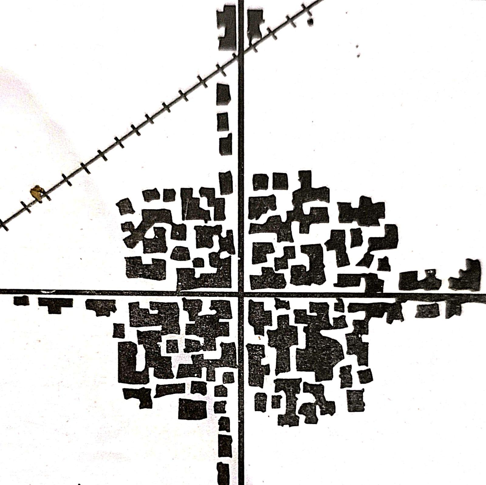
Fig. Rectangular or Square Settlement
(ii) Linear settlement: Settlements that grow along both
sides of the roads and railway lines, along the banks of rivers and irrigation canals, along the narrow river valleys of the mountain region or the coastal areas are called linear settlement. This type of settlement is found by the sides of the roads in the river valleys of India’s middle and lower Himalayas and the Ganga -Yamuna plain’s.
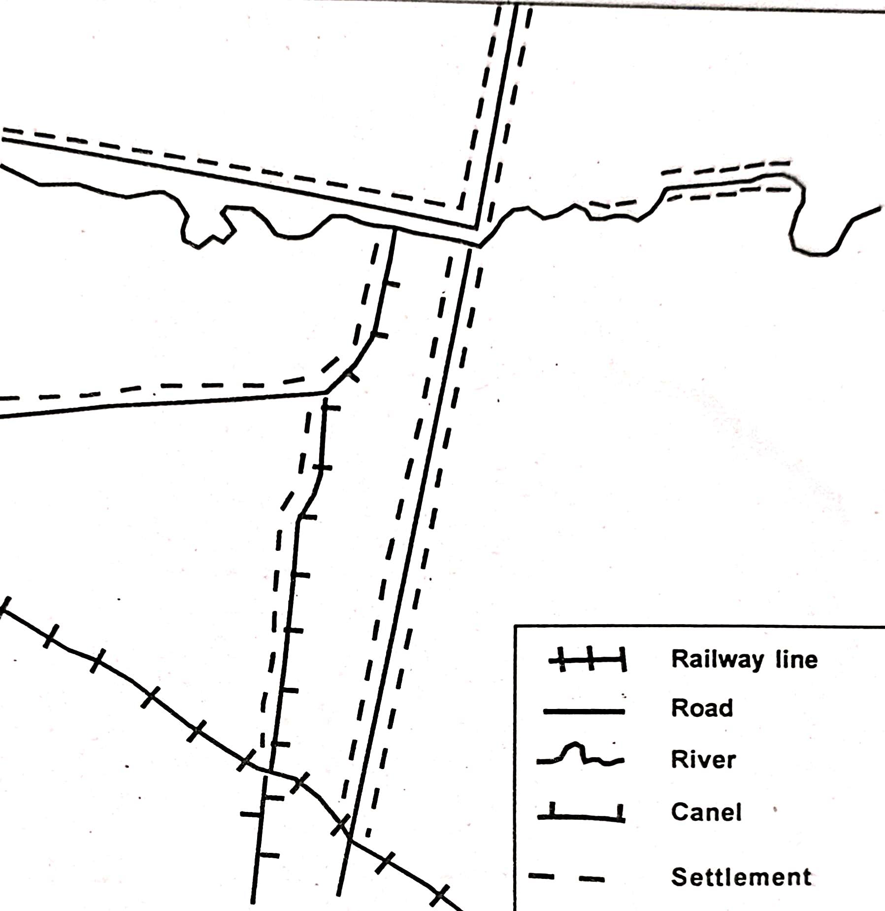
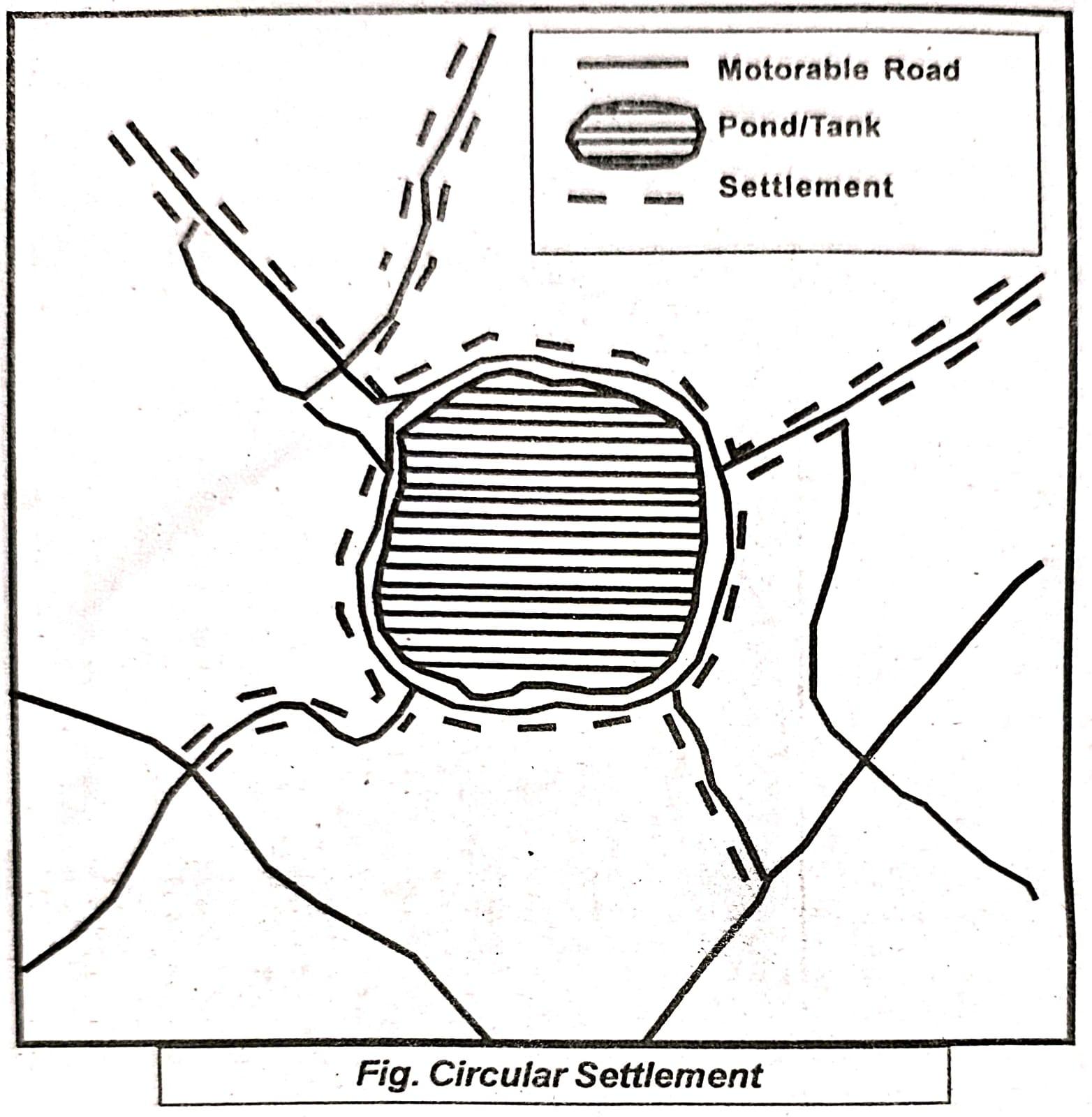
(iii) Circular settlement: Settlements developed by constructing houses around lakes, ponds, big tanks, etc. is called circular settlement.e.g. Fishing community often establishes their settlement close to lake or coast. Salt workers establish their settlement around salt lakes for the extraction of salt. Such settlements are also found around large industrial areas in the form of circular shape.
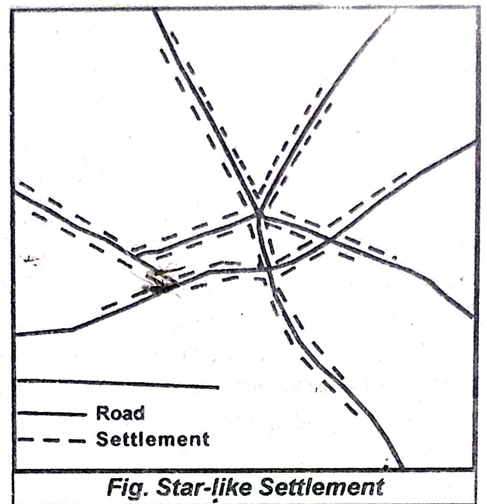
(iv) Star-like settlement: Settlements developed from a common centre in several directions like emerging of rays from the stars, along both sides of the roads, is called star-like settlement. This type of settlement is found at the intersection of roads in the plain areas. The basic feature of this type of settlement is that such settlements begin from an important cross junction and extend along the roads in many directions.

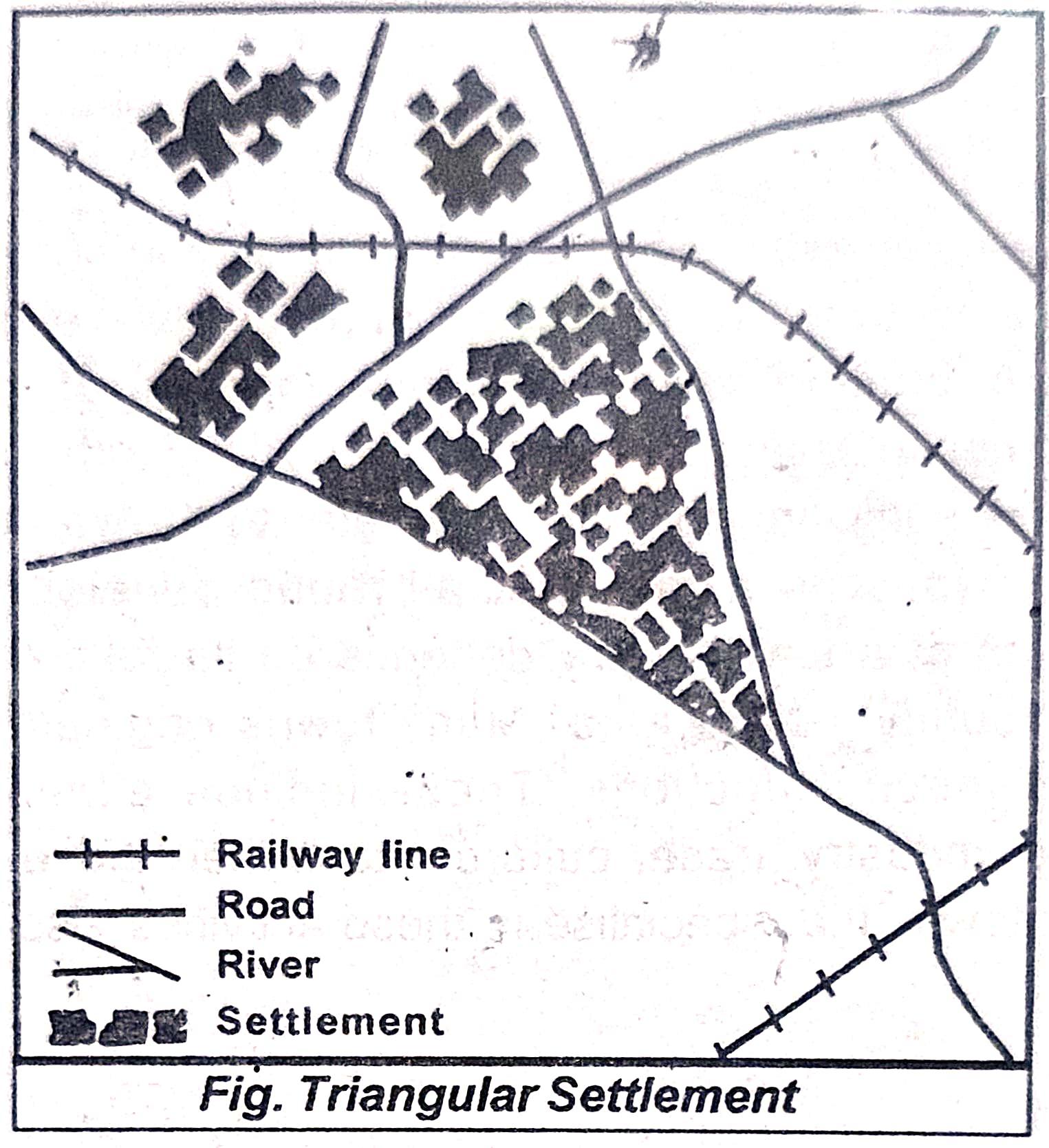
(v) Triangular settlement: Settlement of triangular shape developed at an intersection of two large rivers based on availability of water and fertile soil, is called triangular settlement. This type of settlement can be found in the riverine plains of North India and the confluences of many rivers in the foothill areas.

7. Write briefly about the origin and growth of urban settlements.
Answer: Most human settlements initially begin as small villages. Over time, these villages gradually develop into towns due to the presence of favourable physical and socio-economic conditions such as fertile soil, level land, adequate water supply, availability of building materials, good transport facilities, safety, and suitable religious, social, or economic factors. In some cases, political developments also play a significant role in transforming small villages into towns, which may later grow into large cities or even megalopolises.
As human civilisation advanced, urban growth influenced not only existing cities but also nearby villages. The economic activities of such villages often changed with time. For example, an agriculturally based settlement might evolve into a centre of trade and commerce. Similarly, the discovery of valuable minerals in or near a village could lead to its transformation into an industrial town. The rapid development of roads and transport networks can also convert a village into a small township. A coastal fishing village may, over time, develop into a fish trading centre.
However, an increase in population alone does not transform a village into a town. It is the growth of trade, commerce, industries, and various service activities that mark the transition from a rural settlement to an urban one.
The development and expansion of towns depend on several factors—favourable location, adequate water supply, efficient transport and communication systems, flourishing trade and commerce, industrial growth, and financial institutions. Additionally, a sufficient population is necessary to sustain the economic and social activities of the town.
The overall development and prosperity of a town are closely linked with its surrounding rural areas. Many towns emerge to serve specific purposes such as administration, defence, industry, trade, or culture. When these functions expand, the towns that specialise in them also experience rapid growth and further urban development.
8. Classify the urban settlements with examples according to functions.
Answer: The different types of settlement in accordance with functions are:
|
Sl. No. |
Urban Settlement |
Examples |
|---|---|---|
|
(i) |
Multiple functions |
Kolkata, Mumbai, Guwahati, etc. |
|
(ii) |
Administrative functions |
Gandhinagar, Chandigarh, etc. |
|
(iii) |
Defence functions |
Kanpur, Pune, Chennai, Bangalore, etc. |
|
(iv) |
Hill stations cum tourist centres |
Mussoorie, Darjeeling, Shillong, etc. |
|
(v) |
Pilgrim centres |
Varanasi, Puri, Rishikesh, etc. |
|
(vi) |
Sea port city |
Haldia, Paradeep, etc. |
|
(vii) |
Industrial towns |
Jamshedpur, Bhilai, Bokaro, etc. |
|
(viii) |
Educational towns |
Oxford, Cambridge, Pune, etc. |
9. What do you mean by ‘hierarchy of settlements’? Write about this with examples and diagrams.
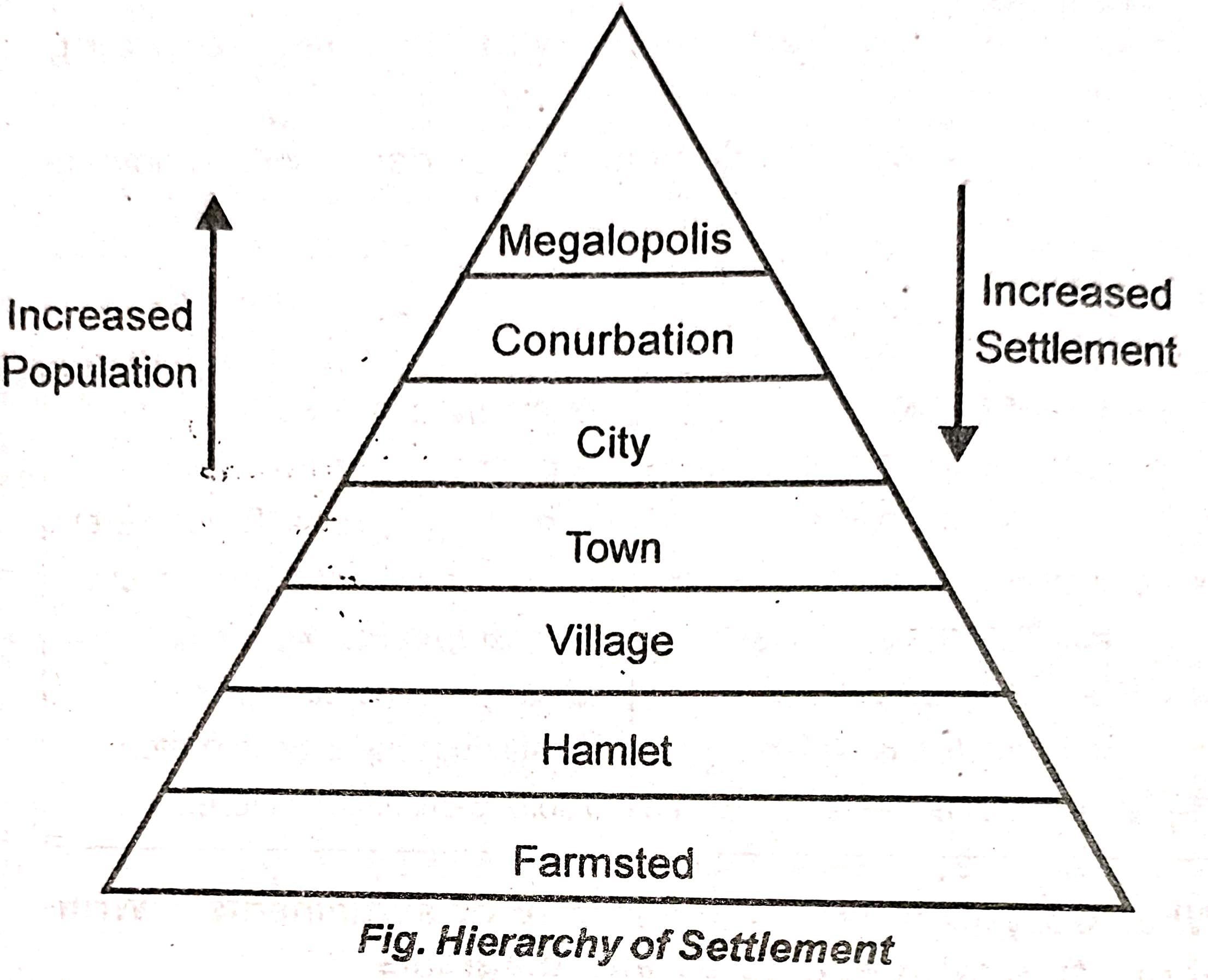
Answer: The term hierarchy of settlements refers to the systematic arrangement of all rural and urban settlements in an order based on their size, population, and functions—from the smallest to the largest. At the lowest level of this hierarchy are a few scattered houses or farmsteads, while at the top lies the megalopolis, representing the largest and most developed form of settlement.
In rural areas, the settlement hierarchy begins with isolated houses at the bottom and progresses through hamlets and villages at the top. In the urban context, the sequence starts with small towns and continues through cities and conurbations, ultimately reaching the megalopolis at the highest level.
As one moves upward in the settlement hierarchy, there are noticeable changes in size, population, area, functions, and available facilities. The higher the level, the larger the population and the wider the range of services offered. At the same time, the number of settlements decreases with each higher level. For instance, there are far fewer cities than towns, and fewer towns than villages.
To illustrate, the population of small towns in India is around 5,000, whereas Mumbai had about 16 million people according to the 2001 Census. In Assam, Guwahati is the largest city with over 9 lakh residents, while out of 125 towns in the state, only 7 have populations exceeding one lakh.
Thus, the settlement hierarchy reflects not only the population and size differences among settlements but also their functional importance and level of urban development.

10. Write briefly about the landuse pattern of rural and urban settlements.
Answer: There exists a clear distinction between the landuse pattern of rural and urban areas. Rural settlements are mainly associated with primary occupations such as agriculture, livestock rearing, forestry, woodcutting, and the extraction of natural resources. In contrast, urban settlements show a greater degree of vertical land use, as the expansion of buildings and infrastructure is more rapid than in rural areas.
Population density, land value, literacy rate, transport facilities, and the variety of socio-economic activities generally decrease with increasing distance from an urban centre. The rural landscape remains largely natural and dependent on the environment, while the urban landscape is largely man-made and built up.
According to geographer C. A. Doxiadis, a human settlement can be divided into four parts:
(i) Homogeneous part
(ii) Central part
(iii) Circulatory part
(iv) Special part
(a) In the rural context:
The homogeneous part represents agricultural land.
The central part comprises houses and dwellings.
The circulatory part includes road networks.
The special part consists of social, cultural, and economic institutions such as temples and schools.
(b) In the urban context:
The homogeneous part includes residential areas.
The central part consists of commercial and financial establishments.
The circulatory part includes roads and transport systems.
The special part comprises specialised institutions and services.
The landuse pattern of urban areas generally follows a distinct structure across most countries:
(i) The central area of towns and cities is dominated by trade and commerce.
(ii) Various commercial establishments, banks, offices, and retail and wholesale centres are concentrated here.
(iii) This area is usually characterised by high-rise buildings and costly market zones, known as the Central Business District (CBD).
(iv) With increasing distance from the core, changes in land use occur. The surrounding circular zone accommodates residential complexes, industries, educational institutions, and suburban developments.
(v) Further beyond the urban fringe, agricultural activities again become prominent.
11. What do you mean by ‘Central Business District’? Mention its basic characteristics.
Answer: The Central Business District (CBD) refers to the central portion of a city or town where trade, commerce, and financial institutions are highly concentrated. It serves as the commercial and economic core of the urban area.
The major characteristics of a CBD are:
(i) The land is primarily used for commercial and business purposes.
(ii) The value of land is very high.
(iii) It functions as the main hub of trade, business, and financial transactions of the city.
(iv) There are very few residential buildings within the CBD.
(v) As one moves outward from the CBD, institutions such as schools, temples, churches, and industries are commonly found in the surrounding areas.
(vi) The area is well-connected with an excellent network of transport and communication systems.
12. Write briefly about the relationship between rural and urban settlements.
Answer: There exists a strong interdependence between rural and urban settlements. Both types of settlements rely on each other for various goods and services. Rural villages depend on nearby towns for education, healthcare, banking, entertainment, and the purchase of consumer and luxury goods. Agricultural products from villages find suitable markets in urban areas, while many rural youths—both skilled and unskilled—seek employment opportunities in towns and cities.
Conversely, urban centres depend heavily on rural areas for food supplies, raw materials, and labour. Many urban institutions such as hospitals, markets, banks, and theatres sustain their operations with the support of surrounding rural populations.
Thus, the rural and urban sectors of a nation are closely connected and mutually supportive. Modern means of transport and communication have further strengthened this vital relationship between the two areas.
13. Write short notes:
(a) Human settlements and settlement geography
(b) Linear settlement
(c) Circular settlement
(d) Star-like settlement
(e) Culture and educational town
(f) Rural-urban continuum
(g) Hierarchy of settlements
(h) Urban fringe
(i) Satellite town
Ans.
(a) Human settlements and settlement geography:
Human settlement refers to a temporary or permanent cluster of dwellings where people live and carry out various activities for their livelihood. It includes villages, towns, and cities.
Settlement geography, on the other hand, is a branch of geography that studies human settlements — their location, growth, structure, functions, and the influence of physical, social, cultural, and economic factors on them. It helps us understand how and why people occupy particular areas of the earth’s surface.
(b) Linear settlement:
A linear settlement develops along a line, such as a river, road, railway line, or coastline. The houses and other structures are arranged in a straight or slightly curved line following the physical feature or transport route.
Example: Settlements along the Ganga–Yamuna plains and roadsides in hilly areas often display this pattern.
(c) Circular settlement:
A circular settlement develops around a central point such as a lake, pond, or temple. The houses are arranged in a circular form surrounding the central feature.
Example: Villages located around water bodies or religious centres commonly exhibit circular settlement patterns.
(d) Star-like settlement:
A star-like or radial settlement develops at the intersection of several roads or transport routes radiating outward from a central point. The houses and buildings extend along these routes, giving the appearance of a star.
Example: Settlements growing around major road junctions or crossroads often take this form.
(e) Culture and educational town:
A culture and educational town is one that develops primarily around cultural, academic, or religious institutions. Such towns attract people for higher studies, research, or cultural activities.
Examples: Varanasi and Shantiniketan in India are notable as cultural and educational centres.
(f) Rural-urban continuum:
The rural-urban continuum refers to the gradual blending or merging of rural and urban features. It indicates that there is no sharp division between villages and cities — instead, one slowly transforms into the other through semi-urban areas or small towns.
This concept highlights the continuous interaction and interdependence between rural and urban settlements.
(g) Hierarchy of settlements:
The hierarchy of settlements represents the arrangement of settlements in order of their size, population, and functions — from the smallest to the largest.
At the base are isolated houses and hamlets, followed by villages, towns, cities, and at the top, megalopolises. As we move upward in the hierarchy, the size, population, and number of functions increase, while the number of such settlements decreases.
(h) Urban fringe:
The urban fringe is the transitional zone lying between a city’s built-up area and the surrounding rural region. It often contains a mixture of urban and rural land uses such as housing colonies, small industries, vegetable farms, and markets.
It serves as the area of expansion where urban growth gradually spreads into the countryside.
(i) Satellite town:
A satellite town is a smaller town developed near a large city to reduce congestion and pressure on the main city. It functions independently but maintains close economic and social links with the parent city.
Examples: Gurgaon near Delhi and Navi Mumbai near Mumbai are well-known satellite towns in India.
14. Prepare a sketch-map of your village or town showing the human settlements including the location of school, namghar (prayer hall), shop, etc. under the guidance of your teacher and mention the type of settlement.
Answer: Self Task
Chapter-4
Human Settlement
1. What do you mean by ‘human settlement’? Discuss briefly about its origin and growth.
Answer: Human settlement refers to a place, either temporary or permanent, where people live and carry out their livelihood activities. The study of human settlement helps us understand the various factors that have influenced the growth and distribution of population in different regions of the world.
It is believed that human settlements began with the introduction of settled agriculture and the domestication of animals and plants around twelve thousand years ago. Before this period, humans led a nomadic life without permanent shelter. With the advancement of knowledge and skills, people started to establish permanent settlements in areas with favourable natural conditions.
The origin and expansion of human settlements were largely influenced by the availability of water, fertile soil, forests, and mineral resources. Water played a particularly vital role, as almost all early settlements developed near abundant water sources. This explains why ancient civilizations such as the Mesopotamian (on the banks of the Euphrates and Tigris), the Egyptian (on the Nile), the Chinese (on the Hwang Ho), and the Indus Valley (on the Indus) flourished along riverbanks.
Settlements also emerged in regions endowed with natural resources like forests and minerals. Irrigation systems, canals, and drains were developed to ensure a steady supply of water. Availability of fertile agricultural land further contributed to the growth of settlements — for example, cultivators in Europe chose fertile farmlands, while Mongoloid people migrating to Southeast Asia preferred river valleys and coastal plains suitable for rice cultivation.
Thus, factors such as water availability, fertile land, flood-free terrain, safety, housing materials, favourable climate, opportunities for trade, and religious or socio-cultural influences all contributed to the development and expansion of human settlements. Regions with rich mineral, forest, and power resources, or with advanced transport and communication facilities, witnessed faster settlement growth.
2. What is meant by ‘settlement geography’? Write briefly about its main subject matter.
Answer: Settlement geography is a branch of geography that studies human settlements, their development, and the physical, cultural, and socio-economic factors related to them. It is a relatively new field that deals with various aspects of settlement patterns and organization. The study methods of settlement geography were developed by the geographer Richard Hartshorne.
The main subject matter of settlement geography includes:
(i) Element-based study: This covers the study of settlement location, size, shape, and functional characteristics.
(ii) Region-based study: It focuses on the origin and development of settlements, changes in their form, spatial distribution, and regional variations in settlement characteristics.
Hence, the scope of settlement geography extends from the study of a simple hut to a modern skyscraper.
3. Present the classification of human settlements with examples.
Answer: Human settlements can be classified as follows:
[I] On the basis of occupation of people:
(a) Rural settlement: Found mainly in villages (e.g., agricultural villages).
(b) Urban settlement: Found in towns, cities, and megalopolises (e.g., Mumbai, Delhi).
[II] On the basis of form or shape:
(a) Dispersed settlement: Found in the agricultural belts of the USA.
(b) Nucleated settlement: Found in cities such as Mumbai and Kolkata.
[III] On the basis of division of nucleated settlement:
(a) Rectangular settlement: Found in the Ganga–Sutlej plains.
(b) Linear settlement: Found along the Ganga–Yamuna plains.
(c) Circular settlement: Found around lakes and ponds.
(d) Star-like settlement: Found near major road intersections.
(e) Triangular settlement: Found at the confluence of major rivers.
4. What do you mean by rural and urban settlements? Write the characteristic differences between these settlements.
Answer: Rural settlements refer to areas, generally villages, where the majority of people are engaged in agricultural and related occupations. Urban settlements, on the other hand, refer to towns and cities where people are mainly involved in trade, commerce, administration, industries, and other services.
The main characteristic differences between rural and urban settlements are:
|
Sl. No. |
Basis of difference |
Rural settlement |
Urban settlement |
|---|---|---|---|
|
(i) |
Occupation |
Agriculture, fishing, lumbering, cottage industries, etc. |
Manufacturing, trade, commerce and various services. |
|
(ii) |
Houses |
Huts or simple structures. |
Big and often multi-storeyed. |
|
(iii) |
Settlements |
Dispersed settlements. |
Nucleated settlements. |
|
(iv) |
Relationship |
Close relationship among the inhabitants. |
No close relationship among the inhabitants. |
|
(v) |
Landscape |
Natural and eco-friendly. |
Man-made and artificial. |
5. settlement and nucleated settlement. Mention the basic differences between dispersed
Answer: The differences between dispersed settlement and nucleated settlement are:
|
Sl. No. |
Basis of difference |
Dispersed settlement |
Nucleated settlement |
|---|---|---|---|
|
(i) |
Meaning |
Settlements that are spread far and wide in an area. |
Settlements established close to each other. |
|
(ii) |
Found in |
Found in agricultural areas. |
Found in urban areas. |
|
(iii) |
Consists |
Consists of one type. |
Consists of several types. |
|
(iv) |
Population |
Population size is small. |
Population size is big. |
6. Write in brief about the different types of settlements under the category of nucleated settlements with examples and diagrams.
Answer: On the basis of shape or pattern, nucleated settlements can be divided into the following types:
(i) Rectangular settlement: Settlement that comes up within a rectangular area created by straight roads and intersect at right angles is known as rectangular settlement. Such settlements mainly develop in the extensive fertile plain areas. e.g. Ganga-Sutlej plain region. Generally, whenever a city is planned a pattern of settlement is followed. Indian planned cities such as Chandigarh, Gandhinagar, etc. have mostly this type of settlements. Most of the planned cities of the developed countries such as Germany, Malaysia, Israel, France, etc. have planned settlement.

Fig. Rectangular or Square Settlement
(ii) Linear settlement: Settlements that grow along both
sides of the roads and railway lines, along the banks of rivers and irrigation canals, along the narrow river valleys of the mountain region or the coastal areas are called linear settlement. This type of settlement is found by the sides of the roads in the river valleys of India’s middle and lower Himalayas and the Ganga -Yamuna plain’s.

(iii) Circular settlement: Settlements developed by constructing houses around lakes, ponds, big tanks, etc. is called circular settlement.e.g. Fishing community often establishes their settlement close to lake or coast. Salt workers establish their settlement around salt lakes for the extraction of salt. Such settlements are also found around large industrial areas in the form of circular shape.

(iv) Star-like settlement: Settlements developed from a common centre in several directions like emerging of rays from the stars, along both sides of the roads, is called star-like settlement. This type of settlement is found at the intersection of roads in the plain areas. The basic feature of this type of settlement is that such settlements begin from an important cross junction and extend along the roads in many directions.
(v) Triangular settlement: Settlement of triangular shape developed at an intersection of two large rivers based on availability of water and fertile soil, is called triangular settlement. This type of settlement can be found in the riverine plains of North India and the confluences of many rivers in the foothill areas.
7. Write briefly about the origin and growth of urban settlements.
Answer: Most human settlements initially begin as small villages. Over time, these villages gradually develop into towns due to the presence of favourable physical and socio-economic conditions such as fertile soil, level land, adequate water supply, availability of building materials, good transport facilities, safety, and suitable religious, social, or economic factors. In some cases, political developments also play a significant role in transforming small villages into towns, which may later grow into large cities or even megalopolises.
As human civilisation advanced, urban growth influenced not only existing cities but also nearby villages. The economic activities of such villages often changed with time. For example, an agriculturally based settlement might evolve into a centre of trade and commerce. Similarly, the discovery of valuable minerals in or near a village could lead to its transformation into an industrial town. The rapid development of roads and transport networks can also convert a village into a small township. A coastal fishing village may, over time, develop into a fish trading centre.
However, an increase in population alone does not transform a village into a town. It is the growth of trade, commerce, industries, and various service activities that mark the transition from a rural settlement to an urban one.
The development and expansion of towns depend on several factors—favourable location, adequate water supply, efficient transport and communication systems, flourishing trade and commerce, industrial growth, and financial institutions. Additionally, a sufficient population is necessary to sustain the economic and social activities of the town.
The overall development and prosperity of a town are closely linked with its surrounding rural areas. Many towns emerge to serve specific purposes such as administration, defence, industry, trade, or culture. When these functions expand, the towns that specialise in them also experience rapid growth and further urban development.
8. Classify the urban settlements with examples according to functions.
Answer: The different types of settlement in accordance with functions are:
|
Sl. No. |
Urban Settlement |
Examples |
|---|---|---|
|
(i) |
Multiple functions |
Kolkata, Mumbai, Guwahati, etc. |
|
(ii) |
Administrative functions |
Gandhinagar, Chandigarh, etc. |
|
(iii) |
Defence functions |
Kanpur, Pune, Chennai, Bangalore, etc. |
|
(iv) |
Hill stations cum tourist centres |
Mussoorie, Darjeeling, Shillong, etc. |
|
(v) |
Pilgrim centres |
Varanasi, Puri, Rishikesh, etc. |
|
(vi) |
Sea port city |
Haldia, Paradeep, etc. |
|
(vii) |
Industrial towns |
Jamshedpur, Bhilai, Bokaro, etc. |
|
(viii) |
Educational towns |
Oxford, Cambridge, Pune, etc. |
9. What do you mean by ‘hierarchy of settlements’? Write about this with examples and diagrams.
Answer: The term hierarchy of settlements refers to the systematic arrangement of all rural and urban settlements in an order based on their size, population, and functions—from the smallest to the largest. At the lowest level of this hierarchy are a few scattered houses or farmsteads, while at the top lies the megalopolis, representing the largest and most developed form of settlement.
In rural areas, the settlement hierarchy begins with isolated houses at the bottom and progresses through hamlets and villages at the top. In the urban context, the sequence starts with small towns and continues through cities and conurbations, ultimately reaching the megalopolis at the highest level.
As one moves upward in the settlement hierarchy, there are noticeable changes in size, population, area, functions, and available facilities. The higher the level, the larger the population and the wider the range of services offered. At the same time, the number of settlements decreases with each higher level. For instance, there are far fewer cities than towns, and fewer towns than villages.
To illustrate, the population of small towns in India is around 5,000, whereas Mumbai had about 16 million people according to the 2001 Census. In Assam, Guwahati is the largest city with over 9 lakh residents, while out of 125 towns in the state, only 7 have populations exceeding one lakh.
Thus, the settlement hierarchy reflects not only the population and size differences among settlements but also their functional importance and level of urban development.
10. Write briefly about the landuse pattern of rural and urban settlements.
Answer: There exists a clear distinction between the landuse pattern of rural and urban areas. Rural settlements are mainly associated with primary occupations such as agriculture, livestock rearing, forestry, woodcutting, and the extraction of natural resources. In contrast, urban settlements show a greater degree of vertical land use, as the expansion of buildings and infrastructure is more rapid than in rural areas.
Population density, land value, literacy rate, transport facilities, and the variety of socio-economic activities generally decrease with increasing distance from an urban centre. The rural landscape remains largely natural and dependent on the environment, while the urban landscape is largely man-made and built up.
According to geographer C. A. Doxiadis, a human settlement can be divided into four parts:
(i) Homogeneous part
(ii) Central part
(iii) Circulatory part
(iv) Special part
(a) In the rural context:
The homogeneous part represents agricultural land.
The central part comprises houses and dwellings.
The circulatory part includes road networks.
The special part consists of social, cultural, and economic institutions such as temples and schools.
(b) In the urban context:
The homogeneous part includes residential areas.
The central part consists of commercial and financial establishments.
The circulatory part includes roads and transport systems.
The special part comprises specialised institutions and services.
The landuse pattern of urban areas generally follows a distinct structure across most countries:
(i) The central area of towns and cities is dominated by trade and commerce.
(ii) Various commercial establishments, banks, offices, and retail and wholesale centres are concentrated here.
(iii) This area is usually characterised by high-rise buildings and costly market zones, known as the Central Business District (CBD).
(iv) With increasing distance from the core, changes in land use occur. The surrounding circular zone accommodates residential complexes, industries, educational institutions, and suburban developments.
(v) Further beyond the urban fringe, agricultural activities again become prominent.
11. What do you mean by ‘Central Business District’? Mention its basic characteristics.
Answer: The Central Business District (CBD) refers to the central portion of a city or town where trade, commerce, and financial institutions are highly concentrated. It serves as the commercial and economic core of the urban area.
The major characteristics of a CBD are:
(i) The land is primarily used for commercial and business purposes.
(ii) The value of land is very high.
(iii) It functions as the main hub of trade, business, and financial transactions of the city.
(iv) There are very few residential buildings within the CBD.
(v) As one moves outward from the CBD, institutions such as schools, temples, churches, and industries are commonly found in the surrounding areas.
(vi) The area is well-connected with an excellent network of transport and communication systems.
12. Write briefly about the relationship between rural and urban settlements.
Answer: There exists a strong interdependence between rural and urban settlements. Both types of settlements rely on each other for various goods and services. Rural villages depend on nearby towns for education, healthcare, banking, entertainment, and the purchase of consumer and luxury goods. Agricultural products from villages find suitable markets in urban areas, while many rural youths—both skilled and unskilled—seek employment opportunities in towns and cities.
Conversely, urban centres depend heavily on rural areas for food supplies, raw materials, and labour. Many urban institutions such as hospitals, markets, banks, and theatres sustain their operations with the support of surrounding rural populations.
Thus, the rural and urban sectors of a nation are closely connected and mutually supportive. Modern means of transport and communication have further strengthened this vital relationship between the two areas.
13. Write short notes:
(a) Human settlements and settlement geography
(b) Linear settlement
(c) Circular settlement
(d) Star-like settlement
(e) Culture and educational town
(f) Rural-urban continuum
(g) Hierarchy of settlements
(h) Urban fringe
(i) Satellite town
Ans.
(a) Human settlements and settlement geography:
Human settlement refers to a temporary or permanent cluster of dwellings where people live and carry out various activities for their livelihood. It includes villages, towns, and cities.
Settlement geography, on the other hand, is a branch of geography that studies human settlements — their location, growth, structure, functions, and the influence of physical, social, cultural, and economic factors on them. It helps us understand how and why people occupy particular areas of the earth’s surface.
(b) Linear settlement:
A linear settlement develops along a line, such as a river, road, railway line, or coastline. The houses and other structures are arranged in a straight or slightly curved line following the physical feature or transport route.
Example: Settlements along the Ganga–Yamuna plains and roadsides in hilly areas often display this pattern.
(c) Circular settlement:
A circular settlement develops around a central point such as a lake, pond, or temple. The houses are arranged in a circular form surrounding the central feature.
Example: Villages located around water bodies or religious centres commonly exhibit circular settlement patterns.
(d) Star-like settlement:
A star-like or radial settlement develops at the intersection of several roads or transport routes radiating outward from a central point. The houses and buildings extend along these routes, giving the appearance of a star.
Example: Settlements growing around major road junctions or crossroads often take this form.
(e) Culture and educational town:
A culture and educational town is one that develops primarily around cultural, academic, or religious institutions. Such towns attract people for higher studies, research, or cultural activities.
Examples: Varanasi and Shantiniketan in India are notable as cultural and educational centres.
(f) Rural-urban continuum:
The rural-urban continuum refers to the gradual blending or merging of rural and urban features. It indicates that there is no sharp division between villages and cities — instead, one slowly transforms into the other through semi-urban areas or small towns.
This concept highlights the continuous interaction and interdependence between rural and urban settlements.
(g) Hierarchy of settlements:
The hierarchy of settlements represents the arrangement of settlements in order of their size, population, and functions — from the smallest to the largest.
At the base are isolated houses and hamlets, followed by villages, towns, cities, and at the top, megalopolises. As we move upward in the hierarchy, the size, population, and number of functions increase, while the number of such settlements decreases.
(h) Urban fringe:
The urban fringe is the transitional zone lying between a city’s built-up area and the surrounding rural region. It often contains a mixture of urban and rural land uses such as housing colonies, small industries, vegetable farms, and markets.
It serves as the area of expansion where urban growth gradually spreads into the countryside.
(i) Satellite town:
A satellite town is a smaller town developed near a large city to reduce congestion and pressure on the main city. It functions independently but maintains close economic and social links with the parent city.
Examples: Gurgaon near Delhi and Navi Mumbai near Mumbai are well-known satellite towns in India.
14. Prepare a sketch-map of your village or town showing the human settlements including the location of school, namghar (prayer hall), shop, etc. under the guidance of your teacher and mention the type of settlement.
Answer: Self Task
Class 9 Geography Chapter 4 – Frequently Asked Questions
Get Free NCERT PDFs
If you want to download free PDFs of any chapter, click the link below and join our WhatsApp group: